Forecast for the Uintas Area Mountains

Mark Staples
Issued by Mark Staples for
Monday, March 11, 2024
Above treeline the danger is MODERATE where you could still trigger a slab of wind drifted snow but this problem is easy to avoid. Also watch for giant cornices.
Near and below treeline outside of where the wind has drifted snow, the avalanche danger is LOW.
Low
Moderate
Considerable
High
Extreme
Learn how to read the forecast here
Weather and Snow
After a beautiful sunny weekend, we're in for a few days of stormy weather. This morning temperatures are mostly in the low to mid 20s F. Increased winds from the south have been blowing for the last 36 hours 20-30 mph with gusts up to 40 mph.
Today, morning sunshine will give way to cloudy skies as a "weak and fast moving storm" moves over the Uintas bringing a dusting of snow. Temperatures will warm to near freezing again but will be dependent on how much sunshine vs how much clouds are in the sky. Winds from the south should remain elevated until late this afternoon.
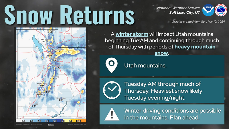
The National Weather Service is calling for 6-10 inches of snow for the Uintas mostly falling late Tuesday through Wednesday. Fingers crossed!
Most slopes receiving direct sunshine should have an ice crust on them this morning that may not soften. More shaded slopes still have soft, dense powder and go-anywhere conditions.
Recent Avalanches
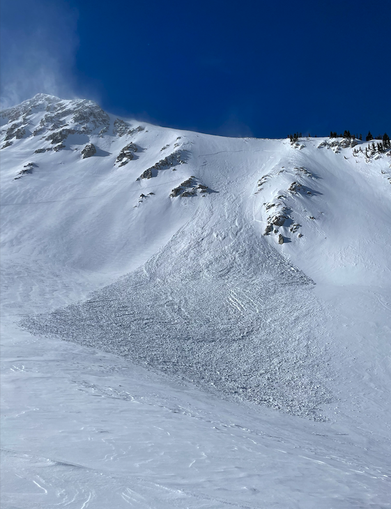
South winds during the last day and a half have been forming slabs of wind drifted snow at upper elevations. Skiers in the Wasatch triggered several yesterday (photo below) and similar ones could be triggered in the Uintas. On Saturday, Ted was also able to trigger shallow wind slabs on a small test slope near Bald Mountain.


Cornices continue to grow and can break unpredictably. Craig describes this giant cornice fall in his video below.

For all Uinta observations and recent avalanche activity click HERE.
Ad
Avalanche Problem #1
Wind Drifted Snow
Type
Location
Likelihood
Size
Description
Winds from the south have been blowing all night, and fresh wind slabs at upper elevations should be possible to trigger today. Look for rounded, pillowy drifts near ridgelines above treeline where these slabs exist and avoid them or stay in the trees and avoid this problem altogether.
Forecaster Dave Kelly rode near Double Hill and Moffit Peak and found this recent wind slab likely triggered by a rider. Not the most dangerous avalanche in this terrain but something to be prepared for.
Avalanche Problem #2
Persistent Weak Layer
Type
Location
Likelihood
Size
Description
There is a remote possibility of triggering a deep slide breaking at the ground in upper elevation terrain, but you'd have to get unlucky. Just avoid places where you think there's a good chance of hitting rocks which is where you'd have to be to trigger one of these slides.
I found deep, strong, and stable snow on Saturday in the near treeline elevations.
Additional Information
The Uinta weather station network was upgraded this summer and all that real-time info is found HERE. Simply click on "western Uinta" tab and then "weather stations" tab.

We are always looking for snow and avalanche observations or just general riding conditions. So... if you see something, say something. You can reach me directly at [email protected] or 801-231-2170.
Also, if you're looking for more avy education opportunities for yourself, your crew, or your club please don't hesitate to reach out to me and we'll find a presentation, class, or clinic for ya!
General Announcements

Issued at 0700 on Monday, March 11th this forecast will be updated by 0700 Tuesday, March 12th, 2024.
This forecast is from the U.S.D.A. Forest Service, which is solely responsible for its content. This forecast describes general avalanche conditions and local variations always occur.