Forecast for the Uintas Area Mountains

Craig Gordon
Issued by Craig Gordon for
Monday, February 27, 2023
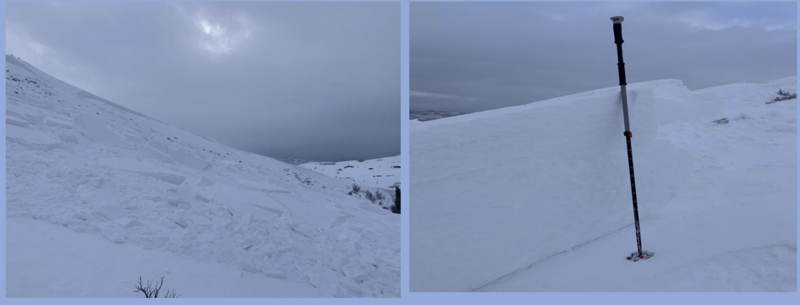
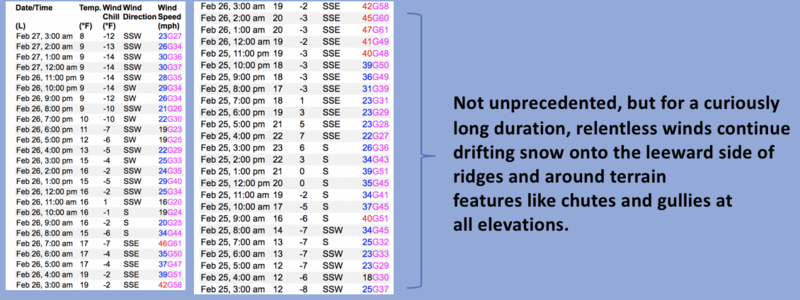
Fresh snow coupled with recent winds produce an elevated avy danger-
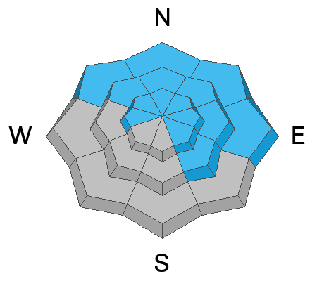
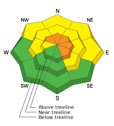
Human triggered avalanches are LIKELY on steep, leeward slopes in the wind zone at and above treeline, where you'll find CONSIDERABLE avalanche danger. With a little provocation, both new and older wind drifts react to our additional weight and today's slides will pack a punch, especially in terrain facing the north half of the compass. While not as obvious or widespread, MODERATE avalanche danger is found in mid and lower elevation terrain where human triggered avalanches are POSSIBLE on steep slopes with recent deposits of wind drifted snow.
If you're looking for an exit strategy... LOW avalanche danger exists on many slopes facing the south half of the compass.

Low
Moderate
Considerable
High
Extreme
Learn how to read the forecast here
Weather and Snow
Nowcast- Moisture began filling in over the region right around the turn of the new day delivering a nice shot of North Slope favored snowfall. Looks like 3" stacked up around the trailheads with nearly 6" piling up as you gain elevation. The south half of the range is slow to get in on the party with half that amount. Southerly winds are robust along the ridges, blowing 25-35 mph as temperatures register in the teens and single digits. There's been a lot of wind damage in the alpine and a little fresh snow will go a long way, though I'd steer towards mid elevation, wind sheltered terrain where you'll be rewarded with less wind funk and cold, creamy snow.
Forecast- Snow continues stacking up this morning with an additional 4"-6" expected. Temperatures climb into the mid 20's while south and southwest winds blow in the 30's near the peaks.
Futurecast- A slight break in the action midday is short-lived as another band of moisture is hot on its heels and a foot of snow seems like a good bet overnight.
Looks like a prolonged period of snow is on tap for us!
Detailed trip reports and recent obs are found HERE.
Recent Avalanches
As an ardent foothill skier, I should've seen this one coming... yup, our below treeline elevations are getting in on the act. While a foothill snowpack isn't completely unusual, human triggered avalanches in this elevation band are. This skier triggered slide in Browns Canyon yesterday is a bit unique, and speaks to the fact that we've got a big snow year with contiguous snow running tip to tail... from the valley floor to the ridgelines.
More slides from the weekend ... from Mt. Watson, to Hoyt Peak, to Double Hill, and Upper Chalk Creek, pockety fresh drifts forming on steep, leeward slopes were sensitive to the additional weight of a rider.
No other significant avalanche activity to report, but if ya wanna geek out, click HERE to track this years slide activity throughout the range.
Ad
Avalanche Problem #1
Wind Drifted Snow
Type
Location
Likelihood
Size
Description
Recent trends in wind speed, direction, and duration from Windy Peak (10,662').
Pretty straight-forward... southerly winds have blown for several days and there's no shortage of snow to blow around and form drifts on the leeward side of ridges and around terrain features like chutes and gullies. Found mostly in the wind zone above treeline, plenty of fresh drifts formed in lower elevations as well. I bet if you were looking for a wind slab to trigger... you can find one and it might break a little deeper than you'd expect. Here's where it gets tricky... drifts will be camouflaged by new snow, making them harder to detect. Today, you'll want to look for and avoid fat, rounded pieces of snow, especially if they sound of feel hollow like a drum. You know avoidance is the ticket, so be ready to pump the brakes on objectives if you're seeing shooting cracks out in front your your skis, board, or sled. This is an easy avalanche dragon to avoid... lose the wind and you lose the problem.

Additional Information
Weather stations-
And... rime events have severely crippled the Uinta weather station network. I'm working to get it back up and running, but a few stations are found HERE (click weather stations, and then on the Western Uinta tab)
Observations-
Your observations are important, so please let me know what you're seeing... click HERE and contribute to this amazing community-based program
General Announcements
Issued at 03:39 on Monday February 27th, this forecast expires 24 hours after the date and time posted, but will be updated by 07:00 Tuesday February 28th 2023.
Before it gets too crazy, now is the time to book an avalanche awareness presentation for your group, club, or posse. You can reach Craig directly at 801-231-2170 or [email protected].

This forecast is from the U.S.D.A. Forest Service, which is solely responsible for its content. This forecast describes general avalanche conditions and local variations always occur.