31st Annual Backcountry Benefit - September 12th - Tickets Available Here!

Forecast for the Uintas Area Mountains

Mark Staples
Issued by Mark Staples on
Monday morning, February 12, 2024
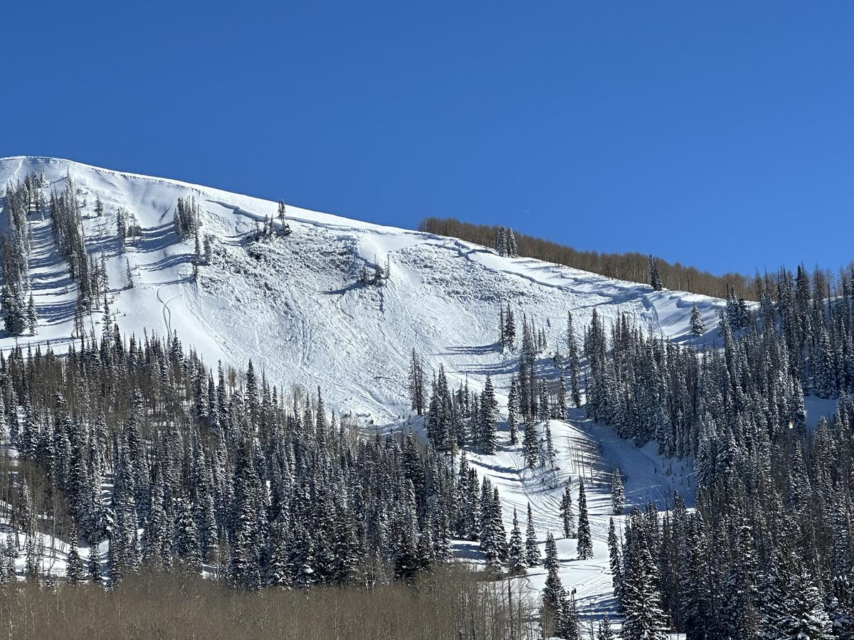
Today the avalanche danger remains CONSIDERABLE near and above treeline on west, north, east, and southeast facing slopes where a rider can trigger a large avalanche breaking on a persistent weak layer.
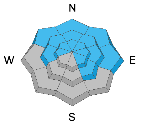
A MODERATE danger exists below treeline and on south and southwest facing slopes.
Avalanche activity is the clearest sign of unstable snow. Even though the odds of triggering an avalanche on buried weak layers are going down, the ability of these layers to fracture means conditions remain dangerous. Conditions are also tricky because you may see multiple sets of tracks on a slope before it avalanches, and some slopes may not avalanche at all while others will.
Low
Moderate
Considerable
High
Extreme
Learn how to read the forecast here
Weather and Snow
This morning, temperatures are in the mid-teens F (about 15 degrees warmer than yesterday morning). Winds blew from the north yesterday but are now mostly blowing from the west 10-15 mph at upper elevations; however, rime on the weather stations may mean these recorded wind speeds are slower than what's actually happening.
Today will be clear and sunny with temperatures warming quickly into the upper 20s and low 30s F. Winds will continue from the west and should increase this afternoon on the north slope of the Uintas where they could blow 20 mph.
Snow coverage is excellent with soft, dry powder on shady slopes and crusted snow on sunny slopes that should become wet again today.
Total snow depths/total water at Uinta SNOTEL sites:
Chalk Creek #1 (9,171') - 57"/13.8"
Hayden Fork (9,130') - 46"/11.4"
Trial Lake (9,992) - 70"/15.3
Wolf Creek Peak (9,796) - 64"/13.9
Currant Creek (7,915') - 41"/9.5"
Strawberry Divide (8,123') - 52"/14.4"
Recent Avalanches
Craig spotted a good-sized avalanche breaking at the ground yesterday triggered by two riders trespassing on private land (photo below). Also, yesterday in Little Cottonwood Canyon, a skier was severely injured and had to be rescued by helicopter. Read the harrowing account from both the injured skier and other person who risked their life to help them HERE.

For more Uinta observations and recent avalanche activity click HERE.
Ad
Avalanche Problem #1
Persistent Weak Layer
Type
Location
Likelihood
Size
Description
Yesterday's snowmobile triggered avalanche clearly shows the types of large, hard slab avalanches that can fracture on buried persistent weak layers today. Most steep slopes have avalanched naturally at least once or twice this winter leaving behind a complex mix of weak layers still capable of producing an avalanche. And just under the new snow from the last week of snowfall, I found buried surface hoar on Friday above Smith and Morehouse reservoir. It may not be widespread but is worth looking for.
Besides avalanche activity, the snowpack continues to speak to us saying it can produce avalanches. There have been reports of collapsing by three different groups near Boundary Creek (1, 2, 3). And other riders have told me they experienced widespread collapsing in rocky areas. These weak layers exist at all elevations but are most likely to produce slides near and above treeline.
The only solution today is to avoid terrain where these weak layers exist or roll the dice and bet your life. On a positive note - these layers are on the road to recovery in the days ahead. Stay tuned.
Avalanche Problem #2
Wind Drifted Snow
Type
Location
Likelihood
Size
Description
Yesterday's increased winds from the north formed some slabs of wind drifted snow that could still be triggered today. Mike J. observed "widespread wind loading from upslope winds creating large wind drifts in the typically wrong direction." These drifts should be stabilizing; however, the additional loading and stress on buried persistent weak layers discussed above can make larger and much deeper avalanches more likely.
Avalanche Problem #3
Wet Snow
Type
Location
Likelihood
Size
Description
The strong February sunshine will heat up the snow on sunny slopes. I expect mainly pinwheels and roller balls and a few wet loose sluffs mainly near exposed rocks.
Additional Information
The Uinta weather station network was upgraded this summer and all that real-time info is found HERE. Simply click on "western Uinta" tab and then "weather stations" tab.

We are always looking for snow and avalanche observations or just general riding conditions. So... if you see something, say something. You can reach me directly at [email protected] or 801-231-2170.
Also, if you're looking for more avy education opportunities for yourself, your crew, or your club please don't hesitate to reach out to me and we'll find a presentation, class, or clinic for ya!
General Announcements

Issued at 0700 on Monday, February 12th this forecast will be updated by 0700 Tuesday, February 13th, 2024.
This forecast is from the U.S.D.A. Forest Service, which is solely responsible for its content. This forecast describes general avalanche conditions and local variations always occur.