31st Annual Backcountry Benefit - September 12th - Tickets Available Here!

Forecast for the Uintas Area Mountains

Mark Staples
Issued by Mark Staples on
Sunday morning, February 11, 2024
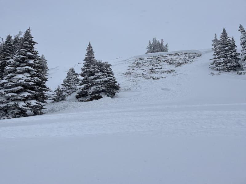
Today the avalanche danger remains CONSIDERABLE near and above treeline on west, north, east, and southeast facing slopes where a rider can trigger a large avalanche breaking on a persistent weak layer.
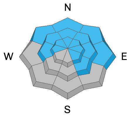
A MODERATE danger exist below treeline and on south and southwest facing slopes.
The snowpack is still adjusting to loading from snowfall from the start of February which contained 3-4 inches of water, a massive load. That snowfall was combined with steady south winds that were perfect for loading northerly facing slopes as well as cross loading west and east facing slopes. Such a huge load of snow added a lot of stress on buried weak layers. The good news is that such a huge load of snow is also insulating those layers and will be helping them become dormant this coming week. Give them time.
Low
Moderate
Considerable
High
Extreme
Learn how to read the forecast here
Weather and Snow
This morning, temperatures are hovering near 0 degrees F. Winds from the north picked up a little overnight and are blowing 25-30 mph at upper elevations.
Today, temperatures should warm quickly under strong sunshine reaching the mid to upper 20s F. Winds will continue from the north but decrease this afternoon to about 10 mph.
Snow conditions are excellent with good coverage and great powder, especially on shady slopes. South facing slopes got warm yesterday and should have an ice crust on them this morning.
Total snow depths/total water at Uinta SNOTEL sites:
Chalk Creek #1 (9,171') - 60"/13.6"
Hayden Fork (9,130') - 49"/11.3"
Trial Lake (9,992) - 73"/15.3
Wolf Creek Peak (9,796) - 66"/13.8
Currant Creek (7,915') - 42"/9.4"
Strawberry Divide (8,123') - 54"/14.4"
Recent Avalanches
There were two massive slides in the Wasatch Range worth paying attention to. One on Gobblers Knob 5' deep and 400' wide, and another on Cardiac Ridge 3.5' deep and 350' wide.
Craig spotted a recent avalanche yesterday from Feb 7th that he describes in the video below. On Thursday a group remotely triggered an avalanche (from a distance). Not a huge slide, but the avalanche broke on weak snow close to the ground on a steep, heavily wind loaded, rocky slope in the Currant Creek Peak area. Photo below (W. Taylor).

For more Uinta observations and recent avalanche activity click HERE.
Ad
Avalanche Problem #1
Persistent Weak Layer
Type
Location
Likelihood
Size
Description
Persistent weak layers of faceted snow are still lurking in the snowpack and are now buried quite deeply. People continue to report lots of collapsing, mainly in rocky areas which is a red flag.
Many slopes avalanched during big storms in mid January on facets from dry weather in late December as well as old faceted layers of November snow. A complex mix of layers remains in most avalanche starting zones. Additionally, a few weak layers formed during very warm weather at the end of January that were buried by the recent storms. I found a layer of buried surface hoar (photo below) above Smith and Morehouse Reservoir on Friday. Yesterday on the north slope of the Uintas near Boundary Creek, Ted easily found these layers when digging a snow pit and his "shovel just plunged into quite weak sugary faceted snow." Nearby Mike Wessler reported loud, booming collapses.
Overall, these weak layers are gaining a little strength each day and will become dormant soon, but I'm not ready to trust them with my life yet. Steep, rocky slopes are the most likely places to trigger a hard slab avalanche that could break 3-5 feet deep.
Avalanche Problem #2
Wet Snow
Type
Location
Likelihood
Size
Description
Air temperatures will stay cold today, but the strong February sunshine will heat up the snow on sunny slopes. I expect mainly pinwheels and roller balls and a few wet loose sluffs mainly near exposed rocks.
Additional Information
The Uinta weather station network was upgraded this summer and all that real-time info is found HERE. Simply click on "western Uinta" tab and then "weather stations" tab.

We are always looking for snow and avalanche observations or just general riding conditions. So... if you see something, say something. You can reach me directly at [email protected] or 801-231-2170.
Also, if you're looking for more avy education opportunities for yourself, your crew, or your club please don't hesitate to reach out to me and we'll find a presentation, class, or clinic for ya!
General Announcements

Issued at 0700 on Sunday, February 11th this forecast will be updated by 0700 Monday, February 12th, 2024.
This forecast is from the U.S.D.A. Forest Service, which is solely responsible for its content. This forecast describes general avalanche conditions and local variations always occur.