March Kicks Off Our Spring Campaign- Donate Now to Support Forecasting

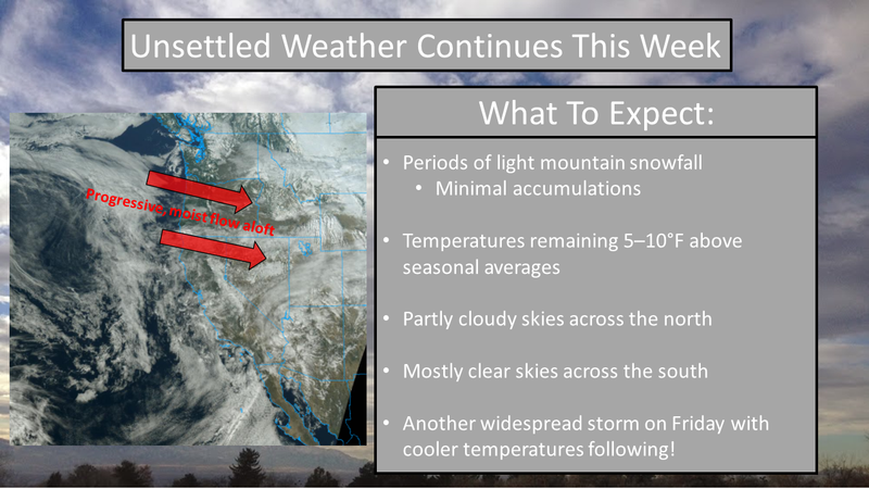
Forecast for the Uintas Area Mountains

Craig Gordon
Issued by Craig Gordon on
Wednesday morning, February 10, 2021
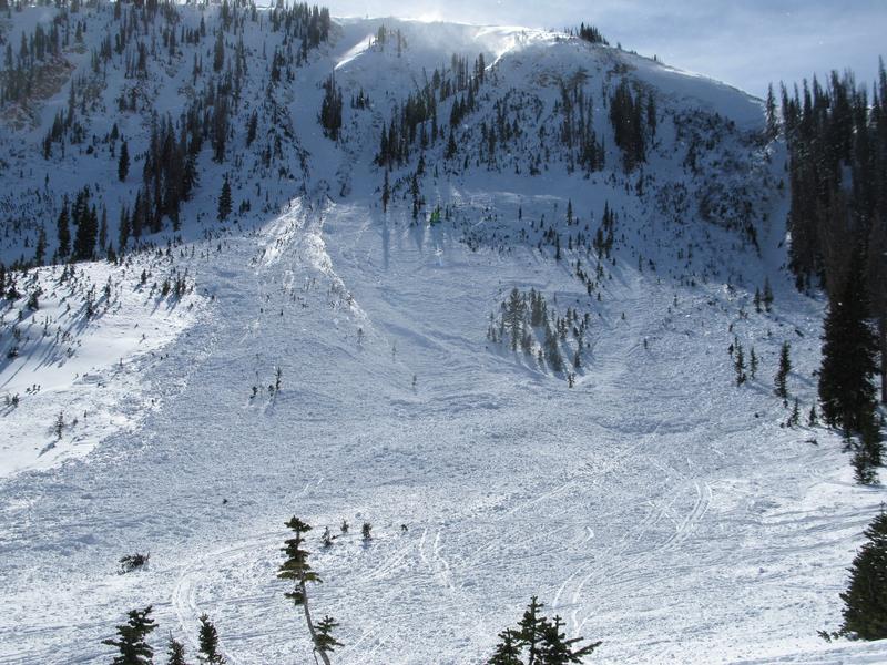
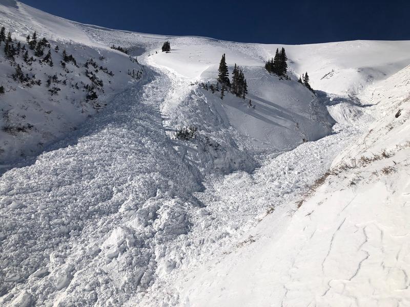
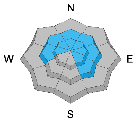
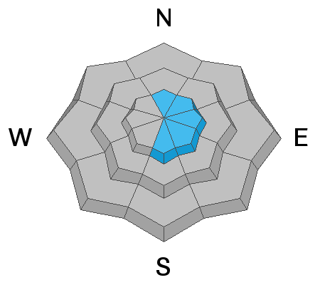
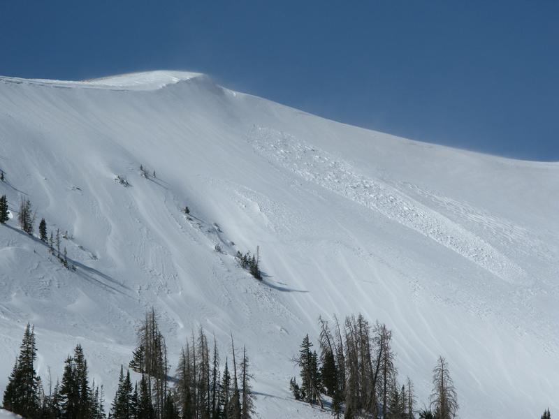
CONSIDERABLE avalanche danger is found in the wind zone at and above treeline. Human triggered avalanches are LIKELY especially on slopes facing the north half of the compass and particularly those with an easterly component to their aspect.

Near treeline in mid elevation terrain, human triggered avalanches are possible on steep wind drifted slopes and the avalanche danger is MODERATE.
Here's your exit strategy- Low avalanche danger is found on lower and mid elevation terrain, especially slopes facing the south half of the compass and slopes less than 30 degrees in steepness, but you need to make sure there's no steep terrain above or adjacent to where you're riding. And remember- the Uinta's have lots of fun rolly-polly terrain and big open meadows.
Low
Moderate
Considerable
High
Extreme
Learn how to read the forecast here
Special Announcements
We are filled with grief to report four avalanche fatalities yesterday in the Wilson Glade of upper Mill Creek Canyon. The avalanche involved two separate parties. Our deepest condolences go out to the friends and families involved. Our deepest gratitude to the many members of SL County SAR, Wasatch Backcountry Rescue, Intermountain Lifeflight, the United States Forest Service, Utah Dept of Public Safety, along with Brighton, Solitude and Alta Ski Patrols for providing resources and support during this tragic accident. The avalanche path is on north facing terrain at 9800'. The avalanche is estimated to be 2-3' deep and at least 250' wide. Our preliminary report will be continually updated over the next several days

Weather and Snow
Nowcast-
A moist westerly flow over the region ushers in mostly cloudy skies and scattered snow showers. So far about a trace, perhaps even a few traces have fallen. Winds finally calmed down yesterday after sunset and currently clock in at 15-25 mph along the high ridges. Temperatures register in the teens and low 20's. Riding and turning conditions vastly improved with last weeks storm, but average snow depths clock in around 4' of total settled snow and the range looks more like early January.
Forecast-
Expect mostly cloudy skies with scattered snow showers tapering off by mid-morning. West and northwest winds remain reasonable, blowing in the teens and mid 20's. High temperatures climb into the low 30's
Futurecast-
Thursday is the warm before the storm. Look for increasing clouds and winds as a warm and moist Pacific storm system sets its sights on the state. Snow develops from north to south late Thursday, with the strongest portion of the storm crossing the mountains early Friday morning. Looks like a good shot of snow and water with about a foot expected to stack up by late in the day.

Looking for real-time temps, snow, or wind?
Click here and then on the "western Uinta" tab for western Uinta specific, weather station network.
Recent Avalanches
Many large avalanches were triggered across the range this weekend including a near miss at Moffit Peak (top image) and amazing viddy HERE. Along with an intentionally triggered slide in upper Weber Canyon (bottom image).

More obs and trip reports found here.
Ad
Avalanche Problem #1
Persistent Weak Layer
Type
Location
Likelihood
Size
Description
Once triggered, today's avalanches will break deep and wide, taking out the entire seasons snowpack like Saturday's large avalanche near Moffit Peak which I discusses in the viddy above.
Nothing has changed with the shaky foundation of our snowpack structure, but last weeks storm snow is settling, getting stronger, and becoming more comfortable in its own skin... and that's the good news. But the bad news is, our snowpack is a structural gong show and it just won't magically heal overnight. And without getting all sciencey and snow nerdy with y'all, let's think about it this way... imagine you're building a home with a weak foundation that doesn't get any stronger over time, yet we have to keep on the construction schedule and we keep adding additional, heavier, more dense floors on top - eventually the whole structure collapses and if we're underneath, it crashes down on top of us. Last weeks new snow and wind drifted snow added more floors to this unstable, house of cards structure. And while many slopes avalanched naturally, there's still many more that just wait for a trigger like us to roll along and knock the legs out from underneath.
THIS AVALANCHE PROBLEM IS TRICKY - Tracks on a slope do not mean it's safe. As a matter of fact, as the snow gains strength it allows us to get well out onto the slope before it fails and it may be the 2nd, 3rd, or even 10th person on a slope who triggers the slide.
And here's where the rubber hits the road... recent avalanche activity shows us that avalanches are unmanageably large and breaking to the dirt!

I describe this set up in the video below
Avalanche Problem #2
Wind Drifted Snow
Type
Location
Likelihood
Size
Description
The image above illustrates how recent strong winds deposited fresh drifts well off the ridges, loading snow lower downslope than we expect to see.
Both new and old wind drifts lurk on the leeward side of upper elevation ridges and around terrain terrain features like chutes and gullies.
The main issue with slabs of wind drifted snow is... they increase the load and stress on buried persistent weak layers which elevates the likelihood of triggering a slide. Once triggered, a small wind drift can easily get out of hand if it breaks into weaker layers of snow, buried deeper in the snowpack. Your best strategy is to simply avoid fat rounded pieces of snow, especially if they feel or sound hollow like a drum.
Additional Information
On Thursday, Andy, Joey, and I setup the avalanche beacon training park at the Nobletts trailhead. There is also one at the Bear River Trailhead that Ted Scroggin set up. These beacon parks have pre-buried beacons that you can turn on/off with a control panel. It only takes a few minutes to refresh your beacon searching skills at one of these places.
I will update this forecast by 7:00 AM tomorrow, Wednesday, February 11th.
Your observations are import, so please let me know what you're seeing... click HERE and contribute to this amazing community based program
General Announcements
If you see or trigger an avalanche or just wanna let me know what you're seeing you can reach me directly at 801-231-2170 or [email protected]
This forecast is from the U.S.D.A. Forest Service, which is solely responsible for its content. This forecast describes general avalanche conditions and local variations always occur.