Forecast for the Uintas Area Mountains

Craig Gordon
Issued by Craig Gordon for
Tuesday, February 1, 2022
Today, you'll find LOW avalanche danger and human triggered avalanches are unlikely on all aspects and elevations. Sure, most terrain is good to go... but remember, if you're stepping into a big, committing line take a minute and think about the consequences of triggering even a small avalanche that could knock you off your feet and instantly ruin your day.
Low
Moderate
Considerable
High
Extreme
Learn how to read the forecast here
Weather and Snow
NOWCAST-
As some slept and others worked, a dry cold front slid through the region and temperatures cratered into negative territory overnight. Current ridgetop temperatures register at -2 degrees and with westerly winds blowing in the teens, windchill clocks in at -23 degrees... ouch. Riding and turning conditions are a mixed bag, but somewhere in between the old tracks and varying degrees of suncrust and wind funk, you can still find swaths of soft snow on mid elevation shady slopes.
FORECAST-
Expect clear skies with temperatures barely cracking into the teens and low 20's. Winds calm down, remaining light and northwesterly, blowing 10-20 mph near the high peaks. Overnight lows crash to near zero degrees.
FUTURECAST-
A slightly stronger, yet still moisture starved system is on tap for Wednesday, bringing the chance for a few snow showers, but not much in the way of accumulating snow.

Looking for real-time temps, snow, or wind?
Click HERE and then on the "western Uinta" tab for western Uinta specific, weather station network.
Recent Avalanches
No significant avalanche activity to report

Click HERE for a list of recent avalanches.
A list of all other observations is found HERE

Your input is vital and we're interested in what you're seeing. Please contribute to this great community resource and go here to fill out an observation.
Ad
Avalanche Problem #1
Normal Caution
Type
Location
Likelihood
Size
Description
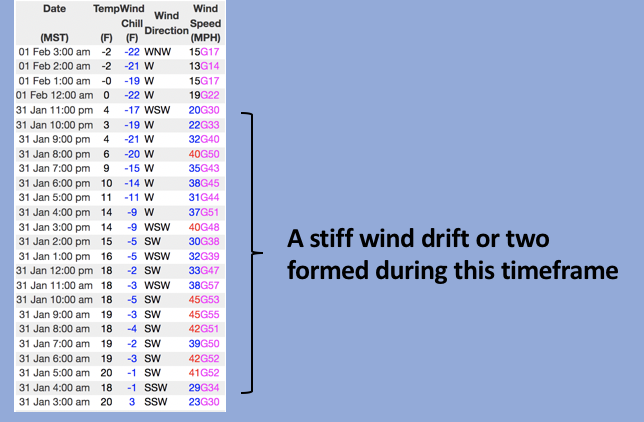
Above, a 24 hour data dump from Windy Peak (10,662') clearly shows yesterdays strong ridgetop winds along with the cold front timing.
While there's not much snow to blow around, it never ceases to amaze me how winds can rip through terrain features and whip up just enough snow to create stiff wind drifts on the leeward side of upper elevation ridges. And while not particularly widespread, I suspect yesterdays wind also created a rogue pocket or two in the wind zone above treeline, cross-loading a random chute or gully feature. Sure, you'd really have to go out of your way to trigger an avalanche today, but it's certainly not impossible.
So, what do we do with generally stable snow and Green Light conditions? Of course, we set our sights on big objectives and tagging big terrain. However, before diving head first, pump the brakes for a second or two and evaluate each slope on an individual basis. If I'm in steep, committing terrain, I consider the consequences of triggering even a small slide which could knock me off me feet and instantly ruin my day.
Snow geek-speak-
Not much going on at the moment, but looking into the past and present helps us look into the future in terms of snow stability and right now we're focusing on snow surface temperatures which ricochet all over the map. Cold temperatures at night and warm temperatures during the day create very weak, faceted grains close to the snow surface and this is what we call Near Surface Facets (NSF). The NSF was capped and preserved by last Tuesday's few inches of snow. Mark found it last week around Soapstone... captured in the image above.
Additional Information
While we're waiting patiently for winter to return from its hiatus, take a few minutes and visit one of our beacon parks and test your rescue skills. Ted installed a Beacon Basin at the Bear River Trailhead and there's another park found at the northeast corner of the Nobletts Trailhead.
Your observations are important, so please let me know what you're seeing... click HERE and contribute to this amazing community based program
General Announcements
The information in this forecast expires 24 hours after the day and time posted, but will be updated by 07:00 Wednesday February 2nd.
Before it gets too crazy, now is the time to book an avalanche awareness presentation for your group, club, or posse. You can reach me directly at 801-231-2170 or [email protected]
This forecast is from the U.S.D.A. Forest Service, which is solely responsible for its content. This forecast describes general avalanche conditions and local variations always occur.