Donate to Our Spring Campaign or Bid on our Spring Auction to Support Forecasting

Forecast for the Uintas Area Mountains

Craig Gordon
Issued by Craig Gordon on
Friday morning, December 27, 2019
In the wind zone at mid and upper elevations, MODERATE avalanche danger exists for both new and old snow issues. Primarily found on steep slopes facing the north half of the compass, human triggered avalanches initiated on fresh wind drifted slopes and then breaking to old snow near the ground are POSSIBLE, particularly in rocky terrain harboring weak, pre-existing, early season snow.
Lose a little elevation and you lose much of the problem. Wind sheltered, low and mid elevation terrain and big open meadows with no steep slopes above or adjacent to where you're riding generally offers LOW avalanche danger and human triggered avalanches are unlikely.
Low
Moderate
Considerable
High
Extreme
Learn how to read the forecast here
Special Announcements
Huge thanks to Andy Nassetta and Kyle Mays for their Herculean efforts Tuesday installing both the Are You Beeping sign and Beacon Basin at Nobletts... you guys rock and your hard work is deeply appreciated by everyone in our mountain community.
Weather and Snow
Currently-
Skies cleared overnight and temperatures cratered into the single digits where they sit early this morning. Southeast winds are generally light, blowing 10-20 mph, even along the high peaks. The Christmas storm was good to us, delivering 10" of medium density snow, which goes a long way to help cushion hard, old snow surfaces. Mid elevation wind sheltered slopes offer soft, creamy snow. Total snow depths average just over three feet and the range has excellent early season coverage.
Uinta weather network info is found here. Simply click on the Western Uinta tab.
For today-
Expect light winds, variable cloud cover, and cold temperatures with highs climbing into the low 20's. Northerly winds increase later today and remain a nuisance tonight as colder air pours into the area from the north and northwest. Scattered light snow showers start to develop late tonight and linger into Saturday morning.
Future cast-
The pattern remains active with another shot of light snow Sunday. The potential is encouraging for a decent storm around New Years.
The snow is cold and light with riding and turning conditions all time right now. And while not widespread, an observation from Weston D yesterday noted sunny slopes taking on a bit of heat with damp sloughing easily initiated on sustained, steep, slopes.
Meanwhile, back on the shady slopes... Micheal J found cold dry snow and an excellent trip report found
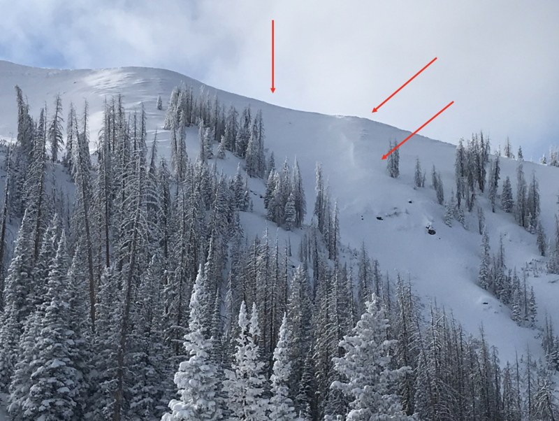
 here.
Recent Avalanches
No significant new avalanche activity to report for nearly a week from Uinta world, but the viddy below captured by Matt Baydala in Dutch Draw Wednesday is quite compelling.
To view trip reports and recent avalanche activity, simply click here.
Ad
Avalanche Problem #1
Persistent Weak Layer
Type
Location
Likelihood
Size
Description
The biggest clue to avalanches is.... avalanches! Occurring during the mid December storm, sure it's old news, but the slide in the image above, to the southeast of Tower Montain, clearly illustrates the type of avalanche we're dealing when we talk about a persistent weak layer.
But wait.... there's more!
First, the good news-
Our snowpack is slowly healing and both snow structure and lack of avalanche activity reveals why it's been a over week since we've seen or heard of any avalanches failing on weak, old snow layers near the ground.
But second and most importantly...
There's a persistent weak layer near the ground, and once initiated, avalanches have a distinct possibility of breaking deeper and wider than you might expect.
Personally, I don't entirely trust anything in the snowpack I can't manage, so I'm going to continue avoiding terrain that harbors questionable snowpack structure. Of course the usual suspects come to mind... steep, rocky, upper elevation slopes facing the north half of the compass is bulls-eye terrain and should be considered suspect. With all the great coverage across the range and so many other riding options, there's no reason to roll the dice or pull on the dogs tail.
Avalanche Problem #2
Wind Drifted Snow
Type
Location
Likelihood
Size
Description
Currant Creek Peak in the image above, along with arrows indicating recent winds, reveals the kind of terrain where you're most likely to find a fresh wind drift today. While mostly manageable in size, if you're getting into high alpine terrain, today's wind slabs might break a bit wider and deeper than you'd expect and could boss you around. Found along the leeward side of upper elevation ridges and around terrain features like chutes and gullies, your best bet for avoidance is to simply steer clear of any fat, rounded piece of snow, especially if it sounds hollow like a drum. In addition, look for shooting cracks in the snow which are sure signs of unstable conditions.
Additional Information
Thanks to the generous support of our Utah ski resorts and Ski Utah, we have discount lift tickets available. All proceeds support the UAC. Get your tickets HERE.
Get one of these cool t-shirts to support the UAC and other avalanche centers across the U.S. INFO
General Announcements
The information in this forecast expires in 24 hours, but will be updated by 7:00 AM Saturday Dec. 28th.
This forecast is updated daily by 7:00 AM.
In the mean-time, if you see or trigger an avalanche or just wanna let me know what you're seeing you can reach me directly at 801-231-2170
It'll be a minute or two before we're riding, but while you're waiting....
This is a great time of year to schedule one of our free avy awareness presentations.
You can email me directly [email protected]
The information in this forecast is from the US Forest Service which is solely responsible for its content.