Forecast for the Uintas Area Mountains

Mark Staples
Issued by Mark Staples for
Friday, December 24, 2021
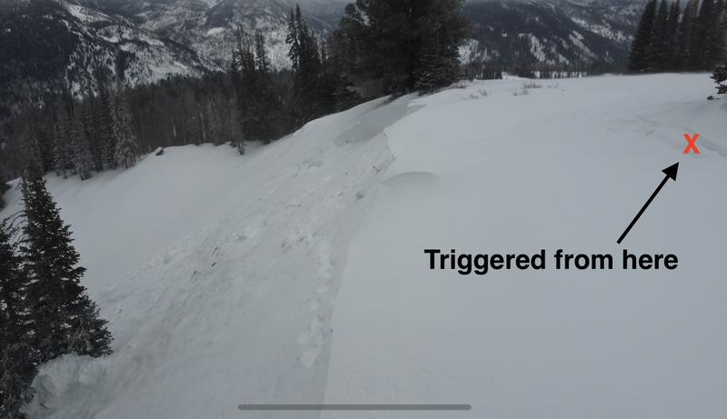
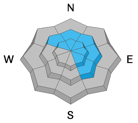
Very dangerous avalanche conditions exist near and above treeline in the Uinta Mountains where the avalanche danger is HIGH. Both natural and human-triggered avalanches are likely. Very dense, heavy snow combined with strong winds has overloaded a fragile snowpack. Below treeline, human triggered avalnaches are likely, and the avalanche danger is CONSIDERABLE.

This storm and these avalanche conditions are very dangerous and very serious. Give yourself a wide safety margin today and avoid avalanche terrain. Go to rolling meadows less than 30 degrees in steepness with no steep terrain above or near them. Fortunately, the Uinta mountains have plenty of safe terrain where you can avoid avalanches.
Low
Moderate
Considerable
High
Extreme
Learn how to read the forecast here
Avalanche Warning
AN AVALANCHE WARNING HAS BEEN ISSUED FOR THE MOUNTAINS OF MUCH OF THE STATE OF UTAH, INCLUDING THE WASATCH RANGE...BEAR RIVER RANGE...UINTA MOUNTAINS...THE MANTI-SKYLINE...THE FISH LAKE REGION…PAHVANTS…TUSHARS…AND THE CEDAR CITY AREA MOUNTAINS.
HEAVY DENSE SNOWFALL AND STRONG WINDS WILL LIKELY CREATE VERY DANGEROUS AVALANCHE CONDITIONS. BOTH HUMAN TRIGGERED AND NATURAL AVALANCHES ARE LIKELY. STAY OFF OF AND OUT FROM UNDER SLOPES STEEPER THAN 30 DEGREES.
Special Announcements
Avalanche conditions are very dangerous across most of the State of Utah as discussed by our staff in the video below -
Weather and Snow
NOWCAST-
As of 4 a.m. about a foot of VERY dense snow has fallen containing 1.0-1.7 inches of water, and more snow is coming. Temperatures range from the mid 20s to mid teens F. Winds yesterday were blowing 50 mph gusting to 70 mph from the south-soutwest. This morning winds are blowing 25 mph from the west-southwest.
FORECAST-
Snowfall will continue all day. Temperatures should hold steady, and winds may increase some this afternoon and blow 30-40 mph from the west-southwest. By tomorrow morning, the western Uinta Mountains could receive about another foot of snow.
FUTURECAST-
There is a bit of a lull in the snowfall tomorrow, but heavier snowfall should kick in again Sunday morning. Very cold air will descend over the area Sunday afternoon with mountain temperatures in the single digits F.
Looking for real-time temps, snow, or wind?
Click HERE and then on the "western Uinta" tab for western Uinta specific, weather station network.
Recent Avalanches
The snowpack has been giving a clear warning message. I remotely triggered an avalanche above Smith and Morehouse Reservoir yesterday on a slope being loaded by strong winds from the south.
A list of all other observations is found HERE

Observations, trip reports, and avalanches found here.
Your input is vital and we're interested in what you're seeing. Please contribute to this great community resource and go here to fill out an observation.
Ad
Avalanche Problem #1
Persistent Weak Layer
Type
Location
Likelihood
Size
Description
Slab avalanches will break on a persistent weak layer of old snow near the ground today.
  • They can be 2-4 feet deep or more in heavily wind loaded areas.
  • They can break hundreds of feet wide
  • You don't have to be on a slope to trigger one of these avalanches.
  • You can trigger them from flat terrain below steep slopes.
There is plenty of safe terrain in the Uinta Mountains, but the key is to avoid these avalanches is to avoid being under or anywhere near slopes steeper than 30 degrees.
Avalanche Problem #2
Wind Drifted Snow
Type
Location
Likelihood
Size
Description
Winds from the south blew 50-70 mph yesterday afternoon. These winds drifted snow mostly on slopes that have a persistent weak layer of sugary facets near the ground. The problem with these wind slabs is that they will make avalanches breaking on the facets larger, deeper, and more deadly. Avoid any steep slope, and especially avoid any slope with obvious wind drifting where avalanches are very likely to occur.
Avalanche Problem #3
New Snow
Type
Location
Likelihood
Size
Description
On slopes that don't have wind drifted snow and don't have old facets near the ground, the new snow alone may produce soft slab avalanches. Subtle variations in the new snow like density changes can create a temporary weak layer. Fortunately these instabilities can be short lived, but they remain a concern as long as it is snowing.
Additional Information
Your observations are important, so please let me know what you're seeing... click HERE and contribute to this amazing community based program
General Announcements
The information in this forecast expires 24 hours after the day and time posted, but will be updated by 07:00 Friday December 24th.
Before it gets too crazy, now is the time to book an avalanche awareness presentation for your group, club, or posse. You can reach me directly at 801-231-2170 or [email protected]
This forecast is from the U.S.D.A. Forest Service, which is solely responsible for its content. This forecast describes general avalanche conditions and local variations always occur.