Forecast for the Uintas Area Mountains

Craig Gordon
Issued by Craig Gordon for
Tuesday, December 21, 2021
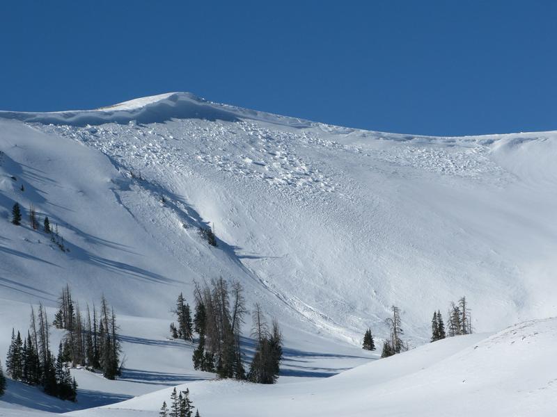
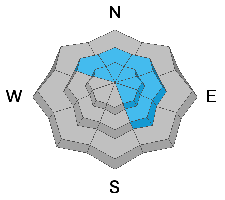
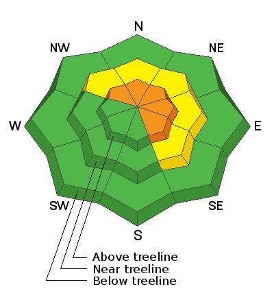
A CONSIDERABLE avalanche danger exists on steep, wind drifted, upper elevation slopes, particularly those facing the north half of the compass and human triggered avalanches are LIKELY. Once initiated, even a small slide will quickly get out of hand, especially if it breaks to old, October snow. It'll be packing a punch and it's gonna boss you around.
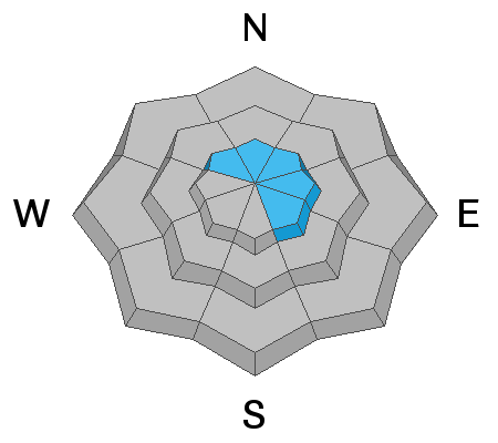
You'll find MODERATE avalanche danger at mid elevations. While slightly more manageable, steep, shady terrain remains suspect and human triggered avalanches are POSSIBLE.
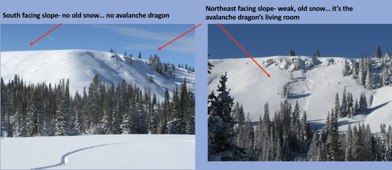
I know you're looking to avoid the avalanche dragon today, so the ticket is to simply switch aspect or lose elevation and set your sights on terrain that was bare prior to last weeks big storm. You'll find generally LOW avalanche danger on slopes with these characteristics.
Low
Moderate
Considerable
High
Extreme
Learn how to read the forecast here
Special Announcements
Just 'cause you can see it from the road doesn't necessarily make it safe and Wolf Creek Pass is a perfect example. The weekend crew did it right by stacking tracks in the sunny bowl with no old snow issues, while avoiding the temptation to dive into the steep, shady bowl where the dangerous Avalanche Dragon or Persistent Weak Layer (PWL) is found... nice work!
Weather and Snow
NOWCAST-
High clouds drifted into the region overnight, keeping temperatures rather mild and currently registering in the upper teens and mid 20's. Southwest winds bumped into the 20's and low 30's for a short time Monday, but relaxed overnight, backing off into the teens. Riding and turning conditions continuing improving with each storm and now we've got a respectable base which averages close to 30" in most upper elevation areas.
FORECAST-
High pressure camps out for one more day giving us mostly sunny skies with temperatures climbing into the mid and upper 30's. Southwest winds remain rather well behaved and blow in the mid 20's along the ridges. Overnight temperatures dip into the low to mid 20's.
FUTURECAST-
A change in the weather materializes late Wednesday as a weak system clips northern Utah. A more robust series of storms is still on tap beginning Thursday with best chances for significant snow slated for late Thursday into Friday.
Looking for real-time temps, snow, or wind?
Click HERE and then on the "western Uinta" tab for western Uinta specific, weather station network.
Recent Avalanches
Ted and I rolled into Upper Moffit Basin yesterday to work on a weather station and discovered this monster avalanche that peeled off Windy Peak sometime late Saturday. Breaking 10' deep and 600' wide... an eye-catcher for sure. In addition, there's no shortage of both human triggered and natural avalanches from last weeks storm and an updated list is found HERE

Observations, trip reports, and avalanches found here.
Your input is vital and we're interested in what you're seeing. Please contribute to this great community resource and go here to fill out an observation.
Ad
Avalanche Problem #1
Persistent Weak Layer
Type
Location
Likelihood
Size
Description
On Saturday, Andy and Joey stomped around the south half of the range and have an excellent observation from their travels found HERE. Above, Andy pretty much sums up what's going on with our dangerous, strong snow over weak snow setup.
Let's face it, our snowpack is deceptively tricky because a strong, cohesive slab rests on fragile, old October snow... or what we call a persistent weak layer (PWL). This is always a dangerous combination in our mountains because the stronger snow feels bomber under our skis, board, or sled. This setup allows us to get well out onto the slope before we kick the legs out from underneath, the weak layer fails (usually around a bush or rock we can't see under the snow), the avalanche breaks above us, and now the entire seasons snowpack crashes down on top of us. The most likely place to encounter this avalanche dragon is on steep, mid and upper elevation slopes facing the north half of the compass, especially terrain that harbors old, October snow.
But here's the good news... it doesn't mean we can't ride. It does mean we need to avoid terrain with these characteristics. You can have a blast in a big open meadow or on low angle terrain with no steep slopes above or adjacent to you... done and done :)
Avalanche Problem #2
Wind Drifted Snow
Type
Location
Likelihood
Size
Description
While not widespread, a few lingering drifts are found along the leeward side of upper elevation ridges. It's pretty straight forward so let's not overthink this one. Keep it simple and simply avoid any steep slope facing the north half of the compass, especially if it appears fat and rounded or sounds hollow like a drum. And remember- any avalanche that initiates in the new snow may break deeper and wider as it crashes down on the slope below, creating a larger slide than you might expect.
Additional Information
Your observations are important, so please let me know what you're seeing... click HERE and contribute to this amazing community based program
General Announcements
The information in this forecast expires 24 hours after the day and time posted, but will be updated by 07:00 Wednesday December 22nd.
Before it gets too crazy, now is the time to book an avalanche awareness presentation for your group, club, or posse. You can reach me directly at 801-231-2170 or [email protected]
This forecast is from the U.S.D.A. Forest Service, which is solely responsible for its content. This forecast describes general avalanche conditions and local variations always occur.