Donate to Our Spring Campaign or Bid on our Spring Auction to Support Forecasting

Forecast for the Uintas Area Mountains

Craig Gordon
Issued by Craig Gordon on
Saturday morning, December 21, 2019
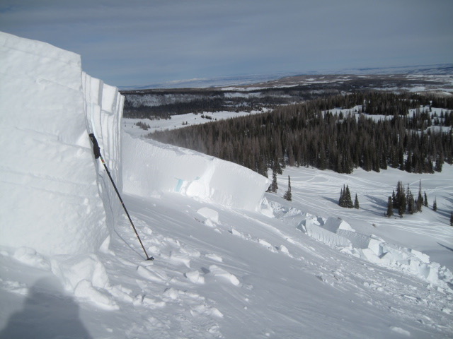
Any avalanche that breaks to old snow near the ground WILL quickly get out of hand, resulting in a deep, dangerous slide.
UNPREDICTABLE -
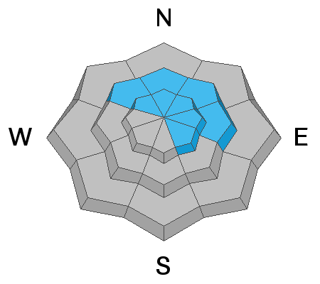
Making up a small portion of the terrain available to ride in today, in the wind zone at mid and upper elevations, a MODERATE avalanche danger is found on steep slopes facing the north half of the compass, especially those with an easterly component to their aspect. Human triggered avalanches breaking to old snow near the ground are POSSIBLE, particularly in rocky terrain harboring weak, pre-existing, early season snow.
MORE PREDICTABLE-
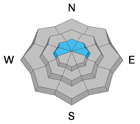
New and old wind drifts are most prevalent along the leeward side of upper elevation ridges and around terrain features like chutes and gullies where MODERATE avalanche danger is found and human triggered avalanches are POSSIBLE.
Wind sheltered, low and mid elevation terrain and big open meadows with no steep slopes above or adjacent to where you're riding generally offers LOW avalanche danger and human triggered avalanches are unlikely.
Low
Moderate
Considerable
High
Extreme
Learn how to read the forecast here
Special Announcements
In partnership with Brighton Ski Patrol I'll be giving a Brighton Basin backcountry specific avy awareness presentation. Hope to see y'all later today!
Weather and Snow
Currently-
Skies are partly cloudy and temperatures in the mid to upper 20's. Southerly winds began bumping into the 30's along the high peaks right around midnight. No new snow has fallen for a week, but with total snow depths averaging just over three feet, the range has excellent early season coverage. Riding and turning conditions are quite good and low angle, wind sheltered slopes are the ticket.
For today-
A beautiful day is on tap. Expect mostly sunny skies with temperatures rising in the mid and upper 30's. Southwest winds will be a nuisance along the high peaks as they continue ramping up throughout the day, blowing in the 30's and 40's by dinnertime.
Future cast-
Southwest winds increase across the area through late Sunday. Periods of light snow are expected beginning Christmas Eve Day, with additional rounds of snow and colder temperatures through the remainder of the week.
Recent Avalanches
No significant new avalanche activity to report since midweek.
Ted was near Double Hill Wednesday and spotted this connected hard slab on a heavily wind loaded, northeast facing slope on the north end of Double Hill. Breaking 3'-5' deep and about 150' wide, this avalanche failed on weak, sugary snow near the ground. The jury is still out, but nearby sled tracks suggest this slide was triggered from a distance. Ted knows the Uinta's better than anyone and he's an integral part of our avalanche forecast team. Ted's insight and very informative report is found here.
Recent avalanche activity and trip reports are found here.
Ad
Avalanche Problem #1
Persistent Weak Layer
Type
Location
Likelihood
Size
Description
The snowpack continues gaining strength and stability tests suggest the pack is getting comfortable in its own skin. And while it's been a few days since we saw or heard of any avalanche activity failing on weak, old snow layers near the ground, I still don't think we're out of the woods quite yet. You see, persistent weaknesses in the snowpack linger for long periods of time and we need to consider not only the snow we're riding in, but also the snow we're riding on. And when I look at the structure (strong snow over weak snow) I still don't trust it.
So... the kind of terrain I'm avoiding is the kind of terrain where I'm most likely gonna find strong snow on weak snow and that's steep, rocky, upper elevation slopes, especially those facing the north half of the compass.
It's not a widespread problem and it's not gonna be in your face. But once triggered, avalanches can break deep and wide, resulting in a dangerous slide that will get quickly out of hand. No matter how you cut it, it's not the type of avalanche problem that I want to tangle with or try to outsmart... patience and avoidance are the key. The range is white, the early season coverage is remarkable and with all the great riding options, there's no reason to pull on the dogs tail.
I'm simply gonna ride low angle terrain in the sun and avoid being on or under steep, wind drifted slopes.
Avalanche Problem #2
Wind Drifted Snow
Type
Location
Likelihood
Size
Description
There's not a tremendous amount of snow available to blow around, but the Uinta's are a huge range and I bet there's a few fresh drifts forming along the leeward side of upper elevation ridges and around terrain features like chutes and gullies. Most of today's drifts are stubborn and not particularly sensitive to our additional weight, but any drift triggered may break slightly deeper and wider than you might expect. So, your best bet for avoidance is to simply steer clear of any fat, rounded piece of snow, especially if it looks chalky or sounds hollow like a drum. In addition, look for and listen to clues like whoomphing sounds or shooting cracks in the snow which are sure signs of unstable conditions.
Additional Information
Thanks to the generous support of our Utah ski resorts and Ski Utah, we have discount lift tickets available. All proceeds support the UAC. Get your tickets HERE.
Get one of these cool t-shirts to support the UAC and other avalanche centers across the U.S. INFO
General Announcements
The information in this forecast expires in 24 hours, but will be updated by 7:30 AM Sunday Dec. 22nd.
This forecast is updated daily by 7:30 AM.
In the mean-time, if you see or trigger an avalanche or just wanna let me know what you're seeing you can reach me directly at 801-231-2170
It'll be a minute or two before we're riding, but while you're waiting....
This is a great time of year to schedule one of our free avy awareness presentations.
You can email me directly [email protected]
The information in this forecast is from the US Forest Service which is solely responsible for its content.