Donate to Our Spring Campaign or Bid on our Spring Auction to Support Forecasting

Forecast for the Uintas Area Mountains

Craig Gordon
Issued by Craig Gordon on
Saturday morning, December 14, 2019
HEADS UP... dangerous avalanche conditions continued evolving overnight.
UNPREDICTABLE-
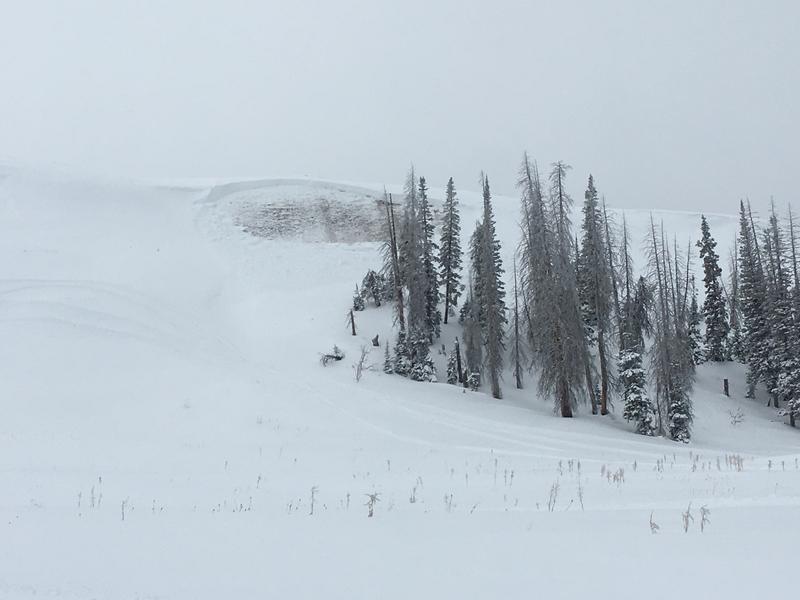
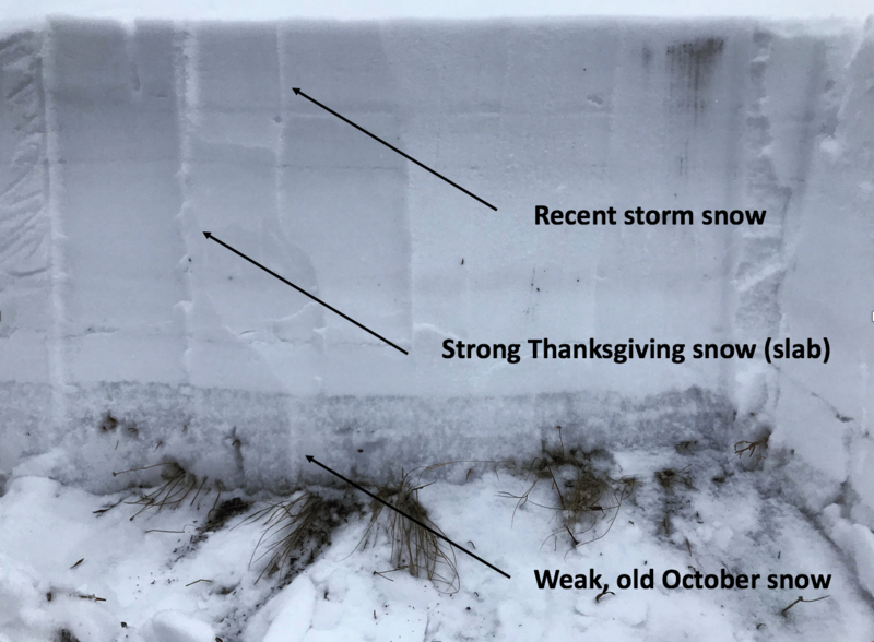
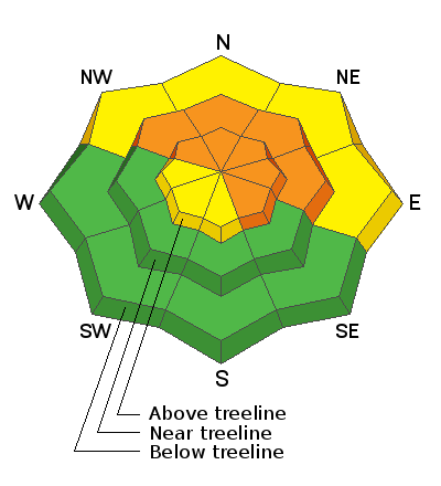
In the wind zone at mid and upper elevations, CONSIDERABLE avalanche danger exists on steep slopes facing the north half of the compass, especially those with an easterly component to its aspect. Human triggered avalanches are LIKELY, particularly in rocky terrain harboring weak, pre-existing, early season snow near the ground. Remember- any avalanche that breaks to old snow near the ground may quickly get out of hand, resulting in a deep and dangerous slide.
MORE PREDICTABLE-
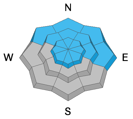
Expect both new and old wind drifts sensitive to our additional weight along the leeward side of mid and lower elevation ridges and around terrain features like chutes and gullies. In terrain with these characteristics you'll find MODERATE avalanche danger and human triggered avalanches are possible. Keep in mind... winds have been all over the map, loading slopes we generally think of as "wind sheltered". Common theme is- once triggered, today's drifts may break a little deeper and wider than you might expect.
Here's your exit strategy-
Wind sheltered low elevation terrain that held no old snow prior to the Thanksgiving storm generally offers LOW avalanche danger and human triggered avalanches are unlikely. South facing terrain and big open meadows with no steep terrain above or adjacent to where you're riding are the ticket.
Low
Moderate
Considerable
High
Extreme
Learn how to read the forecast here
Special Announcements
The Mailman delivered a new "loaner" sled to the UAC yesterday to use for field work and forecasting. Huge thanks to Karl Malone Polaris in Heber for helping to support the Utah Avalanche Center and our efforts to access more terrain, which helps us continue issuing accurate forecasts.
Weather and Snow
This morning-
Overnight an additional 4"-6" of snow stacked up, and storm totals are nearing 18" of snow with 1.5" of H2O. In other words... medium density snow. Currently, skies are mostly cloudy, west and southwest winds blow 30-50 mph along the high ridges, and temperatures are in the low and mid 20's. Riding and turning conditions continue improving with each shot of snow, but it's gonna be rugged along the ridges... low angle, wind sheltered slopes are the ticket today.
Ted found very good riding conditions on the North Slope yesterday with 12"-14" of fresh, storm snow. More on his travels, insight, and great video describing current conditions found here.
Future cast-
Another wave of moisture works its way across the range early this morning and we can expect one last gasp of storminess before the storm winds down. Westerly winds are gonna be a nuisance, blowing in the 30's and 40's, gusting into the 60's along the high peaks, before shifting to the northwest and relaxing as the storm slides to the east. Temperatures climb into the upper 20's with overnight lows dipping into the teens. Clearing skies for Sunday and Monday.
Recent Avalanches
The avalanche above near Heber Mountain, was 3'-6' deep, triggered from a distance, and broke to the dirt. This slide occurred on a steep, upper elevation, shady slope and is a huge piece of bulls-eye information, confirming suspicions we already know that this is exactly the type of terrain we need to avoid. Thanks to Mike for the observant eye and for reporting this critical piece of information.
Recent avalanche activity and trip reports are found here.
Ad
Avalanche Problem #1
Persistent Weak Layer
Type
Location
Likelihood
Size
Description
Recent storm snow, water weight, and wind are waking up deeply buried, persistent weak layers in our snowpack. I don't think the roof is collapsing just yet, however, we are teetering on the edge and many steep slopes hang in the balance just waiting for us to come along and knock the legs out from underneath.
Now here's the problem... anything "persistent" in a snowpack takes a long time to heal and that's where it gets a little tricky. As the weak layers near the ground grow slightly stronger and get comfortable in their own skin, the snowpack can handle slow, incremental changes. And that means not every slope is ready to come unglued. As a matter of fact, you can ride some steep slopes, often without incident, thinking we're good to go, giving us a false sense of snowpack stability. However, all we need to do is find one weakness, maybe around a bush or rock that we can't see buried underneath the snow, collapse the pack, and now we're staring down the barrel of a scary avalanche. The way I'm avoiding this scenario is by simply avoiding the terrain where this setup exists- steep, upper elevation, north facing slopes that harbored snow prior to the big Thanksgiving storm. With plenty of safe options, there's no reason to pull on the avalanche dragons tail.
But wait... here's the good news. There's a lot of terrain to ride today and not have to deal with unmanageable avalanche conditions, IF you chose slopes that had NO old snow prior to the big Thanksgiving storm.
Our pit profile on a northwest facing slope near Wolf Creek Bowl. Pretty clear to see a defining line of strong snow resting on top of weak snow near the ground.
Yesterday, Bo and I stomped around near Wolf Creek Pass prior to our avalanche class last night and found our snowpit stability tests suggest a strengthening snowpack (good news), but failures continue to revolve around weak, basal snow (bad news). What this means is... it might be harder to initiate a slide, but the piece of snow you trigger will dangerously break to the ground.
Avalanche Problem #2
Wind Drifted Snow
Type
Location
Likelihood
Size
Description
Winds have been cranking and there's no shortage of snow available to blow around. I expect widespread drifting along the leeward of upper elevation ridges and around terrain features like chutes and gullies. As even more snow stacks up and winds continue blowing, fresh drifts may break slightly wider and deeper than you might expect. Your best bet for avoidance is to simply steer clear of any fat, rounded piece of snow, especially if it looks chalky or sounds hollow like a drum. In addition, look for and listen to clues like whoomphing sounds or shooting cracks in the snow which are sure signs of unstable conditions.
Additional Information
Huge thanks to Wasatch SAR and Karl Malone Polaris for hosting last nights well attended Avy Tuneup and to everyone who braved a snowy night to share some pizza, along with an agreement to have a safe winter and come home safely to our families at the end of a good day of riding.... we'll see ya out on the snow!
Thanks to the generous support of our Utah ski resorts and Ski Utah, we have discount lift tickets available. All proceeds support the UAC. Get your tickets HERE.
Get one of these cool t-shirts to support the UAC and other avalanche centers across the U.S. INFO
General Announcements
The information in this forecast expires in 24 hours, but will be updated by 7:30 AM Sunday Dec. 15th.
This forecast is updated daily by 7:30 AM.
In the mean-time, if you see or trigger an avalanche or just wanna let me know what you're seeing you can reach me directly at 801-231-2170
It'll be a minute or two before we're riding, but while you're waiting....
This is a great time of year to schedule one of our free avy awareness presentations.
You can email me directly [email protected]
The information in this forecast is from the US Forest Service which is solely responsible for its content.