Forecast for the Uintas Area Mountains

Mark Staples
Issued by Mark Staples for
Monday, December 11, 2023
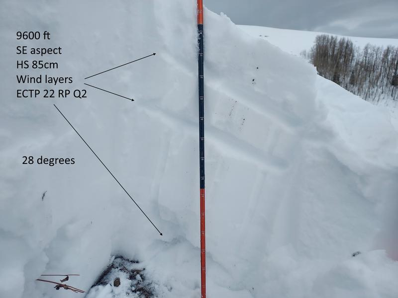
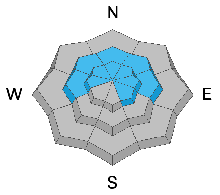
The snowpack in the western Uintas is in a holding pattern. Old, weak snow from November remains capable of fracturing and producing a slab avalanche 1-2 feet deep. While this persistent weak layer is losing its sensitivity, it remains dangerous, and the avalanche danger above treeline where this layer exists is CONSIDERABLE. Slopes near treeline where this layer exists have a MODERATE danger.
The danger is LOW below treeline at low elevations and on all south and southwest-facing slopes.
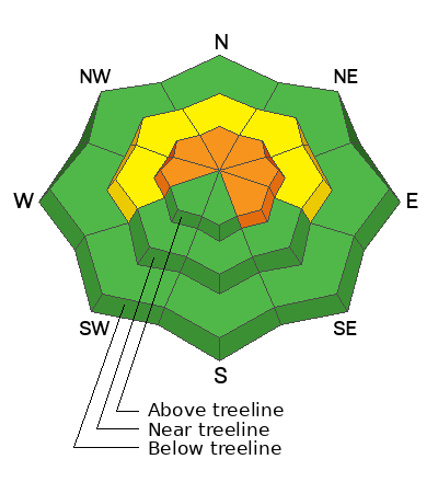
Low
Moderate
Considerable
High
Extreme
Learn how to read the forecast here
Special Announcements
Join the UAC and Young Powersports in Centerville on Thursday, December 14, from 5 - 7 PM for a FREE avalanche transceiver training. Details here.
Weather and Snow
This morning, temperatures are mostly in the mid 20s F, winds are averaging 10-15 mph gusting 20 mph from the WNW, and a few clouds are overhead.
Today, partly cloudy skies will give way to mostly sunny skies, temperatures will warm to near 30 degrees F, and winds will be light blowing from the west.
This week will have quiet weather and lots of sunshine.
Even though it may seem like a slow start to the season, the snowpack is about average (scroll to the bottom of the forecast for more info). There are 3 basic layers in the snowpack (1) old snow from October and mainly November with a crust from mid-November, (2) snow from the warm, wet storm from the first weekend of December with a crust on top of it, and (3) snow from last Friday which favored the northern part of the Uintas.
Total snow depths are generally 20" to 35" and quite supportable on skis, boards, or a sled. Yesterday a regular observer in the Uintas found 2 feet of snow in some places and one north facing area with nearly 4 feet of snow!
(photo: Mike J)
Recent Avalanches
No avalanches have been reported.

Trip reports and the latest observations are found HERE.
Ad
Avalanche Problem #1
Persistent Weak Layer
Type
Location
Likelihood
Size
Description
There is a slab of cohesive snow about 15-20 inches thick that can produce avalanches fracturing on a persistent weak layer of old, faceted snow from November. This situation is here to stay for some time. Several groups on Saturday experienced collapses and audible whumpfs which are clear warning signs. Craig describes the set up in his video from Wolf Creek Pass below:
Additional Information
While it seems like a slow start to the season, in terms of water amounts, SNOTEL sites in the Western Uintas generally have median values. White dots are at the median. Green are a little above, and beige dots are a little below. Click on the image for an interactive map from the NRCS.

We are always looking for snow and avalanche observations or just general riding conditions. So... if you see something, say something. You can reach me directly at [email protected] or 801-231-2170.
Also, if you're looking for more avy education opportunities for yourself, your crew, or your club please don't hesitate to reach out to me and we'll find a presentation, class, or clinic for ya!
General Announcements

Issued at 0700 on Monday, December 11th this forecast will be updated by 0700 Tuesday, December 12th, 2023.
This forecast is from the U.S.D.A. Forest Service, which is solely responsible for its content. This forecast describes general avalanche conditions and local variations always occur.