Forecast for the Uintas Area Mountains

Craig Gordon
Issued by Craig Gordon for
Monday, November 26, 2018
HEADS UP- the storm might be over, but avalanche danger remains sketchy. These are the exact conditions were we see most avalanche accidents and fatalities occur.
At mid and upper elevations, especially on steep wind drifted slopes facing the north half of the compass the avalanche danger is CONSIDERABLE. HUMAN TRIGGERED AVALANCHES ARE LIKELY ON ANY SLOPE HARBORING OLD SNOW NEAR THE GROUND. AND REMEMBER- ANY AVALANCHE BREAKING INTO OLD SNOW WILL HAVE SERIOUS CONSEQUENCES.
Lose the old snow... you lose the problem and the avalanche danger drops dramatically.
Low
Moderate
Considerable
High
Extreme
Learn how to read the forecast here
Special Announcements
We are very proud to introduce our new website for the 2018-19 winter season. This will provide an easier and cleaner way to view all of the snow and avalanche information that you've come to rely on. We are quite happy with how the new website performs on mobile devices as well. We think you'll find the desktop or laptop experience pleasant as well. We are still tying up some loose ends so bear with us.
Weather and Snow
The big holiday storm delivered equal amounts of white goodness across the range, dumping over two feet of much needed snow with about 2" of water. As high pressure gained strength, skies cleared out late Saturday night and remain clear this morning. Currently, temperatures are in the teens and low 20's with northwest winds blowing 10-20 mph along the high ridges. The ridge builds overhead today bringing dry weather, temperatures rising into the mid 30's, and light winds.
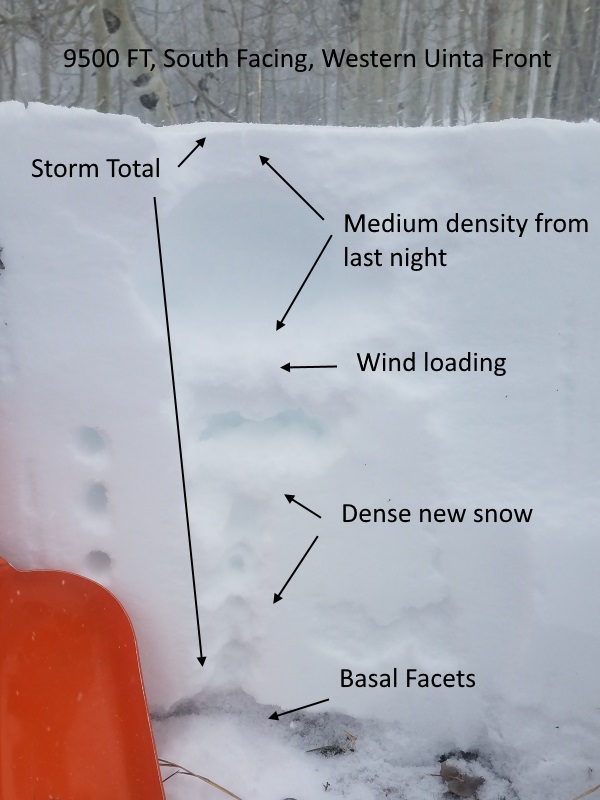
Above is 24 hour data from Trail Lake (9945')
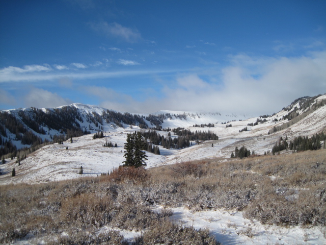
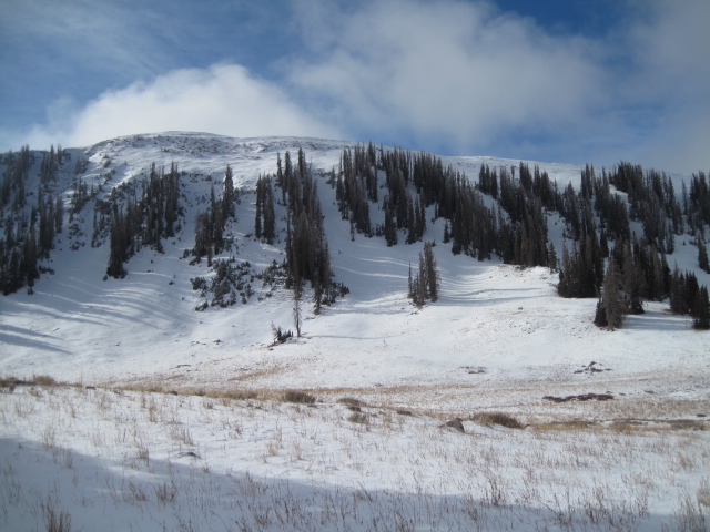
Images above are prior to the big Thanksgiving storm, giving you a sense of the type of terrain where today's avalanche dragon lives. While the storm turned much of our landscape white, riding and turning options are still limited. Low angle, rock free grassy slopes, meadow skipping, or road rides are gonna be your best bet today.
Wanna avoid avalanche danger this today? Of course you do and it's easy. Simply steer clear of any mid or upper elevation slope that has pre-existing, early season snow.
Your exit strategy is to swing around to south facing terrain which has no old snow and you can ride without the worry of avalanches breaking to weak snow near the ground.
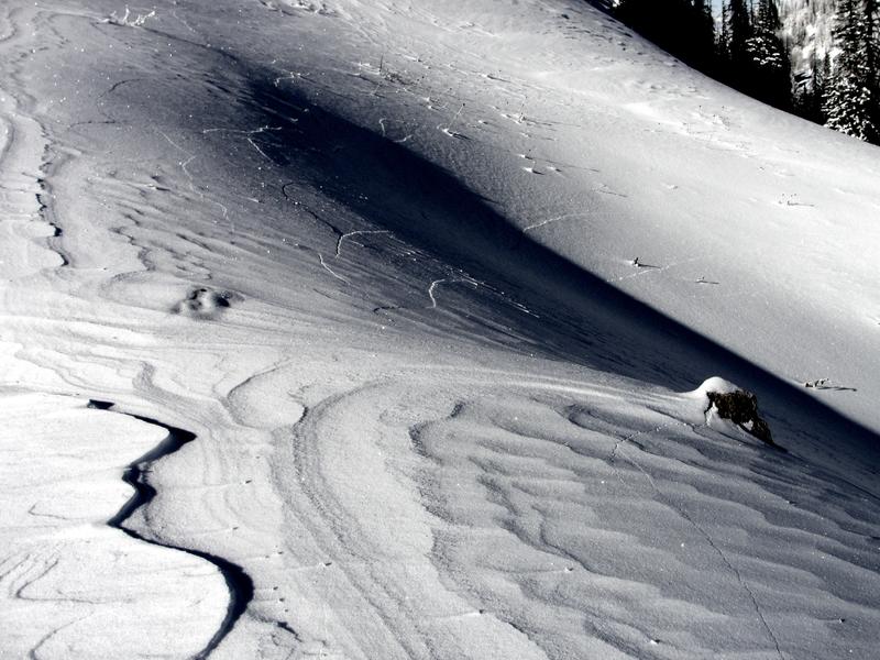
Michael J stomped around the south face of Hoyt Peak on Saturday and found lots of new storm snow resting on warm ground that was bare and brown prior to the thanksgiving storm... now that's the ticket!
Recent Avalanches
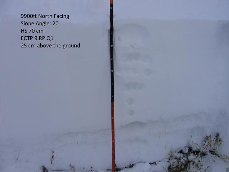
Yesterday, backcountry riders continued to report widespread collapsing, loud booming whoomphs, and shooting cracks like in Michael J's image above... all signs of unstable snow.
Ad
Avalanche Problem #1
Persistent Weak Layer
Type
Location
Likelihood
Size
Description
This was a much needed storm for the range and in most locations we doubled our total snowpack since Thanksgiving Day. So the good news is... we finally have some terrain to ride. The bad news... terrain choices are still very limited and the deepest snow is found on mid and upper elevation slopes facing the north half of the compass. Unfortunately, that's exactly the type of terrain that harbors weak snow near the ground and that's exactly where we could trigger an avalanche that breaks deeper and wider than we might expect. The end result is an unmanageable slide that gets quickly out of hand as it reveals a myriad of hidden obstacles like stumps and rocks that will easily ruin your day or end your season.
Fortunately we have choices and if you want to avoid today's avalanche dragon, you simply avoid mid and upper elevation terrain, particularly shady slopes facing the north half of the compass where the snowpack is weak and sugary.
Plowing is done on Mirror Lake Highway, but Wolf Creek Pass is still open. However, just 'cause you can see your rig parked near Wolf Creek, doesn't mean the terrain you're choosing to ride is good to go.
Remember- this is the time of year where most of us get tricked thinking there isn't enough snow to avalanche. However, this is also the type of setup when most close calls and accidents occur. If you are getting out and about, be prepared for your own self rescue. Wear and know how to use an avalanche beacon, shovel, and probe.
Michael Janulaitis was in the north facing terrain near Hoyt Peak and notes... "my ECT failed after 9 wrist taps on facets above the rain crust about 25 cm above the ground." More on his travels are found here.
Avalanche Problem #2
Wind Drifted Snow
Type
Location
Likelihood
Size
Description
Winds were all over the map during the storm and while I think most have settled out, there might be an old drift or two along the leeward side of an upper elevation ridge or around a terrain feature like a chute or gully that could surprise you. Today you'll want to continue avoiding steep, wind drifted slopes especially if they look fat and rounded or sound hollow like a drum.
Additional Information
Gazing into the weather crystal ball... it looks like a weak storm is on tap for late Tuesday, another storm for late Wednesday, and then a bigger shot for next weekend.
General Announcements
The information in this advisory expires 24 hours after the date and time posted, but will be updated by 7:00 AM Tuesday November 27th, 2018.
If you're getting out and about, please let me know what you're seeing especially if you see or trigger and avalanche. I can be reached at [email protected] or 801-231-2170
It's also a good time to set up one of our very popular avalanche awareness classes. Reach out to me and I'll make it happen.
This information does not apply to developed ski areas or highways where avalanche control is normally done. This advisory is from the U.S.D.A. Forest Service, which is solely responsible for its content. This advisory describes general avalanche conditions and local variations always occur.