March Kicks Off Our Spring Campaign- Donate Now to Support Forecasting

Forecast for the Uintas Area Mountains

Craig Gordon
Issued by Craig Gordon on
Thursday morning, January 9, 2020
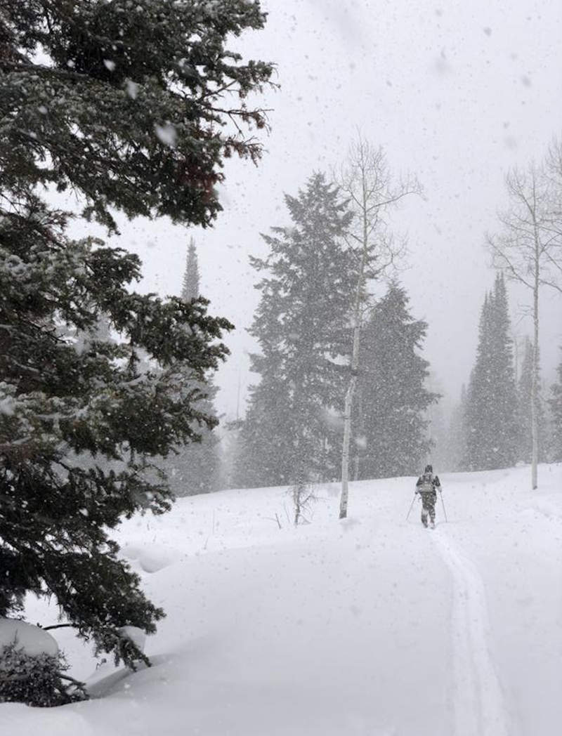
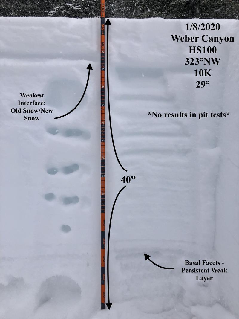
While not widespread and focused on a narrow band of upper elevation terrain in the wind zone, tricky avalanche conditions exist on steep, wind drifted slopes, especially those with an easterly component to its aspect. You'll find a CONSIDERABLE avalanche danger in terrain with these characteristics and human triggered avalanches are PROBABLE. Any avalanche triggered may break to weak snow near the ground, creating a larger avalanche than you might've bargained for.
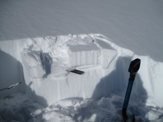
More predictable and manageable in size, you'll find shallow drifts reactive to our additional weight in mid elevation terrain, where a MODERATE avalanche danger exists. Human triggered avalanches are POSSIBLE on steep, wind drifted leeward slopes.
Where to ride?
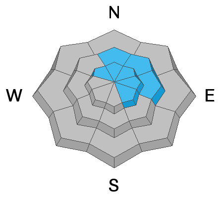
Wind sheltered, low and mid elevation terrain and big open meadows are the place to be where you'll find great riding and generally LOW avalanche danger. In terrain that looks and sound like this, human triggered avalanches are unlikely.
Low
Moderate
Considerable
High
Extreme
Learn how to read the forecast here
Weather and Snow
Currently-
Yesterday's low hanging clouds produced a nice shot of North Slope specific snow with just about 6" of cold light fluff piling up. The south half of the range didn't get the powder party memo and new snow totals are about half that amount. Currently, skies are mostly cloudy, temperatures in the mid teens, and west-southwest winds blow 15-30 mph along the high ridges. There's a lot of wind worked snow in our big open bowls and high alpine terrain, though lose a little elevation, head to wind sheltered slopes and you'll be rewarded with soft, surfy snow. The range has excellent early season coverage with total snow depths averaging close to 4' of settled snow.
Uinta weather network info is found here. Simply click on the Western Uinta tab.
For today-
Occasional snow showers with a couple inches stacking up, though most energy is north of our region. High temperatures climb into the 20's with overnight lows in the single digits. After a lull in the action, the next storm system arrives this evening, ushering in a few hour period of heavier snowfall along with an increase of west-northwest winds bumping into the 40's and 50's late tonight.
Futurecast-
A break for Friday and then the storm track reloads for Saturday into Sunday.
JG's take on the current state of yesterday's storm... "right side up storm snow on a soft, spongy base. Some melt/freeze zipper crust felt underneath new snow from yesterday's warm, sunny day at mid to low elevations." More on his travels found here.
Recent Avalanches
A few shallow wind drifts triggered on steep, leeward slopes is the only avalanche activity to report from yesterday.
To view additional trip reports and recent avalanche activity, simply click here.
Ad
Avalanche Problem #1
Wind Drifted Snow
Type
Location
Likelihood
Size
Description
Look for shooting cracks in the snow like in the image above, which is a sure sign of unstable conditions.
Yesterday's westerly winds were not only obnoxiously cold, they found enough loose snow to whip into a round of fresh wind slabs, that'll react to our additional weight. Most prevalent on upper elevation leeward slopes, there might also be a fresh drift or two cross-loaded onto terrain features like chutes and gullies or even lower down-slope than we usually expect to see. In either case, your best bet for avoidance is to simply steer clear of any fat, rounded piece of snow, especially if it sounds hollow like a drum.
Avalanche Problem #2
Persistent Weak Layer
Type
Location
Likelihood
Size
Description
A tale of two snowpacks-
No new avalanches triggered since Saturday on the south half of the compass where recent avalanche activity revolved around a crust/facet combo. Here's Cody Hughes excellent synopsis... "WE NOW HAVE A PERSISTENT WEAK LAYER ON SOUTH ASPECTS!!! This is a very unusual set up for us and has already caught many off guard with folks taking rides but luckily everyone walking away to ride another day. DON'T LET THIS BE YOU!!! Here is my take on how this setup happened. Beautiful low-density snow over Christmas was kissed gently by the sun on the day of the 26th. That created a thin temperature crust on our solar aspects including the west. Remember weak snow forms above and below crusts... It remained cold the following two days and the snow underneath the crust began to get weak and faceted.
Sage advice from a very experienced key player of our team.
Meanwhile, back on the north half of the compass.... where the pack is deep, it's happy in its own skin. Where the pack is thin snowpit tests indicate a strengthening pack that still has the propensity to avalanche and break on weak snow buried deep in our pack once triggered.
After a rough start and a few speeds bumps along the way, it feels like the snowpack is in a state of equilibrium and happy in its own skin. The good new is... our pack is looking encouragingly solid, especially where it's deep and nearing 4' of total settled snow. The bad news.... no matter how you cut it, we've got persistent weaknesses on all aspects of the compass, particularly in upper elevation terrain. And the bottom line is... anything persistent in our pack is tricky, can take long periods of time to heal, and snowpit stability tests often suggest false "green light" conditions. So that means, you can ride some slopes and be good to go, while others just wait for us to roll along and knock the legs out from underneath. And here's the danger... once initiated, avalanches have a distinct possibility of breaking deeper and wider than you might expect.
Take home-
In either case... we are about to enter a stormy period and it'll test the myriad of snowpack structures, depths, and strength.
Additional Information
Thanks to the generous support of our Utah ski resorts and Ski Utah, we have discount lift tickets available. All proceeds support the UAC. Get your tickets HERE.
Get one of these cool t-shirts to support the UAC and other avalanche centers across the U.S. INFO
General Announcements
The information in this forecast expires in 24 hours, but will be updated by 7:00 AM Friday Jan. 10th.
This forecast is updated daily by 7:00 AM.
In the mean-time, if you see or trigger an avalanche or just wanna let me know what you're seeing you can reach me directly at 801-231-2170
It'll be a minute or two before we're riding, but while you're waiting....
This is a great time of year to schedule one of our free avy awareness presentations.
You can email me directly [email protected]
The information in this forecast is from the US Forest Service which is solely responsible for its content.