Donate to the 2024 Spring Campaign to help rebuild the UAC website.

Forecast for the Uintas Area Mountains

Craig Gordon
Issued by Craig Gordon for
Wednesday, January 25, 2023
Pretty straight-forward these days-
MODERATE avalanche danger is found on steep, upper elevation leeward slopes, especially in the wind zone at and above treeline. Fresh wind drifts reactive to our additional weight are POSSIBLE, particularly on slopes with a south component to their aspect.
Generally LOW avalanche danger is found on all mid and lower elevation slopes.

Low
Moderate
Considerable
High
Extreme
Learn how to read the forecast here
Weather and Snow
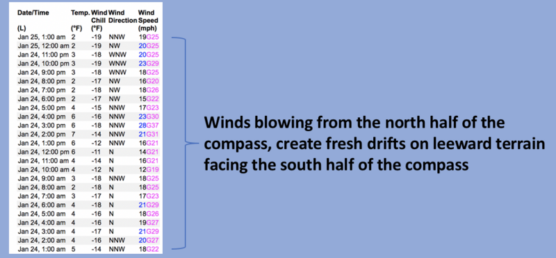
Nowcast- Amazon's weather department over-delivered as it made the rounds through the North Slope late last night, stacking up 6" of low density, cold smoke... a most unexpected sweet, white treat indeed. The south half of the range got skunked and registers just a couple inches of fluff. In either case, we're creeping our way out of the deep freeze with temperatures starting the day in the teens, as northwest winds blow in the mid 20's along the high peaks. Overnight snow does little to soften our big open bowls which are scratchy underfoot. However, don't let your heart be troubled... lose some elevation, seek out wind sheltered terrain, and you'll be rewarded with soft, creamy snow.
Forecast- A few scattered snow showers linger early this morning, but we'll see clearing, with mostly sunny skies on tap by about suppertime. Northwest winds remain well behaved and blow 15-25 mph along the ridges. It'll be crisp, with high temperatures barely reaching into the low 20's while overnight lows crater near zero.
Futurecast- We start to dry out for the latter half of the week with the next best chance for storminess late in the weekend.

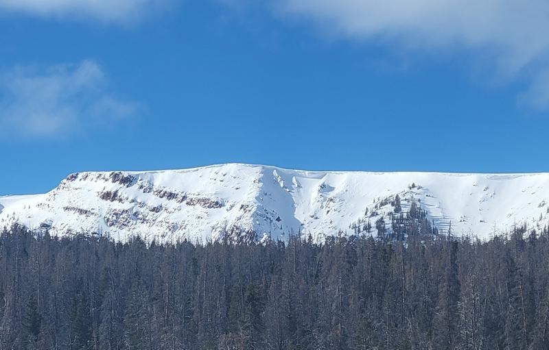
A spectacular image from a recent stomp about on the east side of the range. Click HERE for a great trip report from Henry's Fork.
Huge thanks for all the great obs streaming in from the eastern front. Detailed trip reports and recent obs are found HERE.
Recent Avalanches
No significant recent avalanche activity to report. However, if ya wanna geek out, click HERE to track this years slide activity throughout the range.
Ad
Avalanche Problem #1
Wind Drifted Snow
Type
Location
Likelihood
Size
Description
Windy Peak (10,662') 24 hour data dump shows this remote weather site is not as excited as I am to go to work... slacker. None-the-less, winds blowing from the west, north, and northwest, load a variety of slopes on the south half of the compass.
There's no shortage of snow available to blow around and recent winds have no problem whipping up a fresh round of shallow drifts sensitive to our additional weight. Found on upper elevation leeward slopes, and cross-loaded in chutes and gullies all over the compass, today's drifts might break slightly deeper than you'd expect, but they're manageable by avoidance... lose a little elevation, you lose the wind and you lose the problem.

Additional Information
Colossal water numbers and Herculean snowpack depths are helping the pack turn the corner. This strongly aligns with reasoning to pull the plug on our problem child, the Persistent Weak Layer, which has plagued us since late November... whew!
Weather stations-
And... rime events have severely crippled the Uinta weather station network. I'm working to get it back up and running, but a few stations are found HERE (click weather stations, and then on the Western Uinta tab)
Observations-
Your observations are important, so please let me know what you're seeing... click HERE and contribute to this amazing community-based program
General Announcements
Issued at 03:17 on Wednesday January 25th, this forecast expires 24 hours after the date and time posted, but will be updated by 07:00 Thursday January 26th, 2023.
Before it gets too crazy, now is the time to book an avalanche awareness presentation for your group, club, or posse. You can reach Craig directly at 801-231-2170 or [email protected].

This forecast is from the U.S.D.A. Forest Service, which is solely responsible for its content. This forecast describes general avalanche conditions and local variations always occur.