Forecast for the Uintas Area Mountains

Craig Gordon
Issued by Craig Gordon for
Tuesday, January 2, 2024
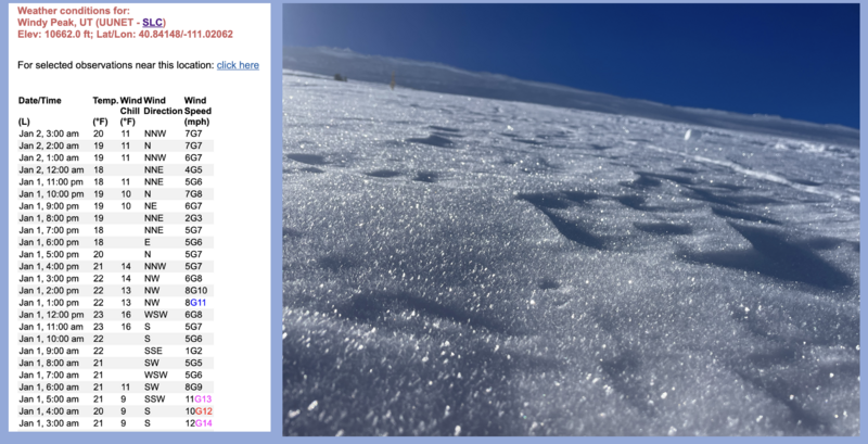
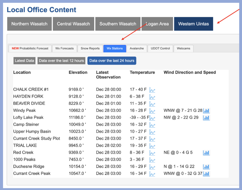
The second day of the New Year offers generally LOW avalanche danger with human triggered avalanches unlikely for the eastern front. For the moment, slamming into a buried treasure like a rock or stump poses a greater hazard.
HEADS UP-
The good news is... the weather pattern appears to change later this week and storminess returns, but that means avalanche conditions change as well. We've got yer back and will keep you updated as the picture becomes more clear.
Low
Moderate
Considerable
High
Extreme
Learn how to read the forecast here
Weather and Snow
Nowcast- High pressure overhead delivers remarkably quiet weather with hardly a puff of wind even near the high peaks. Temperatures are significantly inverted as trailheads wrap up their graveyard shift in the teens, whilst ridgetops continue the New Year revelry in the low 20's. It hasn't snowed in two weeks, but the surface snow is fast and fun, travel is a breeze, and the livin' is easy. Five star shallow pow is the flavor of the day especially on upper elevation terrain facing the north half fo the compass.
Forecast- A good portion of the day is stunning.... expect sunny skies, light winds, and temperatures climbing into the mid 30's. Southerly winds bump into the 20's and 30's tonight ahead of an approaching low pressure system which slides through the region Wednesday afternoon through Thursday.
Furturecast- The Thursday system isn't much to get excited about as the bulk of energy dives south, though we should see a couple traces of snow. A more robust storm still looks on track for Sunday, but details are getting sifted through. The pattern appears cold and active through the second week of January.
This viddy reveals what Joey and I found whilst stomping around in Upper Moffit Basin on Sunday.
Recent Avalanches
Mark captures this facet-slufff-alanche trigered by a skier on the very steep east face of Moffit Peak yesterday, reflecting just how weak the surface snow has grown in the past couple weeks.

Trip reports and the latest observations are found HERE.
Ad
Avalanche Problem #1
Normal Caution
Type
Location
Likelihood
Size
Description
This image illustrates fluctuations in temperature along with hardly a breath of wind along the high ridge formerly known as Windy Peak, driving the creation of the very weak surface snow.
In snow-geek-speak we call this near surface faceting or loud pow. I call it great skiing today, but a sketchy set up if this layer is buried and preserved with storm snow in the upcoming days. With a change in the pattern slated for later in the week, now is the time to get out and about and see the lay of the land for yourself. Whether you record the distribution of this surface weakness on your phone, your camera, or your cerebral hard-drive.... having a clear picture will help you navigate terrain safely once this layer is buried. Remember.... we may forget about these different layers of snow, but the snowpack has an impeccable memory.
Mark posted a great ob from his Moffit Peak travels yesterday and explains the method of the madness HERE.
Additional Information
The Uinta weather station network was upgraded this summer and all that real-time info is found HERE. Simply click on "western Uinta" tab and then "weather stations" tab.

We are always looking for snow and avalanche observations or just general riding conditions. So... if you see something, say something. You can reach me directly at [email protected] or 801-231-2170.
Also, if you're looking for more avy education opportunities for yourself, your crew, or your club please don't hesitate to reach out to me and we'll find a presentation, class, or clinic for ya!
General Announcements

Issued at 0415 on Tuesday, January 2nd this forecast will be updated by 0700 Wednesday, January 3rd, 2024.
This forecast is from the U.S.D.A. Forest Service, which is solely responsible for its content. This forecast describes general avalanche conditions and local variations always occur.