Forecast for the Uintas Area Mountains

Craig Gordon
Issued by Craig Gordon for
Friday, January 19, 2024
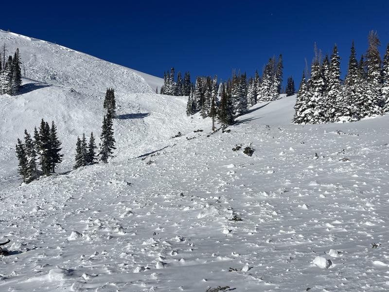
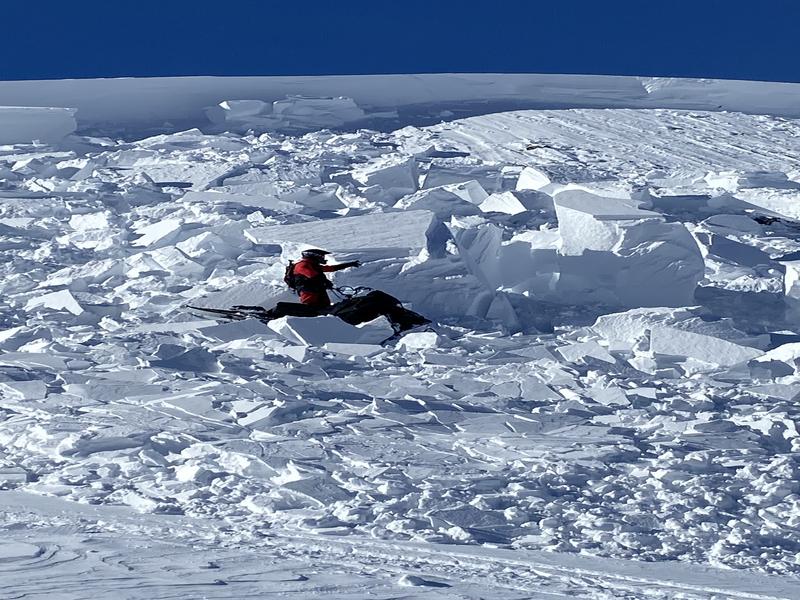
The snow may feel Bomb dot Com under our skis, board, or sled... however, it's far from straight-forward and the jury is still deliberating. What I do know is... guilty until proven othewise. Avalanches are getting harder to trigger, but can break to a persistent weak layer of snow now buried several feet deep in our snowpack, resulting in a catastrophic slide.
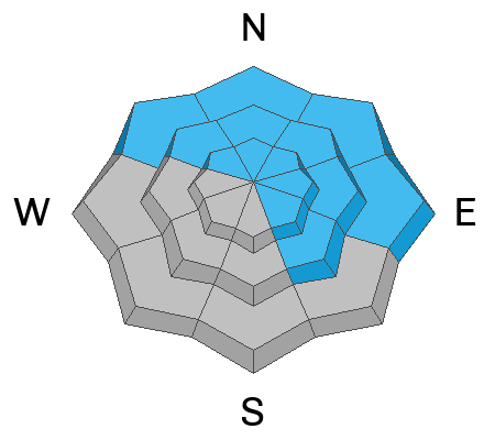
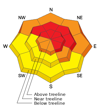
Not as widespread as a few days ago, HIGH avalanche danger still exists on steep, upper elevation slopes and it's particularly sketchy on leeward slopes in the windzone at and above treeline. Human triggered avalanches breaking to deeply buried weak layers are LIKELY in terrain facing the north half of the compass, and especially on slopes with an easterly component to its aspect. Note to self... if I trigger an avalanche it could result in a large and potentially unsurvivable slide.
CONSIDERABLE avalanche danger is found above treeline on the south aspects and below treeline on shady slopes where human triggered avalanches are PROBABLE. In either case, a midpack weak layer remains suspect and is guilty until proven otherwise.
Mid and lower elevation terrain facing the south half of the compass delivers MODERATE avalanche danger and human triggered avalanches are POSSIBLE on steep, wind drifted slopes.

Here's your exit strategy-
We need to continue steering clear of terrain with overhead hazard and that means... avoid being on, under, or connected to steep slopes where we could potentially pull the rug out from underneath and crash the roof down on top ourselves.
Low
Moderate
Considerable
High
Extreme
Learn how to read the forecast here
Weather and Snow
Nowcast- It's a beautiful morning as a band of high clouds drifts to the east with high pressure building over the region. Temperatures remained rather mild overnight, registering in the mid 20's from tip to tail. West winds finally relaxed right after dinnertime last night and currently blow 10-20 mph near the high peaks. On the back end of a week long storm cycle, the eastern front is fat and white with a go-anywhere base, delivering excellent riding and turning conditions.
Forecast- It'll be a glorious day in the mountains with sunny skies, light winds, and high temperatures climbing into the mid 30's. Overnight lows dip into the 20's. Southwest winds gradually increase tonight as high pressure slides off to the east and the next storm system begins making its way to the Beehive State.
Futurecast- Saturday is a transition day with increasing clouds and wind and a round of storminess. I'm thinking 3"-5" of snow by Sunday morning. A break on Monday and another weak and mild storm for midweek. These are warm storms delivering higher density snow.

Snow summary from NRCS SNOTEL sites:
Chalk Creek #1 (9,171') - 53" snow depth (10.6" total water)
Trial Lake (9,992') - 65" snow depth (10.3" total water)
Wolf Creek Peak (9,796') - 44" snow depth (8.3" total water)
Currant Creek (7,915') - 33" snow depth (7.7" total water)
Daniels-Strawberry (8,008') - 41" snow depth (8.5" total water)
Strawberry Divide (8,123') - 50" snow depth (11.2" total water)
Recent Avalanches
No reported avalanche activity yesterday, but below are a few highlights from earlier this week-
Packing heat! An impressive debris pile stacked up as a result of a large, natural avalanche on the North side of Double Hill which avy-savvy, snow-pro's Ted Scroggin and Steve Martin documented HERE along with a great viddy captured HERE.
And earlier in the week on the south half of the range this slide triggered mid slope on a heavily wind loaded east facing slope at 9,500' in Blind Stream has similar characteristics.

Read more Uinta observations and avalanches HERE.
Ad
Avalanche Problem #1
Persistent Weak Layer
Type
Location
Likelihood
Size
Description
Mark describes in excellent detail, what he and Westin D found whilst visiting the Iron Mine area Tuesday.
Here's the setup-
A dense, cohesive slab rests on top of weak, sugary snow developed during the mid December dry spell... strong snow on weak snow. It's a dangerous combo because the snow feels solid underneath us, suggesting we're good to go. In fact, we'll be able to get well out onto a slope before we kick the legs out from underneath and trigger a slide that breaks much deeper and wider than we might've bargained for. And once triggered, we're gonna be staring down the barrel of a very dangerous avalanche. The key to longevity is in our hands... we just need to recognize we're slowly trending in the right direction, but the snowpack still needs some time to adjust to last weeks big storm. There's plenty of lower angle terrain out there where we can have a blast. So, let's keep it tight and not pull the avalanche dragons tail today... guaranteed its bite is worse than its bark!
Avalanche Problem #2
Wind Drifted Snow
Type
Location
Likelihood
Size
Description
Above is a 24 hour data dump from Windy Peak (10,661')
Recent and older wind drifts-
Winds were all over the map as last weeks storm began to materialize and we've identified drifting in some unusual locations. While they're beginning to settle and become a bit more stubborn, I bet you can still find a wind drift or two reactive to our additional weight. Found mostly on the leeward side of mid and upper elevation ridges, I suspect you'll also find shallow drifts at lower elevations and around terrain features like chutes and gullies. In addition, there may be a few older drifts that formed late last week as the storm cycle got going. Older drifts are harder to trigger, but once initiated they'll be packing a punch.
In either case, the ticket is to avoid fat rounded pillows of snow, especially if they sound hollow like a drum.
Additional Information
The Uinta weather station network was upgraded this summer and all that real-time info is found HERE. Simply click on "western Uinta" tab and then "weather stations" tab.

We are always looking for snow and avalanche observations or just general riding conditions. So... if you see something, say something. You can reach me directly at [email protected] or 801-231-2170.
Also, if you're looking for more avy education opportunities for yourself, your crew, or your club please don't hesitate to reach out to me and we'll find a presentation, class, or clinic for ya!
General Announcements

Issued at 0400 on Friday, January 19th this forecast will be updated by 0700 Saturday, January 20th, 2024.
This forecast is from the U.S.D.A. Forest Service, which is solely responsible for its content. This forecast describes general avalanche conditions and local variations always occur.