Forecast for the Uintas Area Mountains

Craig Gordon
Issued by Craig Gordon on
Sunday morning, January 17, 2021
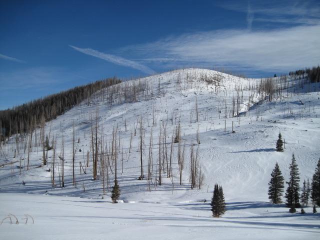
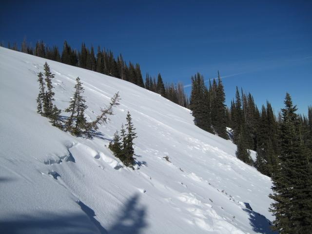
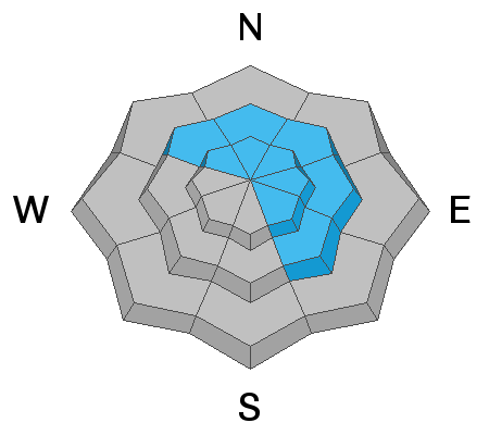
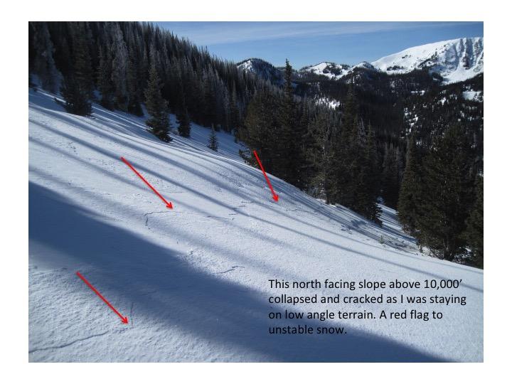
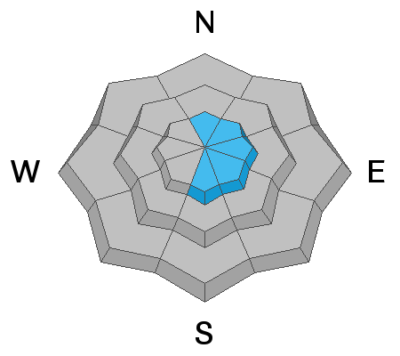
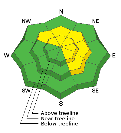
Today you'll find MODERATE avalanche danger near and above treeline on slopes facing northwest through southeast. Ironically, these slopes have the best coverage and the most snow. Human triggered avalanches are POSSIBLE, especially on slopes loaded by recent winds. Any slide triggered may break into old, weak, faceted snow, creating a larger avalanche than you might expect.
All other slopes at low elevations and those facing west and south offer minimal snow and generally LOW avalanche danger.
The best places to ride are shaded slopes near treeline with the deepest snow. But you'll need to put some thought into it... avoid slopes with fresh drifts and terrain steeper than 30 degrees and you'll avoid avalanches.
Low
Moderate
Considerable
High
Extreme
Learn how to read the forecast here
Special Announcements
Discount lift tickets are available thanks to the generous support of our local resorts, Ski Utah, and Backcountry. Support the UAC while you ski at the resorts this season. Tickets are available here.
Weather and Snow
Nowcast-
Skies are clear, stars are popping, and temperatures register in the low 20's... yes, it's a spectacular morning! Northwest winds bumped into the 20's and 30's right around dinner time last night and continue in the same spirit as I type this forecast at 03:30. Yesterday's storm delivered a shallow coat of white paint with just an inch or two across the range and total settled snow depths register in the two-three foot range.
Forecast-
High pressure brings sunny skies with temperatures climbing into the mid 30's and overnight lows dipping into the teens. Northwest winds continue blowing in the 30's and 40's, decreasing late in the day.
Futurecast-
Another weak storm slides into the region overnight with just an inch or so expected. Maybe a glimmer of hope for more storminess by next weekend.

Overall snow depths are 2-3 feet with many slopes above treeline affected by recent winds. More sheltered slopes have recrystallized powder on the surface and a soft crust on southerly facing slopes. Ted Scroggin put it best saying "The coverage out in Mill Creek is ok, but there are many logs and stumps to watch out for. It is white, but white and lumpy." The photo below from Ted shows snow coverage in that area.

Looking for real-time temps, snow, or wind?
Click here and then on the "western Uinta" tab for western Uinta specific, weather station network.
Recent Avalanches
The moose is loose and Ted found 'em triggering pockety slabs near Gold Hill.
On Thursday, there was a natural avalanche reported on Tower Mountain involving wind drifted snow.
Read other trip reports here.
Ad
Avalanche Problem #1
Persistent Weak Layer
Type
Location
Likelihood
Size
Description
The most likely places to trigger an avalanche are on slopes facing the north half of the compass, particularly east facing slopes, loaded by recent winds. In terrain with these characteristics, avalanches may break 1-2 feet deep, failing on a persistent weak layer of facets generally found about a foot above the ground.
On Friday, Mark and I rode out of Mill Hollow and we found two things: (1) The snowpack is generally weak, rotten, and full of facets. Even the snow surface has faceted which made for great skiing conditions. (2) Strong, west and northwest winds blew on Wednesday and Thursday and again overnight. Further north just east of Bear River in Mill Creek, Ted Scroggin found similar conditions and has a great report here.
What does all of this mean? Below treeline, the snowpack is basically one big persistent weak layer lacking a slab on top to create an avalanche. Near treeline snow depths increase some, and there is more of a slab on top of the weak snow. Without loading from significant snowfall, weak facets buried in the snowpack aren't as sensitive as they were last weekend except in places loaded by recent winds.
Photo - north aspect near 10k feet. Snow layers near the shovel blade is snow that fell in November and early December. The weakest snow is the obvious stripe of facets near the top edge of the shovel blade. That stripe of weak snow sits on a decomposing crust. Snow near the shovel handle is the slab that can create an avalanche. Slopes with the added weight of wind drifted snow on top of this layering are the ones most likely to avalanche.
Ted says.... "It felt like the theme of the day was cracking and collapsing of the weak snow pack and some of the collapses were quite attention getting. I was not anticipating too many red flags today, but the Gold Hill zone felt fairly unstable and a little on the "spooky" moderate side of the danger scale." Some sage advice from a super knowledgeable avy, savvy pro who knows the Uinta's better than all of us.... combined!
Avalanche Problem #2
Wind Drifted Snow
Type
Location
Likelihood
Size
Description
Very strong winds blew from the west and northwest on Wednesday and Thursday and ramped up again overnight. Both, new and old wind slabs formed on leeward slopes adding weight and stress to a persistent weak layer of facets as described above. Today you'll want to look for and avoid fat, rounded pieces of snow, especially if they sound or feel hollow like a drum.

There are two types of wind loading patterns to look for - top loading and cross loading as shown in the two images below.
Additional Information
I will update this forecast by 7:00 AM tomorrow, Monday January 18th.
Your observations are import, so please let me know what you're seeing... click HERE and contribute to this amazing community based program
General Announcements
If you see or trigger an avalanche or just wanna let me know what you're seeing you can reach me directly at 801-231-2170 or [email protected]
This forecast is from the U.S.D.A. Forest Service, which is solely responsible for its content. This forecast describes general avalanche conditions and local variations always occur.