Forecast for the Uintas Area Mountains

Craig Gordon
Issued by Craig Gordon for
Sunday, January 13, 2019
In the wind zone, at and above treeline the avalanche danger is MODERATE. Human triggered avalanches are POSSIBLE on steep slopes with recent deposits of wind drifted snow, particularly those facing the north half of the compass, and especially those an easterly component to their aspect
Any avalanche that breaks into deeper buried weak layers near the ground will result in a deep, scary, and dangerous avalanche.
While less widespread and pockety in distribution, a MODERATE avalanche danger is also found on steep, wind drifted slopes at mid elevations.
If you're looking for LOW avalanche danger, simply head to lower elevation terrain or big open meadows with no steep terrain above or connected to where you're traveling.
Low
Moderate
Considerable
High
Extreme
Learn how to read the forecast here
Special Announcements
Big thanks to Mike Poulsen and the great crew at Tri-City Performance along with the Park City Powder Cats for hosting this weeks Avy Moto 101
Stay tuned for more details regarding our next Sled Avy 101 in February.
Weather and Snow
Above the gunk, funk, and valley junk you'll find clear, clean air and temperatures in the teens. East and northeast winds bumped slightly into the 20's and 30's for a few hours last night, but have relaxed somewhat and currently blow less than 20 mph along the high peaks. Riding and turning conditions are straight-forward... low elevation terrain and sunny aspects took on heat the past few days and are crusted, but there's still plenty of cold, shallow snow on wind sheltered, shady slopes.
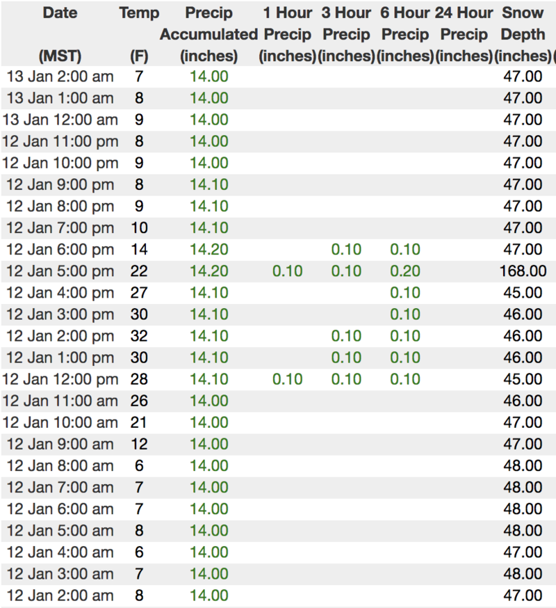
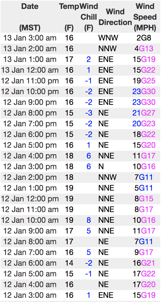
Above is hourly data from Trial Lake (9,945') along with recent wind data from Windy Peak (10,662'). To view more regional weather stations click here.
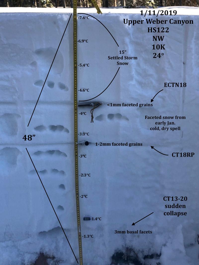
A beautifully detailed pit submitted by JG who was in Weber Canyon yesterday, reveals some bad juju near our faceted layers of snow. More on his travels here.
Recent Avalanches
The pocket above was triggered yesterday on a steep, upper elevation north facing slope in Humpy Basin. While only 50' wide, it broke 4' deep, running 350' vertically and failed on weak snow near the ground. The sketchy thing is... this slide was triggered remotely from low on the slope.
On Friday, a very experienced avy forecasting team remotely triggered the avalanche in the image above while descending a lower angle, adjacent slope. Breaking 2'-4' deep and 400' wide, this slide was initiated from a distance, on an upper elevation southeast facing slope, broke to weak snow near the ground, and stacked up a tremendous amount of debris in the gully of the runout.
Now here's the curious as well as the spooky thing about this incident.... this is the 6th notable slide triggered on a southeast aspect which is quite unusual given the fact that we generally steer towards the sunny terrain when we're dealing with persistent weaknesses in the snowpack. However, a common theme we're seeing is this... nearly every big slide triggered since the New Years snow and wind event has had an easterly component to its aspect.
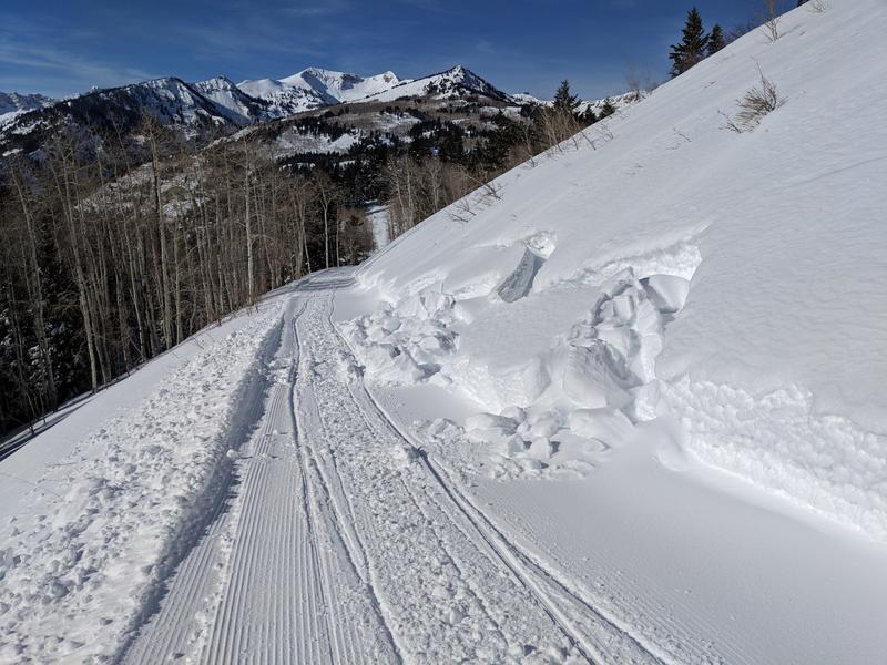
There's been no shortage of human triggered slides the past few days including a couple close calls, but fortunately everyone has come out on top. Please... let's keep it that way.
Ad
Avalanche Problem #1
Persistent Weak Layer
Type
Location
Likelihood
Size
Description
You'd think by now our persistent weak layer issues would be done... and in much of our terrain it is. And while it's been a week since the snowpack received a big thump of water, snow, and wind, it was exactly that combo that brought dormant, persistent weak layers back to life, particularly in terrain where the snowpack is thin and weak. Now here's the problem- "persistent weak layers" in the snowpack are a headache because all we need to do is find one weakness, maybe around a bush or rock that we can't see buried underneath the snow, collapse the pack, and now we've triggered a deep, dangerous avalanche. Another wild card to add to the deck is the possibility of triggering an avalanche low on the slope or from an adjacent slope.
So you're asking, "how do we manage an unmanageable avalanche dragon is the snowpack?" Well we simply avoid it and the usual suspects come to mind- steep, rocky terrain and slopes that have already avalanched this year. In addition, periphery terrain where the pack has remained shallow all season should be considered guilty until proven otherwise.
Chad was in a weak snow zone yesterday. His viddy clearly shows the setup.
Avalanche Problem #2
Wind Drifted Snow
Type
Location
Likelihood
Size
Description
A bump in the winds overnight may have found enough loose snow to blow around and form a fresh drift or two along the leeward side of upper elevation ridges, but I don't these these are gonna be particularly widespread. However, the Uintas are a big place, so look for and avoid any fat, rounded piece of snow especially if it sounds hollow like a drum.
You can get a good handle on the avy hazard close to the trailhead and make solid riding decisions based on your observations. Shooting cracks and small avalanches on road cuts like pictured in the image above, is a huge red flag and great indicator of unstable snow.
Additional Information
High pressure over the region, brings clear skies, temperatures rising into the 30's, along with light northerly winds. Quiet weather is on tap through the weekend and then a few weak impulses slide through the region beginning mid week. Nothing big on tap, but likely enough new snow over the course of a few days for a shallow reset. Perhaps a colder, wetter system to round out the end of work week.
General Announcements
The information in this advisory expires 24 hours after the date and time posted, but will be updated by 7:00 AM Monday January 14th, 2019.
If you're getting out and about, please let me know what you're seeing especially if you see or trigger and avalanche. I can be reached at [email protected] or 801-231-2170
It's also a good time to set up one of our very popular avalanche awareness classes. Reach out to me and I'll make it happen.
This information does not apply to developed ski areas or highways where avalanche control is normally done. This advisory is from the U.S.D.A. Forest Service, which is solely responsible for its content. This advisory describes general avalanche conditions and local variations always occur.