March Kicks Off Our Spring Campaign- Donate Now to Support Forecasting

Forecast for the Uintas Area Mountains

Craig Gordon
Issued by Craig Gordon on
Sunday morning, January 12, 2020
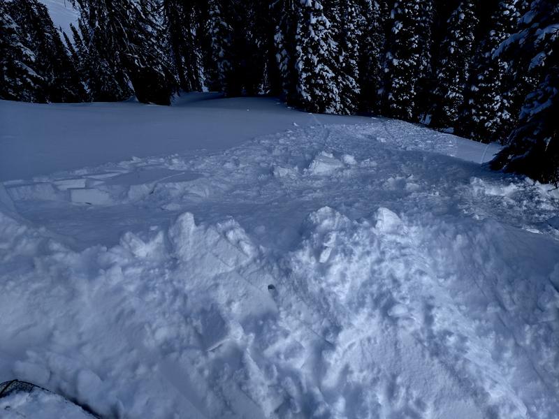
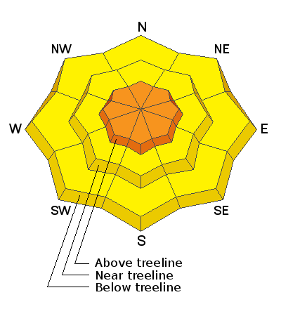
In upper elevation terrain in the wind zone, tricky avalanche conditions exist on steep, wind drifted slopes, especially those with an easterly component to its aspect. You'll find a CONSIDERABLE avalanche danger in terrain with these characteristics and human triggered avalanches are PROBABLE. Any avalanche triggered may break to weak snow near the ground, creating a larger avalanche than you might've bargained for.
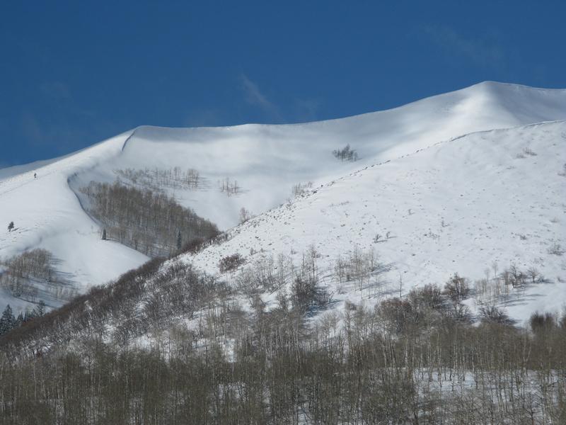
More predictable and manageable in size, you'll find shallow drifts reactive to our additional weight in mid elevation terrain, where a MODERATE avalanche danger exists. Human triggered avalanches are POSSIBLE on steep, wind drifted leeward slopes.
Just the shear amount of new snow warrants a heads up on steep, lower elevation terrain where a MODERATE avalanche danger is found and human triggered slides and sluffs are possible.
Low
Moderate
Considerable
High
Extreme
Learn how to read the forecast here
Weather and Snow
Currently-
The time stamp on yesterday's storm was slightly skewed, the package arrived later than expected, but intensified overnight, and man... it is stomping snow as I type this mornings update. It's a North Slope kinda storm with a solid 12" of light density snow stacking up in the past 24 hours. Storm totals are about half that amount from Trail Lake southward. West and southwest winds relaxed late last night, but just starting bumping into the 20's and 30's along the high ridges. Current temperatures register in the single digits and low teens. Riding and turning conditions are all-time and it'll be over-the-hood and over-the-head. The range has excellent early season coverage with total snow depths averaging just over 4' of settled snow.
Uinta weather network info is found here. Simply click on the Western Uinta tab.
For today-
Heavy snow continues for the next few hours, before turning showery and tapering off. High temperatures reach into the teens with overnight lows in the single digits. West and southwest winds bump into the 30's and 40's along the high peaks. We should see a break in the action before another system slides through the region tonight into Monday.
Futurecast-
More storms jump on the snow train for the upcoming week. Expect yet another system for Monday/Tuesday, a break for Wednesday/Thursday, with another storm slated for late Thursday/Friday.
Recent Avalanches
Yesterday, Micheal J found the new snow sensitive and was able to initiate shallow wind drifts and long running sluffs on sustained steep slopes. Otherwise, no significant avalanche activity report. More on Micheal's travels found here.
To view additional trip reports and recent avalanche activity, simply click here.
Ad
Avalanche Problem #1
Wind Drifted Snow
Type
Location
Likelihood
Size
Description
Easy to observe from a distance as you make your trip plan... winds have been blowing from the left (windward) and loading slopes on the right (leeward)
Winds ramped up early this morning and they'll have no shortage of fresh snow to work with. I expect very tender, fresh drifts will easily react to our additional weight. Most prevalent on upper elevation leeward slopes, there might also be a fresh drift or two cross-loaded onto terrain features like chutes and gullies. In either case, your best bet for avoidance is to simply steer clear of any fat, rounded piece of snow, especially if it sounds hollow like a drum. Once triggered, today's fresh drifts may break a bit deeper and wider than you might expect.
Avalanche Problem #2
Persistent Weak Layer
Type
Location
Likelihood
Size
Description
Above, a short viddy illustrating a snow stability test at the crown of a recently triggered slide. Thanks Jason Boyer for sharing this critical information.
This weeks storm snow and water are starting to stack up. And while the snowpack isn't teetering on the edge, this additional weight and stress may begin to wake up some of our persistent weak layers buried in the mid portion of our snowpack. The good news is... our pack is looking encouragingly solid, especially where it's deep and nearing 4' of total settled snow. The bad news.... no matter how you cut it, we've got persistent weaknesses on all aspects of the compass, particularly in upper elevation terrain. And the bottom line is... anything persistent in our pack is tricky, can take long periods of time to heal, and snowpit stability tests often suggest false "green light" conditions. So that means, you can ride some slopes and be good to go, while others just wait for us to roll along and knock the legs out from underneath. And here's the danger... once initiated, avalanches have a distinct possibility of breaking deeper and wider than you might expect.
Take home-
Let's keep our eyes on the prize.
We're in a stormy pattern and additional weight will test the myriad of snowpack structures, depths, and strength.
Avalanche Problem #3
New Snow
Type
Location
Likelihood
Size
Description
We've had a lot of new snow this week and now its stacking up around our trailheads and at lower elevations. Remember... even if you're headed out for a trail run, snowshoe, dog walk, or family sled adventure, be aware of steep slopes above and adjacent to where you're playing and avoid terrain traps like gullies and streambeds.
Additional Information
Thanks to the generous support of our Utah ski resorts and Ski Utah, we have discount lift tickets available. All proceeds support the UAC. Get your tickets HERE.
Get one of these cool t-shirts to support the UAC and other avalanche centers across the U.S. INFO
General Announcements
The information in this forecast expires in 24 hours, but will be updated by 7:00 AM Monday Jan. 13th.
This forecast is updated daily by 7:00 AM.
In the mean-time, if you see or trigger an avalanche or just wanna let me know what you're seeing you can reach me directly at 801-231-2170
It'll be a minute or two before we're riding, but while you're waiting....
This is a great time of year to schedule one of our free avy awareness presentations.
You can email me directly [email protected]
The information in this forecast is from the US Forest Service which is solely responsible for its content.