Donate to Our Spring Campaign or Bid on our Spring Auction to Support Forecasting

Forecast for the Skyline Area Mountains

Brett Kobernik
Issued by Brett Kobernik on
Tuesday morning, March 25, 2025
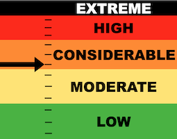
The majority of the terrain on the Manti Skyline has a LOW to MODERATE danger rating and human triggered avalanches are not very likely.
A CONSIDERABLE avalanche danger still exists in very steep upper elevation terrain that faces north, northeast and east where there is still a slim chance that a person could trigger a deep and dangerous avalanche.
Avoidance is key as there is no sure way to determine which slopes are stable and which are not.
Low
Moderate
Considerable
High
Extreme
Learn how to read the forecast here
Weather and Snow
Current Conditions: The warm weather on Monday pretty much cooked the rest of the good riding snow. Even high north facing terrain became damp. Temperatures were into the 40s and cooled down to around freezing overnight. Wind is almost calm.
Mountain Weather: We're basically going to have mostly sunny skies with high temperatures into the 50s over the next three days. Wind will be generally light. There is an odd chance for minor precipitation (most likely light rain) late Wednesday. This looks like a very minor disturbance if it even materializes. Things cloud up Friday with slightly cooler temperatures then a small storm moves through our area Saturday that might bring a few inches of snow. The weather looks quiet for the first 10 days of April.
Ad
Avalanche Problem #1
Persistent Weak Layer
Type
Location
Likelihood
Size
Description
There is still a small chance of triggering a deep and dangerous avalanche today. Unfortunately, the most likely places to do this are the exact places we often find ourselves at this time of the season: upper elevation north through east facing steep terrain.
The majority of the slopes will stay in place. Some will release if provoked. You will not see any signs of danger. The snowpack will feel stable and "bomber". There is no way to tell which slopes will stay in place and which ones might release if you get onto them. All you can do is avoid that terrain. Or roll the dice.
Avalanche Problem #2
Wet Snow
Type
Location
Likelihood
Size
Description
The second thing to consider is wet snow activity. This generally does not pose much threat to people on the Skyline but here's what to consider:
  • When the snow gets REALLY wet and saturated, it can become unstable and start producing natural avalanches on very steep slopes.
  • People can also initiate avalanches when the snow gets really sloppy.
  • Simply avoid being on or below steep slopes later on in the day when the snow gets sloppy wet.
One main reason this isn't a huge threat to people is that often, travel conditions on skis, snowmobiles, and snowshoes are terrible when the snow gets that wet and sloppy and people usually aren't in avalanche terrain then anyway.
General Announcements
This forecast is from the U.S.D.A. Forest Service, which is solely responsible for its content. This forecast describes general avalanche conditions and local variations always occur.