31st Annual Backcountry Benefit - September 12th - Tickets Available Here!

Forecast for the Skyline Area Mountains

Brett Kobernik
Issued by Brett Kobernik on
Wednesday morning, February 7, 2024
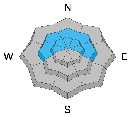
I've bumped the overall avalanche danger up to the CONSIDERABLE danger rating.
Anticipate human triggered avalanches involving the newer layers of snow. These could be up to a foot deep.
There is still a chance that a person could trigger a deeper more dangerous avalanche that breaks into weak snow near the ground. Additional snow today and through the rest of the week will enhance the chances for these avalanches.
Low
Moderate
Considerable
High
Extreme
Learn how to read the forecast here
Weather and Snow
Current Conditions: 4 to 6 inches of snow overnight with stations on the east side of the Skyline picking up the most. Temperatures have been in the mid 20s. Wind from the south southeast was slightly breezy Tuesday and has now slowed. Riding conditions should be pretty decent today.
Mountain Weather: Today's portion of this messy series of storms is looking more impressive to me. The flow will trend more from the southwest and west with generally light to moderate wind speeds. It could get a little stronger late this afternoon. Temperatures should stay in the mid 20s or cool slightly. We should see periods of snow through most of today and tonight. I think we could see 6 to 10 inches of new snow by sometime Thursday morning. There will be more periods of snow Thursday and Friday then things start to clear out Saturday.
Ad
Avalanche Problem #1
New Snow
Type
Location
Likelihood
Size
Description
As the new snow stacks up today, this will be the period when it is most sensitive. I'm unsure of just how sensitive these upper layers of new snow will be. Watch for cracking within the snow surface indicating sensitive conditions. Use small test slopes to get an idea of the sensitivity. Areas where the wind has drifted snow will be the most likely places to trigger a new snow avalanche.
Avalanche Problem #2
Persistent Weak Layer
Type
Location
Likelihood
Size
Description
I'm still very concerned about the weak sugary snow near the ground. The concern is a person triggering an avalanche that breaks deep into the Persistent Weak Layer from December. I have a lot of uncertainty about how likely that is. As we add more snow this week, a pattern should reveal itself. I could see things going two ways. First, the additional snow doesn't stress the old weak layers enough to cause problems. On the other hand, the weight of the new snow may be enough to wake up the dragon. Here's how I'm handling this situation. Since there are uncertainties, I continue to avoid the steep slopes until I see solid evidence of a more stable snowpack.
General Announcements
This forecast is from the U.S.D.A. Forest Service, which is solely responsible for its content. This forecast describes general avalanche conditions and local variations always occur.