Check out our Holiday Auction - Sign Up for the Utah Snow and Avalanche Workshop (USAW)

Forecast for the Skyline Area Mountains

Brett Kobernik
Issued by Brett Kobernik on
Monday morning, February 12, 2024
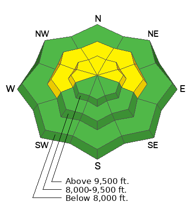
The overall danger rating on the Skyline is rated MODERATE.
Human triggered avalanches are possible but not all that likely today.
There is a small chance that a person could trigger a deep and dangerous avalanche. The most likely places are on very steep slopes that face west, north and east in the mid and upper elevations where the snowpack is thinner and shallow.
Low
Moderate
Considerable
High
Extreme
Learn how to read the forecast here
Weather and Snow
Current Conditions: It was another glorious day in the mountains on Sunday with continued excellent riding conditions. The sun heated up southerly facing slopes so you'll find a crust there this morning. Temperatures are around 20˚F and the wind has shifted and is more from the west but still pretty light in speed.
Mountain Weather: Today looks like there will be a lot of sun again with high temperatures into the upper 20s. Wind should remain light to moderate in speed from the west. We'll see a few more clouds moving in through the end of the week. There's really no significant chance for snow for about a week.
Recent Avalanches
There were no avalanches reported from the Skyline on Sunday. However, there was one large snowmobile triggered avalanche in the Western Uintas. This avalanche broke deep into weak snow near the ground. The reason I think this is pertinent is that the Skyline has a pretty similar snowpack to the Uintas.
Ad
Avalanche Problem #1
Persistent Weak Layer
Type
Location
Likelihood
Size
Description
You will still want to keep in mind that a deep dangerous avalanche could be triggered today. The chances of triggering one are slim but the consequences could be lethal.
The deeper areas like around the Fairview zone hold a more stable snowpack and the chances for triggering an avalanche are less.
The snowpack is a bit shallower south of Horseshoe Mountain and this terrain is where it is more likely to trigger something.
Overall, we are moving in a good direction with the avalanche danger decreasing and the snowpack becoming more stable.
General Announcements
This forecast is from the U.S.D.A. Forest Service, which is solely responsible for its content. This forecast describes general avalanche conditions and local variations always occur.