Forecast for the Skyline Area Mountains

Brett Kobernik
Issued by Brett Kobernik for
Monday, December 20, 2021
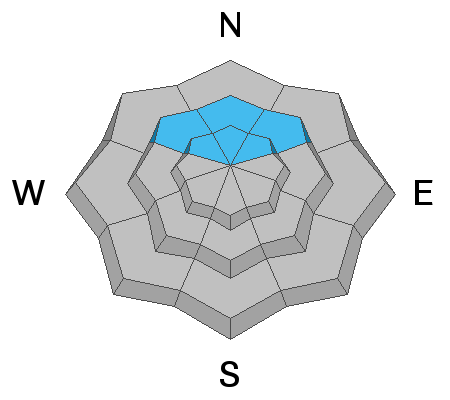
A CONSIDERABLE avalanche danger exists on slopes of 35 degrees or steeper on northwest, north and northeast facing slopes above about 9000'. Outside of that terrain, the danger is LOW.
Collapsing or "whoomping" of the snowpack along with shooting cracks are two big signs of unstable snow. If you are traveling in high elevation northerly facing terrain, keep your slope angles to 30 degrees or less to stay safe.
Low
Moderate
Considerable
High
Extreme
Learn how to read the forecast here
Weather and Snow
Current Conditions
Without much wind, riding conditions were still good on Sunday although we only have about 2 feet of total snow depth across the higher terrain on the Skyline. Temperatures have remained mild over the last 24 hours staying in the mid 20s.
Mountain Weather
We have three more days of mild weather with clouds finally moving in on Wednesday. A series of storms are shaping up and it looks like we'll start to see some new snow on Thursday. The pattern is active over the next couple of weeks so we should see some decent accumulations.
Ad
Avalanche Problem #1
Persistent Weak Layer
Type
Location
Likelihood
Size
Description
A buried persistent weak layer of sugary faceted snow is our biggest concern. This will continue to be our focus during the next storms. On Sunday my partner and I again experienced countless large collapses (whoomping) of the snowpack. We descended a northeast facing bowl and the entire thing collapsed and shattered like a pane of glass. Had the slope been steeper, it would have avalanched. That said, if the slope was steeper, we wouldn't have been on it in the first place. Sticking to slopes of 30 degrees in steepness or less is the only way to stay safe in the higher elevation northerly facing terrain right now.