Forecast for the Skyline Area Mountains

Brett Kobernik
Issued by Brett Kobernik for
Saturday, December 1, 2018
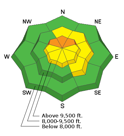
There is a CONSIDERABLE avalanche danger on the steep slopes facing northwest, north and northeast above 9500' in elevation. HUMAN TRIGGERED AVALANCHES ARE LIKELY. Expect human triggered avalanches in this terrain because of old weak snow near the ground. Outside of the described terrain where there was no old snow, the avalanche danger is generally LOW to MODERATE. Watch for any cracking in freshly wind drifted snow.
Low
Moderate
Considerable
High
Extreme
Learn how to read the forecast here
Weather and Snow
The Skyline received another 10 inches of snow in the last 24 hours bringing storm totals up to about 2 feet containing around 2.3" of water. Snow densities have been decreasing. The wind increased a bit more and was from the northwest with gusts to 40 mph along the highest peaks. Temperatures have been dropping and are in the low to mid teens.
There are a handful of backcountry observations with more detail about this season's snowpack: CLICK HERE
We'll have a break in the storms today with partly to mostly cloudy skies, high temperatures into the mid 20s and light to moderate speed west wind. Another system will move through tonight and Sunday bringing perhaps 2 to 4" of snow. The long term pattern continues to look active with some minor disturbances during the week and a better looking storm toward next weekend.
Ad
Avalanche Problem #1
Persistent Weak Layer
Type
Location
Likelihood
Size
Description
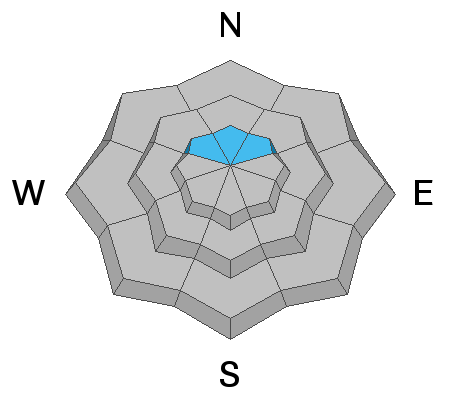
Here's where we are with our current snowpack. We had a couple of storms earlier in October and November. Lots of the snow from those early storms melted off but some remained on the north facing terrain above about 9500'. As this snow hung around through a long dry period, it "faceted" turning it into loose sugary grains. There was about 12" of this stuff on those high north slopes prior to the Thanksgiving storms. The Thanksgiving storms buried it with about a foot of new snow. I noted only a small amount of avalanche activity that happened during that storm. Now, we've just added another 16 to 24" of new snow on top of that weak sugary snow near the ground.
To be honest, I don't really know how that old snow is reacting to our new snow load. I have not been able to travel into any of this terrain to do analysis. What I do know is there was enough old weak snow to be a concern. Enough so that I recommend not getting into this terrain until we see what's going on.
It's easy to stay out of trouble right now. Simply avoid the steep northerly facing slopes above 9500'. There is A ton of terrain that doesn't fall into this category. I did some skiing on an east facing slope at about 9100' in elevation on Friday. There was no old snow there. It was bare ground prior to the Thanksgiving storms. The snowpack was completely stable there.
If you have questions about where you are, dig down and see if you find any "sugary" snow near the ground. If you find sugary snow, keep you slope angles under 30 degrees or go to a different slope.
Avalanche Problem #2
Wind Drifted Snow
Type
Location
Likelihood
Size
Description
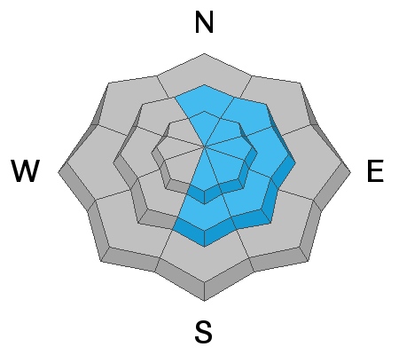
The bump in wind speeds may have drifted enough of the new snow to form some drifts which may be sensitive on their own. My best guess is this won't be all that much of an issue but keep an eye out for cracking in areas where you find thick fresh drifted snow.
Additional Information
General Announcements
I'll be publishing very basic avalanche information Monday through Friday.
I'll be publishing more detailed forecasts on Saturday and Sunday.