Forecast for the Skyline Area Mountains

Brett Kobernik
Issued by Brett Kobernik for
Sunday, January 9, 2022
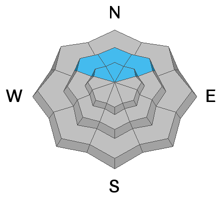
Avalanche conditions are relatively safe with the majority of the terrain having a LOW avalanche danger.
A CONSIDERABLE avalanche danger remains on upper elevation northwest, north and northeast facing slopes. It is still possible to trigger a deep and dangerous avalanche that breaks into weak snow near the ground.
Personally, I'm still avoiding steep slopes on the north half of the compass until I see the weak snow near the ground gain some more strength.
Low
Moderate
Considerable
High
Extreme
Learn how to read the forecast here
Special Announcements
FREE AVALANCHE AWARENESS CLASS!!
Thursday, January 13, 7pm
Big Pine Sports, Fairview, Utah
Dinner provided!!

Come learn more about avalanche safety. Topics include:
  • How to read avalanche terrain
  • Basic snowpack structure knowledge
  • How to use the daily avalanche forecast
  • Overview of manditory safety gear (beacon, shovel, and probe) as well as air bag information
  • Q & A to help with any questions you may have
Weather and Snow
Current Conditions
The minor storm that moved through early Saturday morning produced a bit more snow than I anticipated. Up to 5 inches of new snow stacked up. This was much needed to improve the wind blasted and sun baked snow surface. The new snow improved riding conditions greatly. Temperatures have really cooled off with canyon bottoms in the single digits and ridgelines in the teens. The wind has really slowed down also and is calm to light from the northwest.
Mountain Weather
High pressure takes hold today and we'll see sunny skies, temperatures up into the mid 20s and light west wind shifting more southerly. High pressure is the dominant weather feature for the foreseeable future. Anticipate mild, clear weather for a while.
Recent Avalanches
The last avalanche that we know of was on Jan 1st when a snowmobiler reportedly triggered a massive slide on Elderberry in Manti Canyon. This released on weak sugary faceted snow near the ground.
Ad
Avalanche Problem #1
Persistent Weak Layer
Type
Location
Likelihood
Size
Description
The weak sugary faceted snow at the base of the snowpack has gained some strength. The snowpack is slowly stabilizing. It is much less likely to trigger an avalanche at this time than a week ago. However, it is still possible. Slopes steeper than about 35 degrees on the mid and upper elevation northwest, north and northeast facing slopes are where you could find trouble. Snowpit tests still fail on the facets deep in the pack although the results are quite stubborn now. Keep in mind that if you trigger something it's going to be a deep avalanche with potentially serious consequences.

Persistent Weak Layer Summary, 2021-2022:
There was a foot or more of snow that fell in October.
This snow melted away on many slopes but it stayed on northwest, north and northeast facing slopes above about 8500'.
The snow that stayed turned into a weak sugary layer during dry weather in November.
We saw a large amount of snow in December which landed on top of the weak snow from October.
The weak layer of sugary faceted snow collapsed and produced avalanches under the stress of the large storms.
The weak layer is still present. We are monitoring it and are hopeful it will become more stable with time.
General Announcements
This forecast is from the U.S.D.A. Forest Service, which is solely responsible for its content. This forecast describes general avalanche conditions and local variations always occur.