Forecast for the Skyline Area Mountains

Mark Staples
Issued by Mark Staples for
Saturday, January 8, 2022
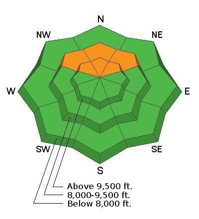
Today the avalanche danger is CONSIDERABLE on all northwest, north, and northeast facing slopes above 8000 ft that have old, rotten snow near the ground (a persistent weak layer). AVOID these slopes. All other slopes have a strong snowpack and a LOW danger because they don't have this weak layer near the ground.

It's really simple to avoid avalanches this weekend, but you have to know which direction the slopes you're riding on are facing. A slight change from east to northeast means one slope (like an east-facing one) doesn't have a dangerous weak layer, and another slope (like a northeast-facing one) does have it and can produce a large avalanche.
Scroll to the bottom to listen to a conversation Drew, Craig, and Nikki had with board member and ace interviewer Caitlin Hansen about weak layers, danger ratings, and what may lie ahead.
Low
Moderate
Considerable
High
Extreme
Learn how to read the forecast here
Special Announcements
FREE AVALANCHE AWARENESS CLASS!!
Thursday, January 13, 7pm
Big Pine Sports, Fairview, Utah
Dinner provided!!

Come learn more about avalanche safety. Topics include:
  • How to read avalanche terrain
  • Basic snowpack structure knowledge
  • How to use the daily avalanche forecast
  • Overview of manditory safety gear (beacon, shovel, and probe) as well as air bag information
  • Q & A to help with any questions you may have
Weather and Snow
Current Conditions
Yesterday under sunny skies temperatures climbed to near 40 degrees F in the hills, and the Salt Lake City Airport tied the daily high temperature record of 58 degrees previously set in 1956. Clouds returned yesterday afternoon, and very early this morning it started snowing with 2-3 inches near Fairview and Huntington Canyons. There may be an inch or two further south. A cold front is moving over the area this morning and temperatures are generally around 20 degrees F this morning with upper elevation winds blowing 23-27 mph gusting to 40 mph from the northwest.
Mountain Weather
Cold air behind the cold front will keep temperatures from warming beyond the mid-20s F today. Winds from the northwest will steadily diminish and skies will clear through the day. An additional inch or two of snow could fall this morning. Expect temperatures in the teens F tonight as skies clear with a cold start on Sunday morning. Sunday should have clear, sunny skies and almost no wind.
As for the snow....conditions took a beating from recent strong winds. Finding soft powder is getting harder. Exposed areas look like snow in the photo below. The good news is that the snowpack is very supportable (a big change from last winter) and has tons of traction for machines. There is still soft powder in the trees in sheltered areas although it may have a thin ice crust on in in places that got very warm yesterday.
Recent Avalanches
Yesterday Brett and I checked out a slide that buried a rider on January 1st in the south fork of Manti Canyon (video below). He was uninjured and supposedly buried to his waist. We found evidence of other slides from that same time frame, on north facing slopes that were generally wind loaded. This slide is a good example of what the snowpack is capable of producing. Even though it's getting less likely that avalanches like this will occur, we're not ready to touch this terrain because the potential avalanches will be so large.
Ad
Avalanche Problem #1
Persistent Weak Layer
Type
Location
Likelihood
Size
Description
  • Northerly facing slopes have a weak layer near the ground of old, rotten snow (facets) that produced a lot of slab avalanches like the one in the video above. Basically, when this weak layer fractures under the weight of a rider, it releases the entire snowpack and causes an avalanche.
  • Here's the situation - these avalanche problems don't heal overnight; instead, they gain just a little strength each day and get a little harder to trigger. What doesn't change is the size of the avalanches that will happen, and that's what makes this a dangerous situation.
  • The good news is that this layer is healing, we'll be watching it and keep you updated. Also, coverage is fantastic and there are lots of slopes to play on - just AVOID northwest, north, and northeast facing ones as though your life depends on it because it does.
    HEADS UP - Yesterday Brett and I tried to find this layer on east facing slopes, and we feel comfortable that it doesn't exist on those slopes. The challenge is that it's very easy to be riding on slopes that face southeast and east and then suddenly find yourself on a northeast facing slope that will killl you. It's easy to lose track of which directions are which, so pay attention.
General Announcements

This information does not apply to developed ski areas or highways where avalanche control is normally done. This forecast is from the U.S.D.A. Forest Service, which is solely responsible for its content. This forecast describes general avalanche conditions and local variations always occur.