Forecast for the Skyline Area Mountains

Brett Kobernik
Issued by Brett Kobernik for
Sunday, January 20, 2019
The avalanche danger remains CONSIDERABLE today. The snowpack is unstable in many areas and is especially dangerous on the north end of the Skyline which has received the most snow out of the last two storms. Human triggered avalanches are likely and could break up to 3 feet deep. Slopes over 30 degrees in steepness on the east half of the compass are the most suspect.
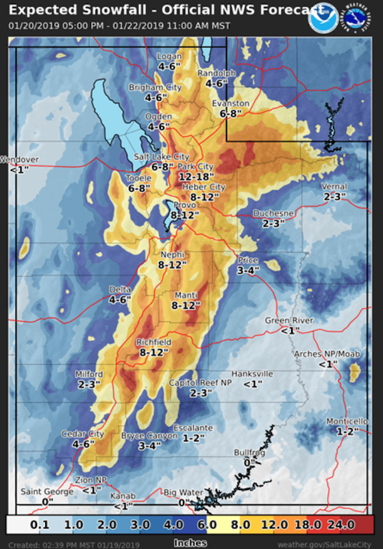
The avalanche danger will most likely reach HIGH on Monday during the next storm and we will have avalanche warnings issued for the Manti Skyline.
Low
Moderate
Considerable
High
Extreme
Learn how to read the forecast here
Weather and Snow
It's going to be partly cloudy today with increasing southwest wind as the day goes on. A storm is going to move through tonight into Monday bringing more snow. We could see about a foot of new snow Monday. Weather models indicate that the southern end of the Skyline may be favored with this storm.
Recent Avalanches
A large natural avalanche was reported from Lake Canyon. This released during the last storm. We don't have many details but one of the locals described it as "impressive".
The skier that was caught and buried in an avalanche on Friday near Electric Lake did not survive. He was found by rescuers around noon on Saturday.
ACCIDENT REPORT HERE.
Ad
Avalanche Problem #1
Persistent Weak Layer
Type
Location
Likelihood
Size
Description
Persistent Weak Layers of snow lurking in the snowpack remain our main concern today. The signs of danger are there:
  • Recent avalanches breaking into these persistent weak layers
  • Collapsing or "whoomping" of the snowpack continues
  • Cracking of the snowpack
  • Recent strong wind which loaded slopes with wind drifted snow
During the rescue operation on Saturday, everyone who was on snow was experiencing collapsing or "whoomping" of the snowpack. This tells us that the buried persistent weak layers are failing suddenly as we disturb the snow on top. All you need is a steep enough slope and these "whoomps" turn into avalanches.
Additional Information
This forecast is from the U.S. Forest Service, which is solely responsible for its content. This forecast describes general avalanche conditions and local variations always occur.