Forecast for the Skyline Area Mountains

Brett Kobernik
Issued by Brett Kobernik for
Saturday, January 19, 2019
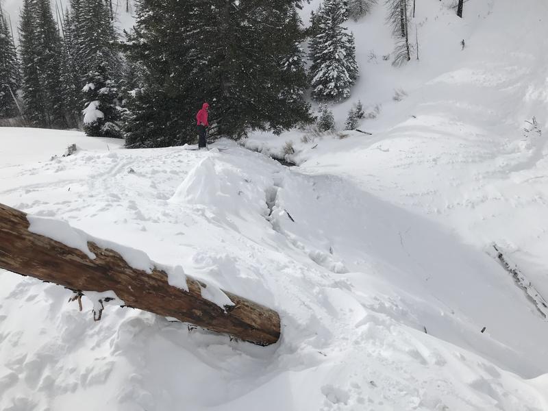
HUMAN TRIGGERED AVALANCHES ARE LIKELY AGAIN TODAY. The avalanche danger is CONSIDERABLE today. You will want to avoid slopes over 30 degrees in steepness especially if they have been loaded with wind drifted snow. The danger is higher on north, east and south facing slopes where the majority of the wind loading occurred.
Low
Moderate
Considerable
High
Extreme
Learn how to read the forecast here
Weather and Snow
A few more inches of snow trickled in Friday bringing totals up to 12" since Wednesday on the north end of the Skyline. The mid portion and southern end didn't receive quite as much. Wind was strong during the storm and transported quite a bit of snow.
Recent Avalanches
A man is still missing after presumably triggering an avalanche late in the day on Friday. He was skiing with a partner at the time. On their last ski run, he never came down to meet his partner. His partner walked back uphill a short distance and found the avalanche which he didn't know had released. Search and rescue teams are still trying to find him this morning. This was a large avalanche at least a couple of feet deep and extimated at 600 feet wide. PRELIMINARY ACCIDENT REPORT HERE.
There was some natural avalanche activity in Huntington Canyon early Friday morning also. One natural avalanche released on a steep road bank and spilled debris into the road blocking one lane temporarilly. Another larger avalanche released from one of The Camp Chutes, crossed the creek and came within 50 feet of the road. Photo below.
Ad
Avalanche Problem #1
Wind Drifted Snow
Type
Location
Likelihood
Size
Description
Strong wind created drifts which will be sensitive to the weight of a person again today. These drifts will mainly be found on more east facing slopes but watch for "crossloaded" terrain features on all aspects in the mid and upper elevations. Look for cornice formation which will indicate the slope below has been loaded. Watch for "pillowy" looking areas of snow which also indicate wind drifted snow. My partner and I noted shooting cracks during our travels on Friday which is also an indicator of unstable areas of wind drifted snow.
Avalanche Problem #2
Persistent Weak Layer
Type
Location
Likelihood
Size
Description
There are a few pre-existing weak layers of snow already in the snowpack which the new wind drifted snow is stressing. My partner and I noted "collapsing" or "whoomping" of the snowpack during our travel on Friday. This is Mother Nature's hint telling you that these buried weak layers are unstable. These layers were active last week resulting in a number of snowmobile triggered avalanches. Judging by the depth of the skier triggered avalanche on Friday, it is likely that we'll find that the avalanche failed on a buried Persistent Weak Layer of sugary snow.
Additional Information
This forecast is from the U.S. Forest Service, which is solely responsible for its content. This forecast describes general avalanche conditions and local variations always occur.