Forecast for the Salt Lake Area Mountains

Nikki Champion
Issued by Nikki Champion on
Tuesday morning, February 4, 2025
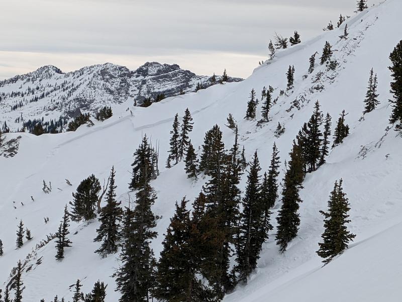
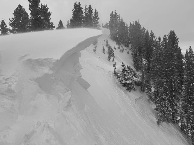
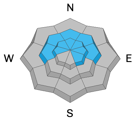
Avalanche danger is CONSIDERABLE at mid and upper elevations. Wind-drifted snow avalanches could be large and destructive, breaking on a buried weak layer beneath this weekend’s new snow and recent wind. These could be 1–3 feet deep, 100+ feet wide, and may step down to facets near the ground. Avalanches can be triggered remotely or from below, so stick to slopes under 30° and out of the wind zone.
Avoid large, overhanging cornices, as they can break farther back than expected.
At lower elevations, avalanche danger is MODERATE, with the risk of wet snow increasing as temperatures stay above freezing. If the snow becomes wet, unsupportable, or unstable, move to higher, cooler terrain.
CONSIDERABLE means human-triggered avalanches are likely. Travel with careful evaluation, cautious route-finding, and conservative decision-making today.
Low
Moderate
Considerable
High
Extreme
Learn how to read the forecast here
Special Announcements
We are sad to report that on February 3, 2025, a 37-year-old man from Evanston, Wyoming, died in an avalanche while snowmobiling in the Monte Cristo Area near the Rich and Cache County line. The victim’s friend called for help after being unable to locate him, prompting a multi-agency search that eventually found the buried victim. Our condolences go out to the victim's friends and family and all those affected by this tragic accident. Staff from the UAC will visit the site today to gather more information.
Weather and Snow
This morning, under partly cloudy skies, temperatures are warm. Trailhead temperatures range from the low to mid-40s °F, while the highest peaks sit around 30°F, briefly dipping below freezing. Winds are out of the south, shifting southeast in some areas, blowing 30–50 MPH with gusts into the 80s—even at mid-elevation ridgelines. There’s little difference in wind speeds between mid and high elevations today, as all zones are seeing strong winds.
The warm and windy pattern continues today. Skies will remain mostly cloudy, with temperatures rising into the upper 40s and low 50s °F. Winds will stay strong from the southwest—blowing 25 MPH, gusting to 35 MPH at mid-elevation ridgelines, and 45 MPH, gusting up to 75 MPH at the highest ridgelines. While winds will remain elevated for most of the day, they may start to ease this afternoon before moisture moves in.
A cold front arrives Wednesday morning, bringing a band of snow. Accumulations will be limited, with 0.40"–0.90" of water and 4"–9" of snow possible.
A stronger storm is expected Friday into Saturday, with forecasts currently calling for 1.2–2.2 inches of water and a higher-end scenario of around 2.6 inches. This system will also be colder, leading to lower-density snow as the storm progresses, especially after the cold front moves through.
Recent Avalanches
Yesterday was a quieter day in the backcountry, with only one reported avalanche in the Salt Lake area mountains. A skier-triggered hard slab avalanche occurred on a north-facing slope at 10,400' in Days Fork. Dropping a large cornice triggered a wind slab, which then stepped down to a faceted weak layer near the ground, breaking 300' across with depths of 1–3' in wind-loaded areas. A second, unexpected remote-triggered slide on an east-facing slope mirrored a previous avalanche from December. Multiple additional slides were observed on rollovers lower in the terrain, highlighting widespread instability. See photo below.
Ski areas saw widespread wind slab activity, with some slabs described as "meaty." Explosives triggered multiple D2 avalanches up to 3 feet deep, with some releasing unexpectedly in secondary terrain. Ski areas also reported wet loose avalanches at lower elevations, some gouging to the ground.
North-facing slope at 10,400' in Days Fork, 20 inches deep, 300 feet wide, triggered by wind-drifted snow on a faceted weak layer - Photo: Dindy
Check out all recent observations and avalanches HERE.
Ad
Avalanche Problem #1
Wind Drifted Snow
Type
Location
Likelihood
Size
Description
Winds remain strong at all elevations, forming both soft and hard slabs of wind-drifted snow on all aspects. These slabs rest on a weak, faceted snow surface in many areas and have not bonded well. Watch for pillow-shaped deposits and avoid them. Signs of instability—shooting cracks, collapsing, and overhanging cornices—are clear indicators of wind-drifted snow and unstable terrain.
High winds have transported snow farther downslope than usual, meaning wind drifts may be found lower off ridgelines than expected.
CORNICES should not be underestimated. Multiple cornice-triggered avalanches have been reported in the last two days. Limit exposure near ridgelines with cornices and slopes below them, as a cornice fall could trigger a larger wind slab or entrain significant snow onto the slope below.
Large cornices and wind drifted snow along ridgelines, that can trigger slope below - Davenport - Kelly
Avalanche Problem #2
Persistent Weak Layer
Type
Location
Likelihood
Size
Description
There are two buried weak layers in the snowpack:
  • The upper layer formed during last week’s cold, clear weather and isn’t bonding well to the newest snow or wind drifts. Most avalanches from the weekend broke on this layer, and it's the layer with the highest likelihood of triggering today.
  • The lower layer, near the ground, formed in December and has caused large avalanches, including two fatalities during the Holiday Avalanche Cycle. This layer is most likely to be triggered on steep, thin snowpack areas, rocky gullies, and repeater slopes (areas that have previously avalanched). Avalanches up to 1–4+ feet deep possible.
The avalanche page allows tracking of past avalanche cycles.

Read more about persistent weak layer avalanches HERE.
Avalanche Problem #3
Wet Snow
Type
Location
Likelihood
Size
Description
With above-average temperatures today, watch for wet loose avalanches at mid and lower elevations. The elevated winds yesterday seemed to keep much of the snow surface intact and may do the same today, but pay attention to wet snow conditions, as temperatures only briefly dropped below freezing last night.
While these slides are usually too small to bury you, buried facets near the ground create a small chance of a wet slab avalanche at lower elevations. Any dry snow avalanche reaching wet snow will be larger and more dangerous.
Warning signs of unstable wet snow include rollerballs, pinwheels, and a surface that’s no longer supportable. The avalanche risk will increase throughout the day as temperatures rise and into tomorrow if there’s no solid overnight refreeze and the potential for rain on snow.
General Announcements
This information does not apply to developed ski areas or highways where avalanche control is normally done. This forecast is from the U.S.D.A. Forest Service, which is solely responsible for its content. This forecast describes general avalanche conditions and local variations always occur.