Join us at our 2nd Annual Blizzard Ball

Forecast for the Salt Lake Area Mountains

Drew Hardesty
Issued by Drew Hardesty on
Monday morning, March 9, 2020
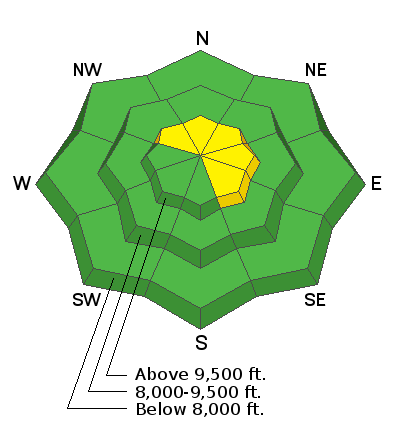
Most terrain has a LOW avalanche danger. A MODERATE danger for new wind drifts, however, can be found primarily along the upper elevations and most pronounced on steep northwest to northeast to southeast facing slopes. Sluffing is still possible in the steepest terrain. IF the sun pokes through or greenhousing occurs, wet avalanches will be likely.
Low
Moderate
Considerable
High
Extreme
Learn how to read the forecast here
Special Announcements
The UAC's Avy Awareness Auction is currently underway with tons of great gear, jewelry, artwork and experiences available. Visit the auction page HERE to help support the UAC's spring avalanche awareness and outreach efforts.

Join The Utah Avalanche Center at Backcountry HQ on March 12th as Craig Gordon leads an interactive discussion on current Wasatch snowpack conditions, a recap of this season’s close calls and accidents, how to stay on the right side of the fracture line, and predictions for the rest of the season. Space is limited, registration is required. Register HERE.
Weather and Snow
Skies are mostly cloudy-becoming-overcast. Mountain temps dropped to the low 20s overnight but have since rebounded into the mid to upper 20s in the pre-dawn hours. We should, however, have our best refreeze at the lower elevations since overnight of the 5th/6th.
Winds backed to the southwest around midnight and are blowing 15-20mph with gusts to 30mph. The most exposed anemometers have gusts to near 50.
Yesterday's storm over-delivered and the high density snow was just what we needed to mostly buffer the backcountry skier and rider from the old wind and sun crusts. Totals below:
LCC: 10"/0.75"SWE
BCC: 8-14"/0.6-1.0"SWE
PC ridgeline: 6-12"/0.5-0.88"SWE
(Note: SWE is snow-water-equivalent; ie: how much liquid water if you melted the snow)

For today, expect overcast skies with temperatures in the mid-20s up high, the mid-30s down low. Winds will be from the southwest, blowing 20mph along the ridgelines. The Ogden and Logan areas may see a trace to an inch during the day today.
Not much weather of great interest this week - off and on clouds, a flurry or two, etc with the potential of another storm system for late next weekend.
Recent Avalanches
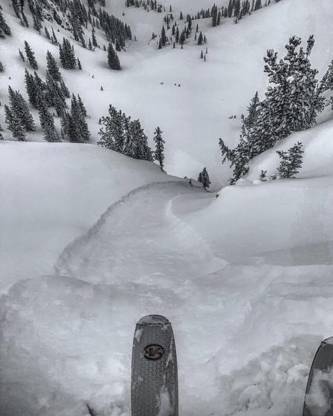
Only reported avalanche activity involved sluggish loose dry sluffs in steeper terrain with a few pockets of shallow soft slab initiated with ski cuts. (sluff photo by Mark White)
Ad
Avalanche Problem #1
Wind Drifted Snow
Type
Location
Likelihood
Size
Description
Newly developed wind drifts may be triggered primarily along the higher elevation bands. These will be most prominent on steep northwest to northeast to southeast facing slopes. These drifts should be reactive to cornice drops and ski cuts but best left alone and avoided. Look for the smooth and rounded, scalloped appearance of any wind drifts. These should become more stubborn as the day wears on.
Side Note: some areas received a fair bit of graupel with the storm. This graupel can bounce downhill and pool beneath cliffbands or at significant slope angle transitions (from very steep to moderate) and remain sensitive to provocation briefly after a storm.
Additional Information
Wet snow avalanches can be exceptionally challenging to forecast. The lowest elevation refreeze (frozen crust) sits above weak, unconsolidated and unsupportable wet grains. If this crust thaws today, it may be possible to trigger wet sluffs in the lower elevation bands. Pay attention to how the snow is behaving under your feet. Avoid being in or above terrain traps and steep walled gullies.
General Announcements
This information does not apply to developed ski areas or highways where avalanche control is normally done. This forecast is from the U.S.D.A. Forest Service, which is solely responsible for its content. This forecast describes general avalanche conditions and local variations always occur.