Join us at our 2nd Annual Blizzard Ball

Forecast for the Salt Lake Area Mountains

Nikki Champion
Issued by Nikki Champion on
Sunday morning, March 8, 2020
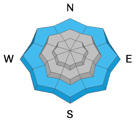
This morning the avalanche danger will rise to MODERATE on all aspects and elevations. Today's new snowfall may create sensitive storm snow at the mid and upper elevations. This could include long-running sluffs, shallow storm slabs, and isolated areas of wind-drifted snow.
Wet loose avalanches are also possible on all low elevation slopes where rain and wet snow may be falling on an already wet snow surface.
Pay attention to changing conditions and continue to evaluate snow and terrain carefully.
Low
Moderate
Considerable
High
Extreme
Learn how to read the forecast here
Special Announcements
The UAC's Avy Awareness Auction is currently underway with tons of great gear, jewelry, artwork and experiences available. Visit the auction page HERE to help support the UAC's spring avalanche awareness and outreach efforts.

Join The Utah Avalanche Center at Backcountry HQ on March 12th as Craig Gordon leads an interactive discussion on current Wasatch snowpack conditions, a recap of this season’s close calls and accidents, how to stay on the right side of the fracture line, and predictions for the rest of the season. Space is limited, registration is required. Register HERE.
Weather and Snow
This morning, mountain temperatures are in the low 30s F at trailheads and mid to low 20s F at ridgelines. Winds are currently Southwesterly and averaging 15-30 mph, with gusts in the upper 20s - low 40s mph at most elevations. At the highest elevation gusts are above 60 mph. Snow has lightly begun to fall this morning, with totals between 1-3 inches so far in the Central Wasatch.
Today, a weak weather system is moving through the area and will bring light to moderate snowfall throughout the morning into the early afternoon. Temperatures will be in the mid to upper 30s F at trailheads and upper 20s F at ridgelines. Winds will shift to west southwesterly and average 5-15 mph with gusts up to 30 mph at the highest ridgelines. The storm totals for this weather system could be 2-5 inches for the central Wasatch.
This snow will be falling on a wide-spread of snow surfaces. Most aspects will now possess a firm crust, where the previously wet snow surface had a proper refreeze. The exception will be the upper elevation north facing terrain that still had some soft snow before this storm. Take note of the previous snow surfaces as the snow totals begin to grow.
Recent Avalanches
A few small wet-loose avalanches reported in the backcountry yesterday. This includes a small natural cycle that was seen yesterday afternoon on the Coalpit Headwall. See the full observation HERE.

Our Week in Review - where we summarize snow, weather, and avalanche activity over the past week, is available HERE.
Ad
Avalanche Problem #1
New Snow
Type
Location
Likelihood
Size
Description
This morning's snow has begun falling on a variety of snow surfaces in the backcountry. Light to moderate snowfall throughout the day may lead to periods of sensitive storm snow.
  • This will include long-running sluffs on all aspects. Winds should be decreasing but these sluffs could be especially prevalent in wind-drifted terrain features such as ridgelines and cross-loaded gullies. Even a small slide can have serious consequences in big, steep terrain or if you’re above cliffs.
  • This could also include sensitive storm slabs on upper elevation north facing terrain that harbored dry snow before the storm, and any aspect during periods of highest intensity snowfall. Watch for obvious signs of instability such as cracking and sluffing.
Today it will be important to pay attention to changing conditions such as higher snowfall rates than predicted and elevated winds. Increased snowfall rates or increased winds will mean increased avalanche danger.
Avalanche Problem #2
Wet Snow
Type
Location
Likelihood
Size
Description
This morning's rising temperatures and lack of proper refreeze at lower elevations mean that wet snow or rain could be falling on an already wet snow surface. This could lead to wet loose avalanches on all aspects of the lower elevation bands.
Avoid traveling on or below steep terrain features at the lower elevations.
The key for today will be to climb to higher elevations where there was a proper refreeze, and you no longer find wet snow underneath today's new snow.
General Announcements
This information does not apply to developed ski areas or highways where avalanche control is normally done. This forecast is from the U.S.D.A. Forest Service, which is solely responsible for its content. This forecast describes general avalanche conditions and local variations always occur.