March Kicks Off Our Spring Campaign- Donate Now to Support Forecasting

Forecast for the Salt Lake Area Mountains

Dave Kelly
Issued by Dave Kelly on
Saturday morning, March 8, 2025
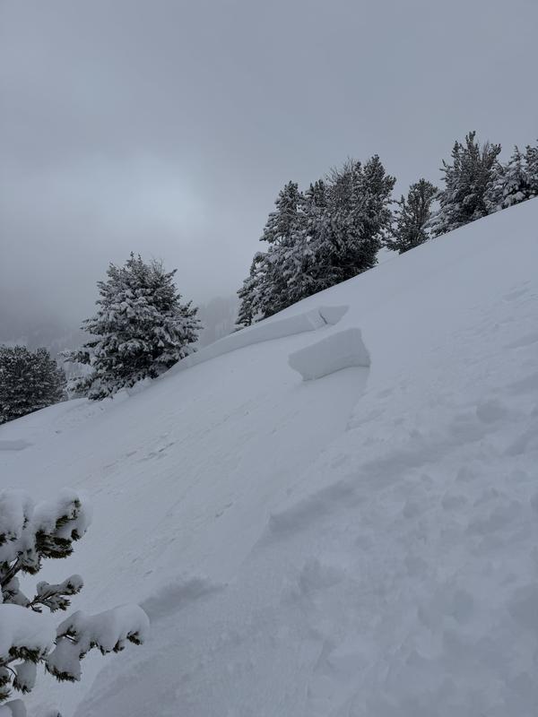
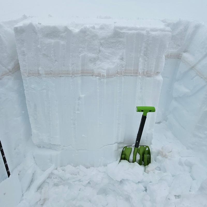
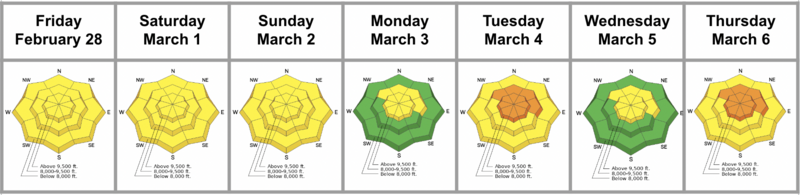
The avalanche danger is CONSIDERABLE on steep northwest-north-east facing mid and upper elevation slopes where it is likely that humans will trigger an avalanche failing on small grained facets associated with the old snow surface, which is marked by a dirt layer. There is also the chance that a human could trigger an avalanche failing on a layer of facets formed in December. These avalanches could be 2'-4' deep.
The avalanche danger is MODERATE on all other aspects where we may see wet snow avalanches with the first hint of sun. This wet snow problem is a matter of timing with the danger of these avalanches rising to CONSIDERABLE throughout the day. Start early and get off of slopes in the sun as they start to heat up.
Roofs in mountain neighborhoods are likely to shed their snow today, check in on children playing or shovelers under roof lines.
Low
Moderate
Considerable
High
Extreme
Learn how to read the forecast here
Special Announcements
March kicks off our Spring Campaign! If everyone in Utah’s backcountry community donates the cost of something they regularly enjoy on an adventure—like a dawn patrol burrito, a backpack snack, or post-ride trailhead drinks—we could fund not just one but two forecasters for the entire season! Donate here. Thank you!
Weather and Snow
Currently, under clear skies temperatures are in the single digits °F. Winds are blowing lightly from the north-east at the lower ridgelines and from the north in the 20's at the highest ridgelines. There was a trace of new snow recorded as the storm exited the region last night. Snow totals for the most recent storm are anywhere from 12"-26 of snow and 1"-2" of water.
Today, look for clear skies with temperatures from 32-37°F and winds blowing lightly from the north at the lower elevations and 20 gusting to 25 MPH at the highest peaks.
Since March 2nd the storm totals are 2'-4' of snow and 2"-5" of water. A good marker for the start of this storm is a layer of dust that is now 2'-3' down from the surface.
Recent Avalanches
Yesterday, we had reports of human triggered avalanches on Kessler and in Days Fork, and a hiker caught and carried on Mt. Olympus. Some of these avalanches were wind-drifted snow avalanches failing near the dirt layer that formed the evening of March 2nd.
Photo (John C) of an avalanche triggered from the ridge in Days Fork.

Check out all avalanches and observations HERE.
Ad
Avalanche Problem #1
Persistent Weak Layer
Type
Location
Likelihood
Size
Description
Over the last week we have had 2'-4' feet of snow. The start of this storm is marked by a layer of dirt that is harboring weak faceted snow. This layer is not yet settled out and yesterday we had reports of riders triggering avalanches failing on this dusty interface.
The other layer of concern is the same one we have been talking about since the Holidays. This layer of sugary faceted snow formed near the ground and has been the culprit in a number of avalanche fatalities in Utah this season. This layer near the ground will now be 2'-4' deep and any avalanche failing here would be large enough to bury, injure, or kill a person. Slopes that are most likely to holding this layer are thinner, shallower, and have potentially already avalanched a couple of times this season (repeaters). The best way to find out if this layer exists is to take your probe out and check snow depths before committing to steep terrain.
Photo (Manship and Collet) showing the dirt layer now buried 2'-4' below the surface.
Avalanche Problem #2
Wet Snow
Type
Location
Likelihood
Size
Description
Today, with the full sun expect to see wet snow avalanches. These will be more likely on steep southerly facing slopes at all elevations and in the low elevation northerly facing terrain and may entrain all the new storm snow running on the dirt interface. These avalanches can be managed with timing. Get off of steep slopes in the sun as they begin to warm up where the danger could rise to CONSIDERABLE and natural wet avalanches will be possible.
Roof slides are on my radar today. Pay close attention to children playing or shovelers near roof lines as many mountain neighborhoods have not yet had enough sun to shed the most recent storm snow and today will be the day.
Additional Information
Check out the Week in Review HERE.
General Announcements
This information does not apply to developed ski areas or highways where avalanche control is normally done. This forecast is from the U.S.D.A. Forest Service, which is solely responsible for its content. This forecast describes general avalanche conditions and local variations always occur.