
Nikki Champion
Forecaster
Week in Review: Avalanche Conditions and Snowpack Developments (February 28 - March 6, 2025)
Each week, we look back at the key snowfall, weather, and avalanche events from the previous week. For archived forecasts, visit the Salt Lake Mountains’ past updates.
Overall Summary:
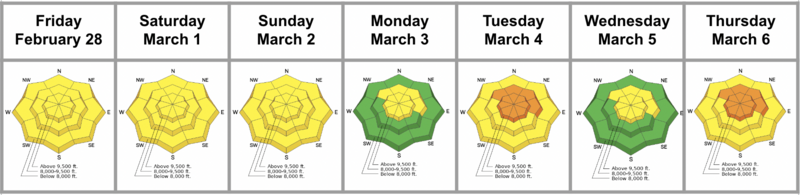
It was a week of transition in the Salt Lake mountains, starting with warm, sunny weather and MODERATE avalanche danger before a series of storms brought winter back in full force. Early in the week, riders continued to trigger 2–4 ft deep avalanches on a persistent weak layer, primarily on NW–E slopes at mid and upper elevations. Daytime heating led to widespread wet loose activity on sunny aspects and lower-elevation shady slopes, while glide avalanches released in Broads Fork, Mill B South, and Stairs Gulch. Snow surfaces varied between crust, slush, and isolated soft turns, but a major shift loomed on the horizon.
By Monday night, storms ramped up, delivering 1–2 feet of snow and increasing avalanche danger. Strong winds formed sensitive wind slabs, and CONSIDERABLE danger developed in wind-loaded terrain. The persistent weak layer remained a concern, particularly in shallow or previously avalanched areas, while storm snow created loose snow and slab avalanche problems elsewhere. By midweek, wind-drifted slabs lingered at upper elevations, but conditions began stabilizing.
By Thursday, the storm brought more snow and wind, further elevating avalanche danger to CONSIDERABLE at mid and upper elevations, with human-triggered avalanches likely. The day saw a mix of storm slabs, wet loose avalanches, and some slides stepping down into a dust layer. Explosive mitigation triggered D2 storm slabs, while natural activity was observed throughout the day.
Friday, February 28
It was a warm, sunny day in the Salt Lake mountains with MODERATE avalanche danger. Riders triggered 2–4 ft deep avalanches on mid and upper-elevation NW–E slopes due to a persistent weak layer, while rising temperatures led to both natural and human-triggered wet avalanches on sunny aspects and some lower-elevation shady slopes. Glide avalanches released in Broads Fork, Mill B South, and Stairs Gulch. The snowpack was mostly crusty, though solar slopes softened in the afternoon. A significant shift was on the horizon.
It was a warm, sunny day in the Salt Lake mountains with MODERATE avalanche danger. Riders triggered 2–4 ft deep avalanches on mid and upper-elevation NW–E slopes due to a persistent weak layer, while rising temperatures led to both natural and human-triggered wet avalanches on sunny aspects and some lower-elevation shady slopes. Glide avalanches released in Broads Fork, Mill B South, and Stairs Gulch. The snowpack was mostly crusty, though solar slopes softened in the afternoon. A significant shift was on the horizon.
The spread of snowpack depths we were seeing across the range - in some places 6+ feet deep - on repeater slopes, much shallower - Mineral Fork
Saturday, March 1
Another warm, sunny day kept MODERATE avalanche danger in place. While the persistent weak layer on mid and upper-elevation NW–E slopes was becoming less reactive, triggering a 2–4 ft deep avalanche was still possible, particularly in thinner snowpack areas. Daytime heating made wet loose avalanches likely on sunny aspects and lower-elevation shady slopes—rollerballs and unsupportive, slushy snow were key warning signs. Glide avalanches remained a concern in Broads Fork, Mill B South, and Stairs Gulch. The snow surface varied between crust, slush, and isolated soft turns.
Another warm, sunny day kept MODERATE avalanche danger in place. While the persistent weak layer on mid and upper-elevation NW–E slopes was becoming less reactive, triggering a 2–4 ft deep avalanche was still possible, particularly in thinner snowpack areas. Daytime heating made wet loose avalanches likely on sunny aspects and lower-elevation shady slopes—rollerballs and unsupportive, slushy snow were key warning signs. Glide avalanches remained a concern in Broads Fork, Mill B South, and Stairs Gulch. The snow surface varied between crust, slush, and isolated soft turns.
Sunday, March 2
Avalanche danger remained MODERATE across all elevations. The persistent weak layer lingered on NW–E slopes, where 2–4 ft deep avalanches were still possible, particularly in areas with a shallow snowpack. Glide avalanches continued to be a concern in Broads Fork, Mill B South, and Stairs Gulch. A storm was set to arrive overnight, bringing strong winds and up to 1–2 feet of snow by Tuesday, signaling a return to winter conditions.
Avalanche danger remained MODERATE across all elevations. The persistent weak layer lingered on NW–E slopes, where 2–4 ft deep avalanches were still possible, particularly in areas with a shallow snowpack. Glide avalanches continued to be a concern in Broads Fork, Mill B South, and Stairs Gulch. A storm was set to arrive overnight, bringing strong winds and up to 1–2 feet of snow by Tuesday, signaling a return to winter conditions.
Example of the wet snow instabilities from the Sessions
Monday, March 3
Avalanche danger remained MODERATE across the Salt Lake mountains, with two primary concerns. A 2–4 ft deep avalanche on the persistent weak layer was still possible, especially on NW–E aspects and some upper-elevation W and SE slopes. While these layers became less reactive, they remained a threat in shallow or previously avalanched terrain. In addition, shifting winds and fresh snowfall created sensitive wind-drifted slabs at upper elevations. Light snow in the afternoon transitioned to heavier snowfall overnight.
Avalanche danger remained MODERATE across the Salt Lake mountains, with two primary concerns. A 2–4 ft deep avalanche on the persistent weak layer was still possible, especially on NW–E aspects and some upper-elevation W and SE slopes. While these layers became less reactive, they remained a threat in shallow or previously avalanched terrain. In addition, shifting winds and fresh snowfall created sensitive wind-drifted slabs at upper elevations. Light snow in the afternoon transitioned to heavier snowfall overnight.
Tuesday, March 4
The storm produced 1.6” of water in the morning. Avalanche danger rose to CONSIDERABLE on upper-elevation slopes and mid-elevation NW–E aspects, where strong winds and new snow created dangerous avalanche conditions. A 2–4 ft deep avalanche on the persistent weak layer remained possible, particularly in shallow or previously avalanched terrain. Elsewhere, the danger was MODERATE as heavy snowfall and increasing winds heightened avalanche conditions. Outside wind-loaded terrain, loose snow and soft slab avalanches were possible within the new storm snow. Winds shifted W–NW, transporting snow and forming fresh, reactive wind slabs. Final snow totals were up to 2.5” of water—a heavy hitter. Ski area avalanche teams and observers reported active wind slab and storm slab instabilities in the morning hours. By afternoon, things had largely settled out.
The storm produced 1.6” of water in the morning. Avalanche danger rose to CONSIDERABLE on upper-elevation slopes and mid-elevation NW–E aspects, where strong winds and new snow created dangerous avalanche conditions. A 2–4 ft deep avalanche on the persistent weak layer remained possible, particularly in shallow or previously avalanched terrain. Elsewhere, the danger was MODERATE as heavy snowfall and increasing winds heightened avalanche conditions. Outside wind-loaded terrain, loose snow and soft slab avalanches were possible within the new storm snow. Winds shifted W–NW, transporting snow and forming fresh, reactive wind slabs. Final snow totals were up to 2.5” of water—a heavy hitter. Ski area avalanche teams and observers reported active wind slab and storm slab instabilities in the morning hours. By afternoon, things had largely settled out.
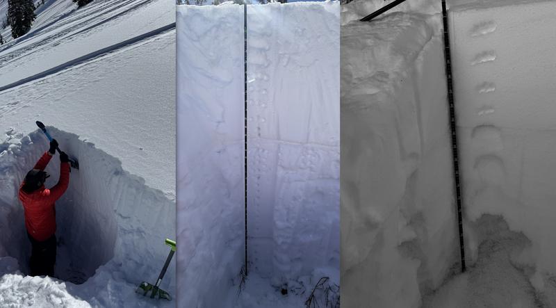
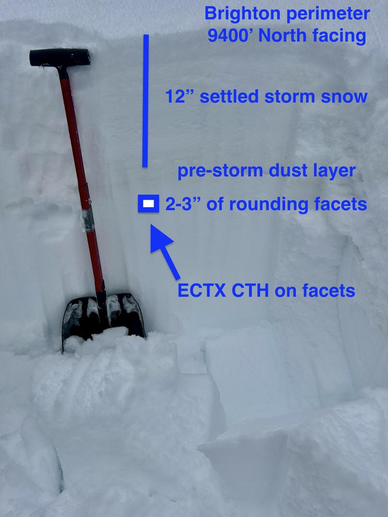
Noticing a few faceted grains beneath a dust layer - Brighton perimeter
Wednesday, March 5
Avalanche danger remained MODERATE at mid and upper elevations, where lingering 12–18” wind slabs could still be triggered but were expected to stabilize throughout the day. In isolated areas facing W–N–SE, the persistent weak layer remained a concern, particularly in steep, rocky terrain or repeater avalanche paths. Elsewhere, the danger was LOW. Only some dry sluffing was reported.
Avalanche danger remained MODERATE at mid and upper elevations, where lingering 12–18” wind slabs could still be triggered but were expected to stabilize throughout the day. In isolated areas facing W–N–SE, the persistent weak layer remained a concern, particularly in steep, rocky terrain or repeater avalanche paths. Elsewhere, the danger was LOW. Only some dry sluffing was reported.
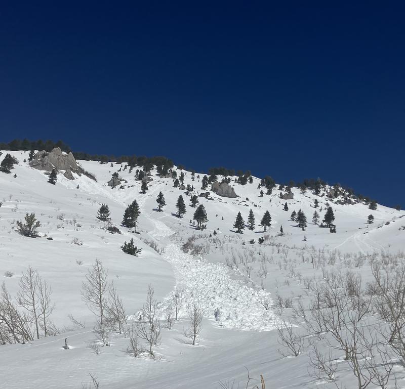
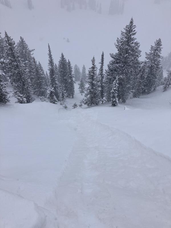
Example of easy sluffing seen in Silverfork during the storms - DB
Thursday, March 6
Avalanche danger was CONSIDERABLE at mid and upper elevations, with human-triggered avalanches likely and natural avalanches possible during periods of heavy snowfall. A strong storm brought steady snowfall overnight, favoring areas along the Park City Ridgeline and upper Big Cottonwood Canyon, with totals ranging from 8 to 14 inches by morning. Winds shifted from the southeast to southwest, averaging 20-25 mph with gusts near 30 mph, transporting snow and forming soft wind slabs on leeward slopes. Temperatures remained in the mid-20s but gradually warmed through the day, contributing to increased instability. The avalanche cycle included a mix of storm slabs, wet loose avalanches, and some slides stepping down to older weak layers. Storm slabs were reactive at all elevations, failing at the new/old snow interface and propagating easily. Lower elevations saw widespread wet loose avalanches as warming destabilized the new snow. Some slides stepped down to the 3/2 dust layer, producing long-running D2 avalanches. Explosive mitigation triggered numerous D2 storm slabs, while natural activity was observed throughout the day.
Test
giantrabbit
Thu, 6/12/2025
- reply


