Donate to Our Spring Campaign or Bid on our Spring Auction to Support Forecasting

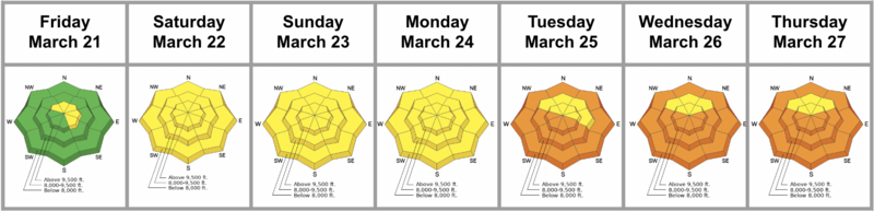
Forecast for the Salt Lake Area Mountains

Greg Gagne
Issued by Greg Gagne on
Friday morning, March 28, 2025
The avalanche danger will rise to MODERATE on most slopes where wet, loose avalanches can be expected, especially at the low and mid-elevations. Larger wet slab avalanches are also possible. Specific terrain where glide avalanches can occur should be avoided. Upper-elevation northerly aspects have a LOW danger.
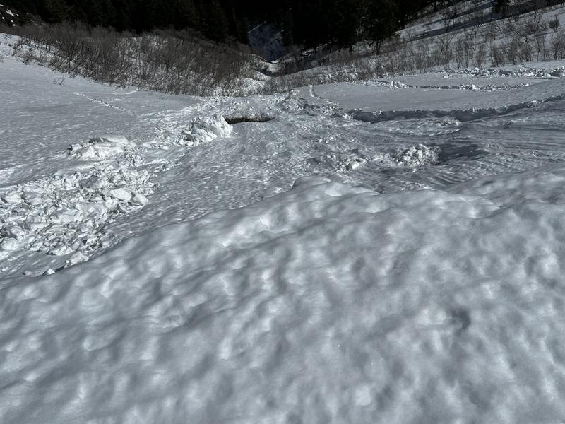
Timing is everything: once the slope you are on or below becomes soft and unsupportable, move to a cooler, supportable aspect.
Low
Moderate
Considerable
High
Extreme
Learn how to read the forecast here
Special Announcements
Our Spring Campaign is in full swing, and there are two great ways to support forecasting, awareness, and education across Utah: Donate to our Spring Campaign, or Bid on items in our Spring Auction. Every dollar donated helps keep the backcountry community on top.
Weather and Snow
Conditions are all time(!) ....... if you are drawn to the backcountry to seek solitude.
This Morning: Temperatures are 25°-30° F with low-elevation trailheads in the low 30's F. This is the first night of below-freezing temperatures in a few days. Winds are from the south/southwest and gusted to ~50 mph overnight at the upper elevations, but have relaxed and are now gusting in the 20's mph. Some light rain showers have been reported as high as 8,000'.
Today: Mostly cloudy skies with temperatures rising into the upper 30's F. Winds will be from the southwest, gusting into the 20's mph above 9,000', with gusts in the 30's at the highest elevations. There is a chance of a few rain and snow showers this afternoon.
Overnight and into Saturday: Cooler temperatures and snow developing Saturday afternoon, with 6-8" of new snow by late Saturday. A break on Sunday, with a more substantial storm for late Monday. The first week of April looks active with a return to winter.
Recent Avalanches
Wet, loose avalanches were reported on Thursday, including a large wet avalanche in Coalpit Gulch on a low-elevation northerly aspect.
Wondering what the warm temperatures have meant for avalanches and the snowpack this past week? Check out Nikki's Week in Review for details.
Ad
Avalanche Problem #1
Wet Snow
Type
Location
Likelihood
Size
Description
I'm uncertain how our wet snowpack will react today as it will depend upon cloud cover, winds, and temperatures. Colder, subfreezing temperatures and winds have cooled the snowpack, but natural and human-triggered avalanches involving wet snow can be expected. The specific wet snow issues for today are:
1. Wet loose avalanches on all aspects, especially at the low and mid elevations where the "refreeze" is less prominent.
2. Wet slab avalanches - particularly on aspects facing west/south/east at the low and mid elevations, but possibly some northerly aspects - where meltwater may "pool" and weaken the snow at various crust interfaces.
3. Cornices may collapse naturally, possibly triggering an avalanche on the slope below. (See photo)
4. Glide avalanches are a concern in Stairs Gulch, Broads Fork, Mill B South of Big Cottonwood, and the Raymond Slabs in upper Porter Fork in Millcreek Canyon and this terrain should be avoided.
5. Roofs may naturally release their snow - please keep kids, other people, and animals away from underneath steep roof lines.

Photo of wet avalanche triggered from a natural cornice fall:
General Announcements
This information does not apply to developed ski areas or highways where avalanche control is normally done. This forecast is from the U.S.D.A. Forest Service, which is solely responsible for its content. This forecast describes general avalanche conditions and local variations always occur.