Donate to Our Spring Campaign or Bid on our Spring Auction to Support Forecasting

Forecast for the Salt Lake Area Mountains

Dave Kelly
Issued by Dave Kelly on
Sunday morning, March 23, 2025
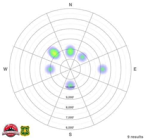
There is a MODERATE avalanche danger today where it will be possible for humans to trigger wind-drifted snow avalanches in steep (greater than 35°) mid and upper elevation terrain. Wet snow avalanches will be likely on east-south-west facing slopes and in low elevation northerly facing terrain.
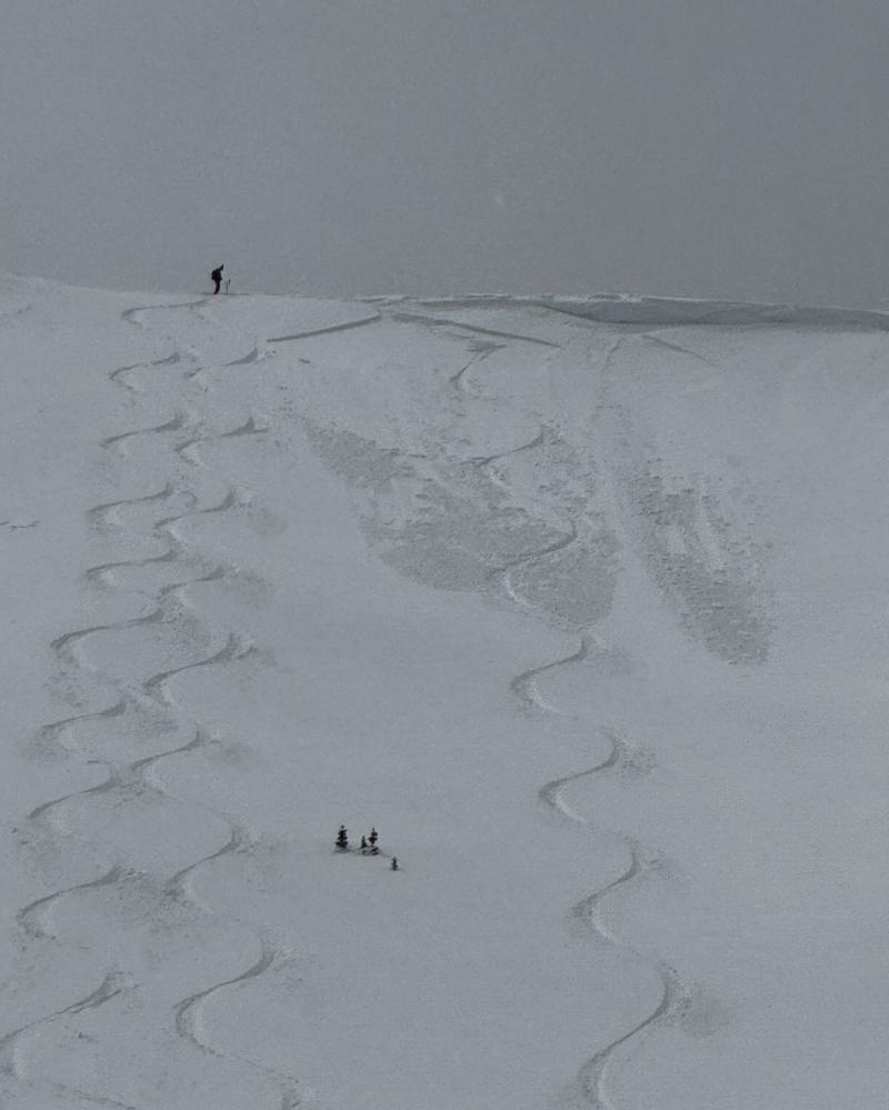
Today's wet snow problem is matter of timing, avoid steep slopes during daytime warming, as recent storm snow will become damp and come down the mountain. Steep gully features facing south and west are prime places for humans to be involved with naturally-triggered wet snow avalanches.
Start early and finish early to avoid the wet snow problem.
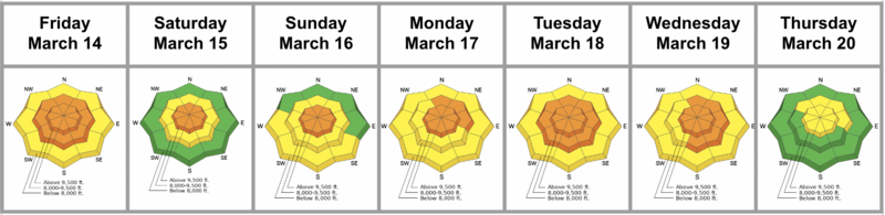
Low
Moderate
Considerable
High
Extreme
Learn how to read the forecast here
Special Announcements
Our Spring Campaign is in full swing, and there are two great ways to support forecasting, awareness, and education across Utah: Donate to our Spring Campaign, or Bid on items in our Spring Auction. Every dollar donated helps keep the backcountry community on top.
Weather and Snow
Currently, under partly cloudy skies temperatures are in the low teens to mid 20's °F. Winds are blowing from the west-northwest in the teens gusting to the 30's MPH at the lower ridgelines and from the west-northwest in the 40's gusting to the 60's MPH at the highest ridgelines. Storm totals range from 2"-5" of snow and .20"-.67" of snow water equivalent (SWE). The new snow that fell was mostly graupel and rimed precipitation particles and it made for a great refresh with the wind helping to fill in old tracks in the backcountry.
Today, look for partly cloudy skies with increasing sun this afternoon. Temperatures will be in the high 30's °F to the low 40's °F Winds are forecast to blow from the northwest 15 gusting to 20 MPH at the 9,000' ridgelines and from the northwest 25 gusting to 35 MPH at the 11,000' ridgelines. Winds are currently gusting to the 60's MPH at the highest ridgelines, but this should decrease through the morning.
Recent Avalanches
Yesterday, we had reports of sensitive new snow and shallow wind-drifted avalanches that were easily triggered by riders and cornice falls. These avalanches were failing on the old/new snow interface or a density change within the newest snow and in some cases running on a melt-freeze crust. There were riders involved in shallow avalanches in the Twin Lakes Pass area, Patsy Marly, north facing Mt Wolverine, and south facing Mt Wolverine/Tuscarora. There were also second-hand reports of avalanches involving riders on Patsy Marley and Flagstaff Shoulder and natural avalanches in the Y-Couloir. There were a number of other avalanches also reported to the Utah Avalanche Center. You can check out all recent observations and avalanches HERE.
Photo (M. White) of an intentionally skier triggered wind-drifted snow avalanche in South Monitor.
Ad
Avalanche Problem #1
Wet Snow
Type
Location
Likelihood
Size
Description
The danger will rise today and may reach CONSIDERABLE for wet snow avalanches, which are likely to occur on easterly, southerly, and westerly facing slopes and on low elevation north facing slopes. This problem can be managed with timing. Get off of steep slopes as the day warms up. Steep gully features and rocky terrain are likely places to see wet snow avalanches.
The likelihood for wet snow avalanches will increase today, and you are likely to see natural wet snow avalanches on steep south and west facing terrain this afternoon.
If you're getting an early start, check out our dawn patrol hotline that is updated every morning by 530AM; 888-999-4019 option 6.
Avalanche Problem #2
Wind Drifted Snow
Type
Location
Likelihood
Size
Description
Expect to see drifts of wind-blown snow on the downwind side of ridgelines and terrain features. The wind-drifted snow has created soft and sensitive cornices on the ridgelines and these cornices may break further back than you expect and trigger soft slab avalanches below them.
Look for and avoid pillowy, wind loaded features and if you see cracking or collapsing than move to lower angle terrain. Only expose one rider to a time to wind-drifted snow features while ascending or descending steep gullies.

Avalanche heat map above showing the widely distributed wind-drifted snow avalanches from yesterday. This map shows how swirly wind can be in the mountains; loading steep slopes at most aspects in the mid and upper elevation terrain band regardless of wind direction.
Today, these wind drifts will be more stubborn and allow you to get further onto the slope before potentially breaking above you. This is a bigger concern in extreme no-fall terrain such as hanging snowfields and exposed gully features.
Additional Information
What happened to the persistent weak layer (PWL)? We encourage you to take the time to read this blog post discussing the PWL and how it may return.
Check out the Salt Lake Region Week in Review HERE.
General Announcements
This information does not apply to developed ski areas or highways where avalanche control is normally done. This forecast is from the U.S.D.A. Forest Service, which is solely responsible for its content. This forecast describes general avalanche conditions and local variations always occur.