March Kicks Off Our Spring Campaign- Donate Now to Support Forecasting

Forecast for the Salt Lake Area Mountains

Nikki Champion
Issued by Nikki Champion on
Monday morning, March 10, 2025
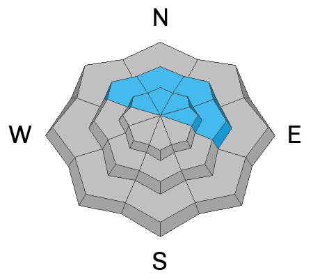
The avalanche danger is MODERATE on steep northwest, north, and northeast-facing slopes at mid and upper elevations, where human-triggered avalanches on one of two buried weak layers are possible. These avalanches could be 1–4 feet deep, and hundreds of feet wide.
While the likelihood of triggering one of these instabilities fits within the MODERATE category, the consequences remain much higher.
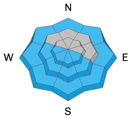
The avalanche danger will also rise to MODERATE on all other aspects due to wet snow avalanches with daytime warming. This problem is all about timing—the danger will increase throughout the day as the sun heats the snow. Start early, pay attention to signs of warming, and get off solar slopes before they become unstable.
Low
Moderate
Considerable
High
Extreme
Learn how to read the forecast here
Special Announcements
We are heartbroken to confirm that 51-year-old Micheal Janulaitis of Marion, Utah, was killed in an avalanche on Friday, March 7th, near Hoyt Peak. Micheal was caught and carried while skiing a steep, northeast-facing run in Hoyt Bowl. Our deepest gratitude to the Department of Public Safety, Park City Mountain Resort and Canyons Village Snow Safety and Ski Patrol teams, and Wasatch Backcountry Rescue for their efforts in recovering Micheal and bringing him home to his family. Micheal was a friend of the UAC, and we are grateful for the time we shared. This is a tremendous loss for our backcountry community, and he will be deeply missed.
We are compiling accident details and a preliminary report can be found HERE.
March kicks off our Spring Campaign! If everyone in Utah’s backcountry community donates the cost of something they regularly enjoy on an adventure—like a dawn patrol burrito, a backpack snack, or post-ride trailhead drinks—we could fund not just one but two forecasters for the entire season! Donate here. Thank you!
Weather and Snow
Today's snow, weather, and recent avalanche activity was written by Jeremy Collett, the Utah Avalanche Center KBYG Coordinator.

Current Conditions: At 5 AM, the skies are clear, and temperatures are slightly inverted. Lower elevation trailheads are in the upper teens, while temperatures at higher elevations are in the upper 20s °F, approaching freezing. Overall, temperatures are a few degrees warmer today than they were at this time yesterday. Winds have increased over the past 12 hours, with speeds in the teens (mph), gusting into the 20s from the West and Southwest. At the highest elevations, winds are in the teens, gusting into the 30s and 40s, with the highest gusts recorded in the 50s.
Today: Weather will be similar to yesterday, with clear skies and temperatures warming into the mid to upper 40s °F. Winds will be from the southwest. At the 9,000-foot ridgelines will be 10-15 mph, gusting to 25 mph, and at 11,000-foot ridgelines, gusts will average 35 mph with occasional stronger gusts.
Looking Ahead: The next storm is expected to move into the area on Wednesday, potentially bringing 1.5” to 2.5” of SWE and 18-36” of snow by Friday.
Snow Conditions: With warm temperatures yesterday, you can expect a solid crust on east, south, and west-facing slopes at all elevations this morning. The snow surface will likely turn to mush quickly due to strong sun and warm temperatures. However, it’s still possible to find cold snow on northerly aspects at mid to upper elevations.
Recent Avalanches
Over the past two days, there have been numerous reports of natural and skier-triggered wet-loose avalanches on southerly and westerly slopes during afternoon warming. This includes a close call in the White Pine Chute on Saturday. These avalanches ranged in size from small to relatively large, with some that entrained quite a bit of snow and could easily bury a human.

Check out all avalanches and observations HERE.
Ad
Avalanche Problem #1
Persistent Weak Layer
Type
Location
Likelihood
Size
Description
There are two persistent weak layers of concern in the backcountry right now:
  1. The first layer is faceted snow beneath last week's storm snow, easily identified by a dirt layer marking the storm’s start. Two significant remotely triggered avalanches on this layer—Crystal Palace and East Kessler-Catcher's Mitt—occurred on Friday and are worth noting.
  2. The second is the same deep, sugary faceted layer that’s been with us since the holidays—the culprit behind multiple avalanche fatalities in Utah this season. This deep weak layer now sits 2–4 feet down, and any avalanche breaking here would be large enough to bury, injure, or kill a person. It’s most likely found on thinner, shallower slopes, especially in areas that have already slid once or twice this season (repeaters).
Recent fieldwork is pointing to improving stability and a trend in the right direction, but both layers of persistent facets remain a concern. The best way to confirm if these layers are present? Dig. Use your shovel and probe to check the snowpack before committing to steep terrain.

Photo (Gagne) showing the dirt layer now buried below the surface in Porter Fork
Avalanche Problem #2
Wet Snow
Type
Location
Likelihood
Size
Description
Peak wet snow instability occurred over the past few days when cold snow was first exposed to warm temperatures. The snowpack seems to be adjusting well to warm daytime temperatures and cold overnight refreezes.
That said, wet snow avalanches are still possible today, and you can expect to see them as temperatures rise. These will begin late morning into early afternoon on steep, southerly-facing slopes at all elevations, with west-facing slopes becoming active later in the day. You may also encounter wet avalanches in low-elevation, north-facing terrain. Timing is key—get off steep, sunlit slopes as they warm, as the danger will rise to MODERATE.
General Announcements
This information does not apply to developed ski areas or highways where avalanche control is normally done. This forecast is from the U.S.D.A. Forest Service, which is solely responsible for its content. This forecast describes general avalanche conditions and local variations always occur.