UDOT PLANNED AVALANCHE CLOSURES!!

Forecast for the Salt Lake Area Mountains

Nikki Champion
Issued by Nikki Champion for
Thursday, March 10, 2022
There is HIGH avalanche danger on steep west-to north to east-facing aspects at the mid and upper elevations. You are very likely to trigger an avalanche 1-3' deep failing on a buried persistent weak layer faceted snow. Natural avalanches are likely, and traveling in avalanche terrain is NOT recommended.
There is a CONSIDERABLE danger on steep west-to north to east-facing aspects at the low elevations and upper elevation aspects facing southwest to the south to southeast. This involves soft slab avalanches failing within the new storm snow as well as fresh drifts of wind-blown snow.
The remaining aspects and elevations have a MODERATE avalanche danger.
Low
Moderate
Considerable
High
Extreme
Learn how to read the forecast here
Special Avalanche Bulletin
The avalanche danger is HIGH. Dangerous and deadly human-triggered avalanches breaking 1-3 feet deep is very likely. Natural avalanches are likely. Traveling in avalanche terrain is NOT recommended.
A very dry January/February created very weak faceted snow buried on many northerly facing slopes. This weak layer has already been producing avalanches in many areas. Additional snowfall and wind-drifting are overloading this weak layer causing larger avalanches. This dangerous situation is not normal for this time of year, and these are unusual avalanche conditions.
Special Announcements
Park City Mountain Resort will be conducting avalanche mitigation work in the Big Mac area off the Park City Ridgeline. Please stay clear of the area until 9AM.
Weather and Snow
This morning, snowfall has tapered off with a final few flakes falling from the sky. Mountain temperatures range in the single digits, and winds have decreased overnight now blowing from the northwest at speeds of 5-10 mph, gusting into the mid and upper 20s across mid and upper elevation ridgelines. Overnight, the upper elevation winds were ripping, gusting up to 61 mph at 11,000'. Overnight (past 12 hrs), the mountains picked up an additional 1-4 inches of new snow containing (0.06-.15" water). This storm surpassed initial snowfall predictions with many areas receiving over 2" of H2O.
Storm Totals
Little Cottonwood Canyon: 25-49" snow (1.60-2.60" H2O)
Big Cottonwood Canyon: 14-44" snow (0.82-2.73" H2O)
Park City Ridgeline: 12-16"snow (0.80-1.20 H2O)
Today, we should see partly cloudy skies with the occasional light snow shower. Mountain temperatures will top out in the mid to low teens °F. Winds will remain from the northwest and blow 10-20 mph with gusts into the mid 20's at mid-elevations and mid 40's across the upper elevation terrain.
Recent Avalanches
In the past 24hrs, we have seen 4 human triggered avalanches in the Central Wasatch:
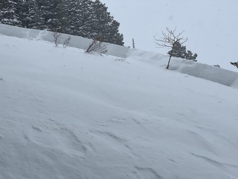
Photo from the crown of the catch and carry in Lower/Mid East facing of Mineral Fork. Party member was able to hold onto a tree. (A. Conover)

In the past 48hrs:
Ad
Avalanche Problem #1
Persistent Weak Layer
Type
Location
Likelihood
Size
Description
Dangerous avalanche conditions exist on mid and upper elevation slopes facing West through North through East where 1-3' of new storm snow, and wind-blown snow has overloaded the weak, faceted snow from January and February. Over the last few days, we have begun to see recent avalanche activity on this layer. As we continue to add more snow, and more wind these avalanches are only becoming larger, more destructive, and more deadly. Avalanches may break down 1-3' deep, possibly deeper, and propagate up to 100' wide. Either way, these avalanches are likely to be unsurvivable.
A few words of caution:
  • Signs of instability may not always be present: you may or may not see or experience shooting cracks or audible whumping.
  • Tracks on the slope offer zero signs of stability. Avalanches will take out multiple existing tracks.
  • You can trigger these avalanches from a distance or below.
  • Any fresh wind slab or new snow avalanche may step down into this older layering of weak snow.
Bottom Line: There is no outsmarting this problem - avoidance is the answer. If you're traveling on the shady side of the compass, be sure to stick to terrain that's under 30° degrees in slope steepness with nothing steep above or adjacent to you.
Avalanche Problem #2
Wind Drifted Snow
Type
Location
Likelihood
Size
Description
Over the past 24 hours, we have seen gusts up to 60 mph. With so much new snow available for transport, even a small bump in winds will begin drifting snow. Sustained high winds can deposit snow around terrain features on almost any aspect, called cross-loading. For this reason, I would expect to find slabs of wind drifted snow at all upper and mid-elevation slopes, especially along with terrain features such as ridgelines, sub ridges, and gullies.
These wind drifts will be particularly touchy at upper elevation aspects facing west through north through east, where the wind drifted snow will be sitting on top of the weak faceted snow. Any wind drifted snow or new snow avalanche triggered can step down into deeper weaker layers creating a much larger avalanche.
Today look for slopes with any signs of wind drifted snow, such as cracking, hollow noises, and pillow-shaped snow, and avoiding those slopes.
Avalanche Problem #3
New Snow
Type
Location
Likelihood
Size
Description
The Upper Cottonwoods received up to 49" of new snow! I'd expect to see the new snow instabilities beginning to settle out over the next 24 hours, but with higher than expected overall snowfall totals, new snow avalanches will likely remain sensitive in steep terrain at all elevations in all aspects this morning. Yesterday, we saw the new snow avalanches fail both within the new snow itself and at the new/old interface.
Today, you may find both fast-running sluffs and sensitive storm slabs in areas that received the most snow or in areas that also had some wind-drifting. Look for signs of new snow instabilities such as cracking, and collapsing. Triggering an avalanche that initially fails in the storm snow could easily down more deeply into the weak faceted snow.
Additional Information
Since it's so dangerous and the roads and traffic will be a mess. Please take a minute and check out Drew Hardesty's new blog on "Our Jan/Feb Drought Layer and PWL Summary of Avalanche Activity on This Layering for the Central Wasatch Range." HERE.
General Announcements
Who's up for some free avalanche training? Get a refresher, become better prepared for an upcoming avalanche class, or just boost your skills. Go to https://learn.kbyg.org/ and scroll down to Step 2 for a series of interactive online avalanche courses produced by the UAC.
This information does not apply to developed ski areas or highways where avalanche control is normally done. This forecast is from the U.S.D.A. Forest Service, which is solely responsible for its content. This forecast describes general avalanche conditions and local variations always occur.