31st Annual Backcountry Benefit - September 12th - Tickets Available Here!

Forecast for the Salt Lake Area Mountains

Nikki Champion
Issued by Nikki Champion on
Saturday morning, February 24, 2024
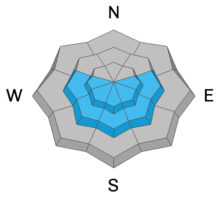
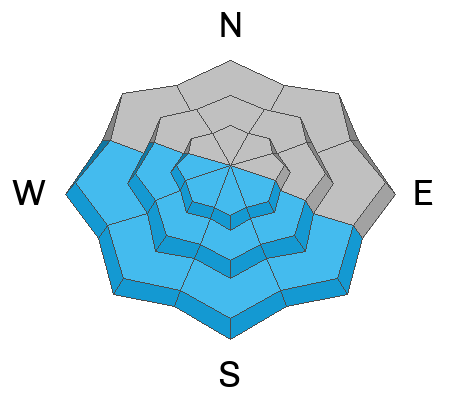
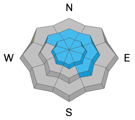
Today, the avalanche danger is MODERATE across mid and upper-elevation slopes facing east, southeast, south, southwest, and west where triggering a persistent weak layer avalanche that breaks to a crust with faceted snow 1-3 feet deep is possible. Additionally, there is a MODERATE avalanche danger across all upper-elevation terrain for both hard or soft slabs of wind-drifted snow.
On slopes facing southwest through south and southeast, the avalanche danger will rise to MODERATE as the snow surface heats up, potentially leading to small wet-loose avalanches on solar aspects. On mid and upper-elevation slopes facing southeast, any wet avalanches may trigger larger slab avalanches, failing on the persistent weak layer (PWL). The remaining aspects have a LOW avalanche danger.
It's crucial to carefully evaluate snow and terrain today, identifying potential hazards, as human-triggered avalanches are possible.
Low
Moderate
Considerable
High
Extreme
Learn how to read the forecast here
Special Announcements
Join the UAC and Inspired Summit Adventures for the grand opening of our new Transceiver Training Park at Pinebrook, Sunday, February 25, from 3:00-6:00PM.
Weather and Snow
This morning, under clear skies and nearly a full moon, there is a temperature inversion in the mountains, with trailhead temperatures in the low teens to single digits F, and ridgetop temperatures near 20 F. Winds are from the west and light through the mid-elevations, with gusts up to the mid-30s mph at 11,000 feet.
Today will be another day of strong sunshine, with temperatures warming into the upper 30s F at upper elevations and the mid-40s F at low and mid elevations. Winds will remain from the west and continue to be generally light to moderate, with gusts near 35 mph at 11,000 feet.
Outlook: The weekend remains sunny. Snow is expected to start late Monday morning or early afternoon, heaviest in areas with southwest flow. Before the cold front, snow levels will be around 6500 to 7000 feet and denser. A strong cold front will move through Monday night into Tuesday morning, bringing strong winds and heavy snow. Temperatures will drop quickly. Snowfall rates of 1 to 2 inches per hour are likely along and behind the front. Snow will continue into early Wednesday, with some models suggesting it may end before midnight Tuesday. This next storm could bring 15-25 inches of snow to the Central Cottonwoods.
Travel and riding conditions are superb, although some slopes may be crusted this morning due to the strong sunshine yesterday and some greenhousing on Thursday.
Recent Avalanches
Avalanche activity yesterday included long-running sluffs within the ski resorts and backcountry, as well as some larger avalanches failing on two different layers of buried persistent weak layers. The first was an avalanche triggered Friday morning on an east-facing flank of Superior near 10,400 feet. This avalanche was skier-triggered and failed 2 feet deep and 100 feet wide. It likely failed as a wind slab on top of the Valentine's Day crust facet interface. See the photo Below.
The second large avalanche triggered on a persistent weak layer was in Banana Days of Days Fork. This avalanche was ski-triggered on a northeast aspect near 10,200 feet. It failed 6 feet deep and 50 feet wide in steep, shallow rocky terrain and ran close to 700 feet. This avalanche appeared to fail on facets near the ground. This is a stark reminder that although the early-season persistent weak layer problem has been dropped from the daily forecast, the persistent weak layer itself is not entirely gone. Though the likelihood is so low that it no longer makes sense to include it in the daily forecast, but in steep, rocky, and suspect terrain, the small potential of triggering an avalanche within this layer still exists. Pay attention to the terrain when traveling.
Glide avalanches were also reported in Broads Fork near Blue Ice and the Diving Board.

On Thursday evening, a very large avalanche occurred on Miller Hill in American Fork Canyon. One or two people were likely caught in the avalanche. However, they were gone when the second group arrived and conducted a beacon search to ensure no one was buried. It appears that at least one snowmobile was caught and partially buried, and there was supposedly another hole where another snowmobile might have been partially buried. It's unclear if anyone was injured, but we're relieved there were no serious injuries that would have required Search and Rescue. Mark Staples visited the avalanche yesterday; it was approximately 1,500 feet wide and 2 feet deep, and it broke on a layer of faceted snow above a crust.
Ad
Avalanche Problem #1
Persistent Weak Layer
Type
Location
Likelihood
Size
Description
On certain 'solar' slopes, particularly those facing east and southeast, there is a persistent weak layer (PWL) of facets just above a crust that was buried by storms beginning February 14th. As the warm weather and clear skies persist, the likelihood of triggering an avalanche on this layer will continue to decrease, and the facets will begin to heal. However, as demonstrated by yesterday's avalanche activity and the massive avalanche on Mill Hiller on Thursday, we have not reached that point yet. Personally, I'm addressing this issue by avoiding these slopes and opting for northerly facing slopes where the snow quality is superior and this avalanche problem doesn't seem as much of an issue.

Mark discusses the avalanche problem that is primarily isolated to the East and Southeast facing aspects.

While we are beginning to consider shrinking this avalanche problem, as it appears to be primarily isolated to southeast through east-facing aspects. However, there is still a chance of encountering this layering and issue on western-facing aspects, though the likelihood is significantly lower compared to the aspects facing southeast and east.
Avalanche Problem #2
Wet Snow
Type
Location
Likelihood
Size
Description
Strong sunshine and warm temperatures will trigger wet-loose avalanches on steep, sunny slopes. On mid and upper elevation slopes facing southeast, any wet avalanches may trigger larger slab avalanches, resulting in failure on the persistent weak layer (PWL).
Wet snow is the easiest avalanche problem to avoid; simply move to shady slopes once the snow surface becomes wet. Look for signs that the snow surface is becoming wet, such as rollerballs and pinwheels. Remember, even a "small" avalanche can be deadly in consequential terrain.
Avalanche Problem #3
Wind Drifted Snow
Type
Location
Likelihood
Size
Description
With strong winds last week, stubborn slabs of wind-drifted snow are likely to be encountered on all upper-elevation slopes and some mid-elevation terrain features that allow for drifting snow accumulation. Some of these wind drifts may be reactive if they formed on top of graupel. The graupel layers vary, but they can often be found below steeper cliff bands where graupel can accumulate.
These drifts could be 1-3 feet deep and up to 150 feet wide. Watch out for signs of wind-drifted snow, such as pillow-shaped deposits, and avoid those slopes. Any recent wind drifts were covered by snowfall Wednesday night, so you will need to dig down to search for them.
General Announcements
This information does not apply to developed ski areas or highways where avalanche control is normally done. This forecast is from the U.S.D.A. Forest Service, which is solely responsible for its content. This forecast describes general avalanche conditions and local variations always occur.