Forecast for the Salt Lake Area Mountains

Evelyn Lees
Issued by Evelyn Lees for
Tuesday, January 8, 2019
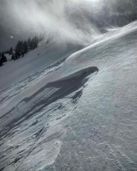
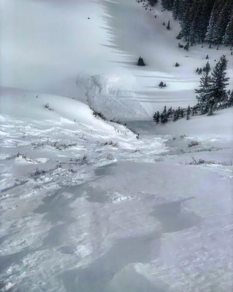
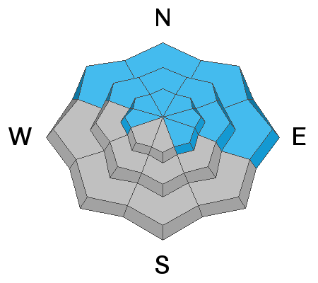
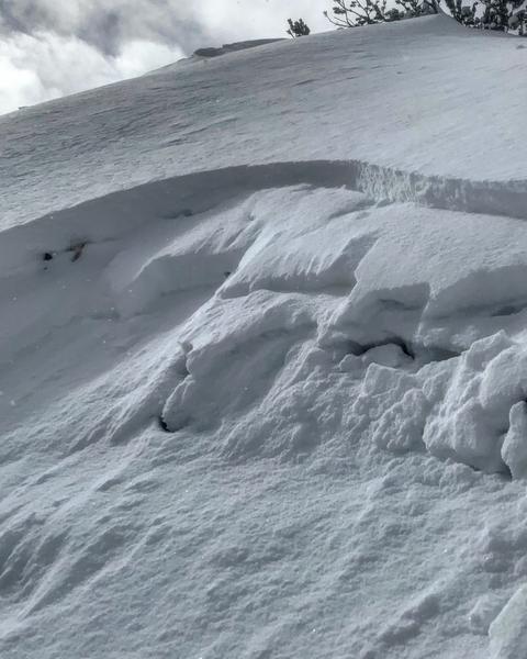
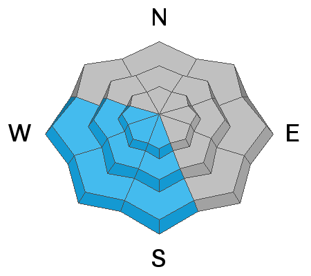
Dangerous avalanche conditions - the avalanche danger is CONSIDERABLE on all steep low, mid and upper elevation slopes for triggering slabs of wind-drifted snow, which can be found on all aspects. CONSIDERABLE means human triggered slides are likely, and natural avalanche possible. Avalanches can be triggered from a distance or below, breaking on faceted weak layers, especially on wind loaded slopes in shallow snowpack areas such as Mill Creek and the Park City ridge line. Wet loose sluffs are possible on steep, sunny slopes as temperatures warm today.
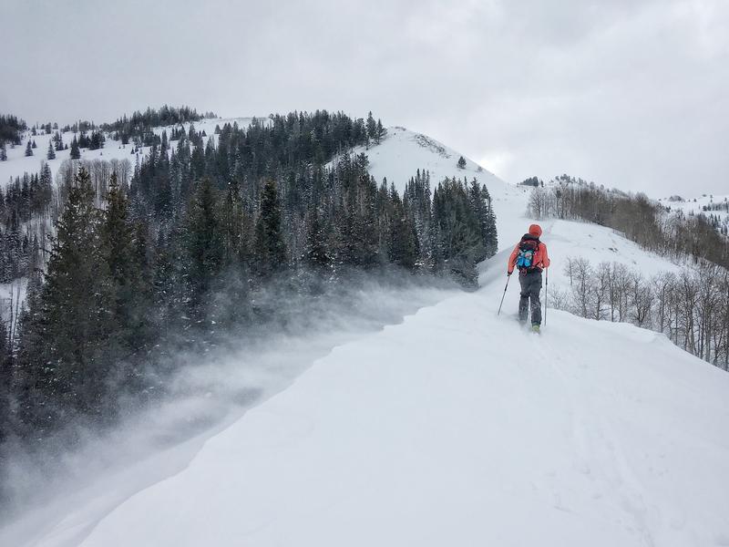
Careful snowpack evaluation, cautious route finding and conservative decision making are essential for backcountry travel today. Wind sheltered terrain is the place to go.
Low
Moderate
Considerable
High
Extreme
Learn how to read the forecast here
Weather and Snow
Whew! It’s been a wild 48 hours of snow and wind.
  • Park City side - 18 - 24 inches of snow, up to 2” of water
  • Cottonwoods - 24 to 36” of snow, 2 to 3” of water
  • Significant southwest winds on Monday: Ridgeline speeds averaging 30 to 40 mph, with gusts in 60s. 25 mph average speeds, with gusts in the 40s occurred at the mid and low elevations, too
This morning, under partly cloudy skies, temperatures are in the upper teens to mid 20s and forecast to warm dramatically into the mid 30s at 9,000’ today. Winds are from the northwest, averaging 5 to 10 mph, with the highest peaks averaging 15 - 20 mph. The snow is “upside down” - denser and wind blown snow is sitting on top of light density snow. So trail breaking is tough and turns punchy - settlement will hopefully improve conditions.
Recent Avalanches
In the backcountry, there was widespread collapsing and cracking with small test slopes releasing in the new snow. Two slides were remotely triggered on Scotts Bluff, stepping down into the facets near the ground. Naturals were observed on South Monitor and the Hanging snowfield on the Park City ridgeline. Natural and artillery released slides occured in the steep south facing paths above Little Cottonwood Canyon.
At the resorts, widespread new snow avalanches were reported, especially in wind drifted terrain. These were naturals and slides released with explosives and ski cuts. Some were stubborn, some pulled onto lower angle slopes. These slides were easily large enough to bury a person.
Ad
Avalanche Problem #1
Wind Drifted Snow
Type
Location
Likelihood
Size
Description
Yesterday’s winds were drifting snow at all elevations and on all aspects - high ridge lines, mid elevations bowls and subridges and even into the low elevations. Avoid the dense and cakey slabs of wind drifted snow on steep slopes and watch for these drifts in unusual spots at the mid and lower elevations. These drifts may be even more stubborn today, wanting to break above you. Instead, head for very wind sheltered terrain.
Photo: Fink and Slack
Avalanche Problem #2
Persistent Weak Layer
Type
Location
Likelihood
Size
Description
It has gotten more complicated - there is weak, sugary faceted snow mid snowpack and near the ground. You are most likely to trigger a slide on one of the mid-pack faceted weak layers on a wind drifted slope. Slides breaking on sugary facets can be remotely triggered from a distance or from below, and would most likely on a wind drifted slope.
Slopes with a shallow snowpack, such as slopes that have slid one or more times this year and the Mill Creek Canyon and Park City ridge line terrain, are where slides are more likely to break near the ground. Look at the photo below, and see how fast the slide broke down into the facets near the ground.
Scotts Bluff slides: Mark White photo
Avalanche Problem #3
Wet Snow
Type
Location
Likelihood
Size
Description
Today’s wild card - much warmer temperatures and the possibility of direct sun are in today’s forecast. This combination may heat the snow surface on steep sunny slopes, and wet loose sluffs will become possible. Look for telltale signs of heating snow - the snow becoming heavy, damp or sticky, roller balls or small wet loose sluffs starting to run. This means it’s time to get off of and out from under the steep sunny slopes that are heating.
Additional Information
Ice climbers: Sizable sluffs are still likely to run on the north facing ice climbs in Little Cottonwood Canyon and Provo Canyon. Many of the Wasatch ice climbs are in avalanche run outs - be aware of what terrain is above you.
General Announcements
This information does not apply to developed ski areas or highways where avalanche control is normally done. This forecast is from the U.S.D.A. Forest Service, which is solely responsible for its content. This forecast describes general avalanche conditions and local variations always occur.