Sign Up for the Utah Snow and Avalanche Workshop (USAW) on December 7th!

Forecast for the Salt Lake Area Mountains

Drew Hardesty
Issued by Drew Hardesty on
Monday morning, January 29, 2024
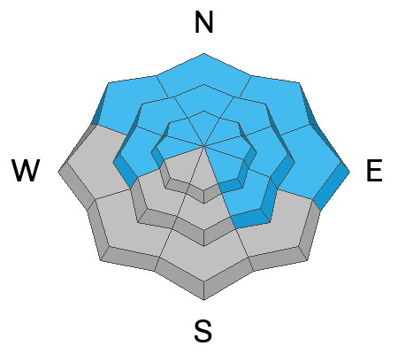
  • A MODERATE DANGER exists on steep west to north to southeast facing slopes for triggering a 2-5' thick hard slab avalanche that fails on a persistent weak layer. Human triggered avalanches are possible and more likely in steep, thin, rocky terrain.
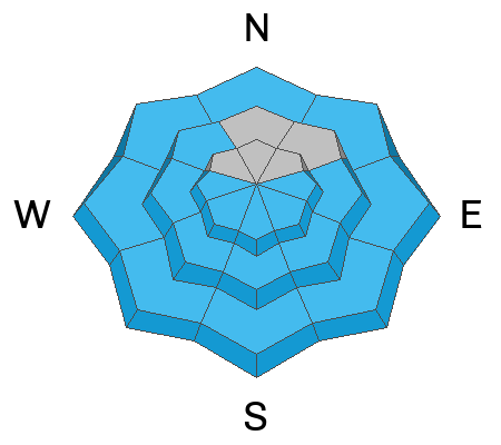
  • With clear skies and skyrocketing temps, the danger for wet avalanches will rise to MODERATE and possibly CONSIDERABLE on all steep sunny (as well as low elevation shady) slopes. Don't overstay your welcome in the oven.
  • Last, don't be surprised to trigger new but shallow soft slabs of wind drifted snow in the highest elevations today.
Low
Moderate
Considerable
High
Extreme
Learn how to read the forecast here
Special Announcements
Join us for a Motorized Backcountry 101: Introduction to Avalanches class on February 2-3 down on the Skyline. Click HERE for more information.
Weather and Snow
Skies are clear.
Mountain temperatures are in the upper 20s to mid-30s.
Winds are light from the northwest except along the highest elevations where hourly averages are 25-30mph with gusts to 50.
The ridge of high pressure moves squarely overhead today and we'll have clear skies and diminishing winds. Mountain temperatures will skyrocket again to near 40°F along the ridgelines and perhaps 50°F at the base areas and trailheads. Temperatures will be even warmer Tuesday as the ridge moves to the east and we back to a southwest flow (winds now from the southwest) ahead of a storm later in this week (Thursday eve).
Riding conditions remain excellent in the sun and wind sheltered terrain. Solar aspects and low elevation northerlies have a crust that will soften with daytime warming. Developing surface hoar may be noted in sheltered terrain.

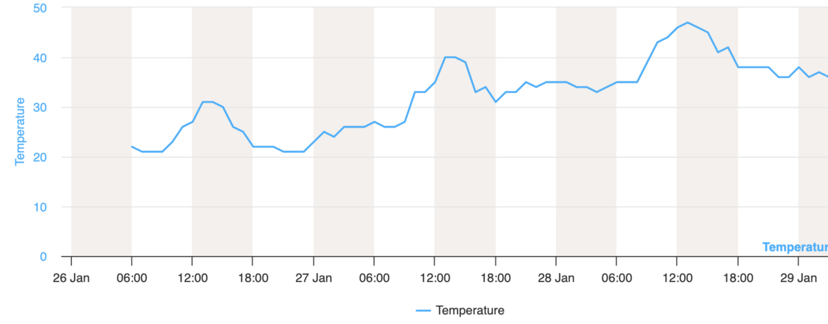
The January thaw: Note the increasing highs and lows the last couple of days: This is the Mill D North station in BCC at 8900'. It's in what I call the "thermal belt": not as cold as the highest elevations and not subject to cold air pooling down low in the basins and drainages. While Mill D North has a 5am temp of 35°F, clear skies and radiational cooling will still allow for a decent refreeze.
Recent Avalanches
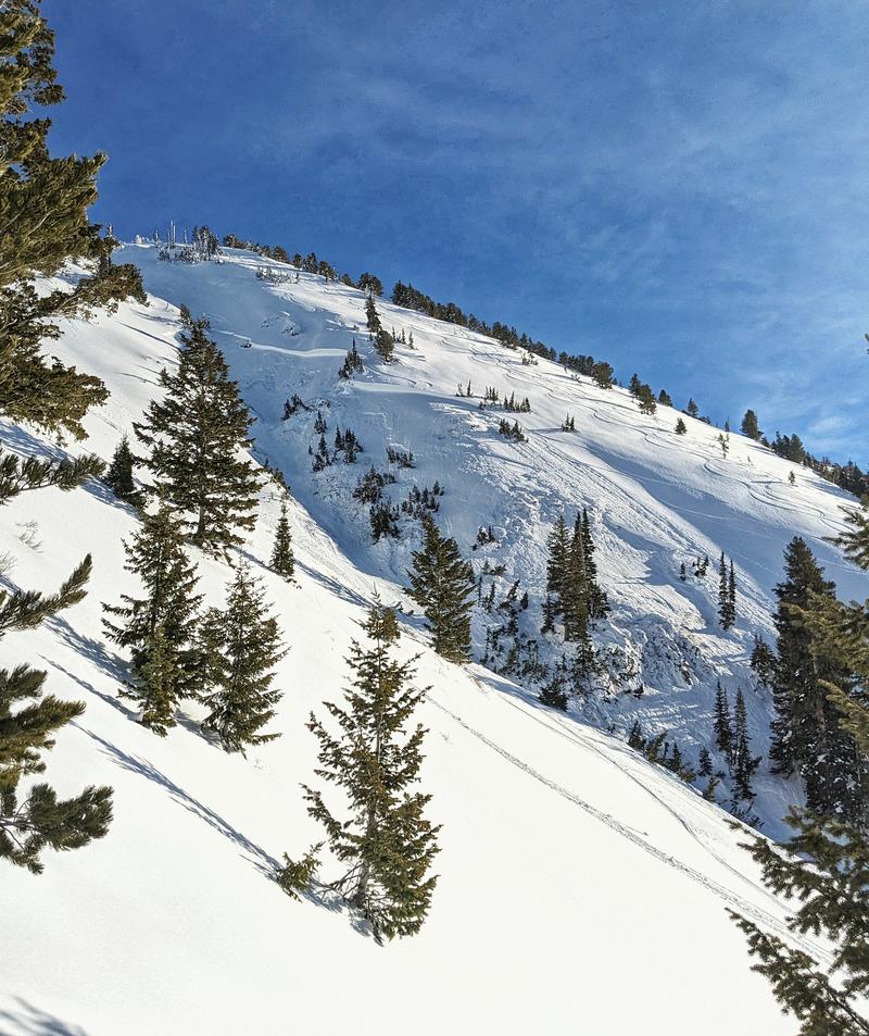
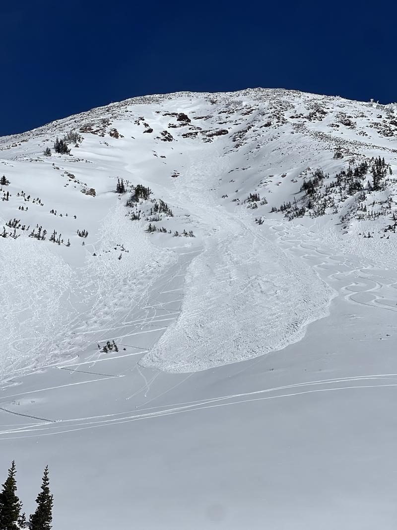
Yesterday on Gobblers Knob, the third skier in Davis Gulch triggered a 2-4'+ deep hard slab that failed on our December PWL of weak faceted snow. He was caught and carried but ok. This was on a steep northwest facing slope at 9800' and the POV footage is some of the more breathtaking footage I've ever seen. Thanks to the party for the footage and write-up. (photo S. Donovan)
Davis Gulch was named after Alan Davis. who was killed on this same slope mid-February 2003.


With skyrocketing temps yesterday, many wet loose and a few wet slab avalanches barreled down steep solar terrain as they became wet and unstable. See more info below.

Click here for all recent observations and avalanches.
Ad
Avalanche Problem #1
Persistent Weak Layer
Type
Location
Likelihood
Size
Description
Our PWL (persistent weak layer) of facets from the December drought is generally buried 2-5' deep and is easy to find by digging down with your shovel on west to north to southeast facing slopes. It is becoming more difficult to trigger this unstable combination in deeper snowpack areas, particularly in the upper Cottonwoods. Full avalanche mitigation efforts to open previously closed ski area terrain yesterday in upper LCC produced no results. Tests and observations like this one in White Pine of LCC on northwest facing terrain hint at a stabilizing snowpack.
So what to make of the Davis Gulch avalanche? There are some similarities to the remotely triggered avalanche in East Bowl of Silver Fork from Wednesday the 24th. The predominant northwesterly winds have stripped and eroded many northwest facing slopes, making the slab thinner, the facets probably weaker and therefore more susceptible to triggering. My best guess is that the skier caught and carried (mind you, she was the third skier), found a thinner spot on the slab that triggered the avalanche where it then propagated into much more wind loaded terrain. The photo above shows this well. It was a close call.

Bottom Line: it takes a LOT of homework - knowing slope history, knowing wind patterns, knowing which drainages have poor vs good structure, doing lots of probing and digging of snowpits and sharing of information to be able to ride steep terrain. And even then you may not get away with it. Human triggered avalanches are possible? No thanks.
Avalanche Problem #2
Wet Snow
Type
Location
Likelihood
Size
Description
With clear skies and warmer overnight temperatures, wet avalanches will start to run earlier today than yesterday, starting on east then south then west and eventually some northwest facing slopes. In steep, sustained and confined terrain, some of these wet avalanches will run fast and far and easily lead to significant debris piles. We had lots of reports of long running destructive avalanches in Tanners, the White Pine Chutes, Superior, even the Comma Chutes (NW facing) above the Bypass road in LCC etc etc. One wet avalanche took out a skin track in west facing White Pine (Tri-Chutes?) (Nick McEachern photo below). In some areas, much more destructive wet slab avalanches may occur, from either being pried out by wet loose sluffs from above, or - in some cases - melt water percolating down to structural interfaces (density changes and/or facets and crusts).
Travel advice: If you see pinwheels and rollerballs and are finding the snow start to become unsupportable, move on to low angle terrain or cooler aspects.


Though not technically wet avalanches per se, GLIDE AVALANCHES may start to release in the usual terrain of Stairs, Broads, Mill B South of BCC and the north side of Raymond in MCC. Probably best to avoid this terrain for awhile until it cools off...and even then give it a few days.
General Announcements
This information does not apply to developed ski areas or highways where avalanche control is normally done. This forecast is from the U.S.D.A. Forest Service, which is solely responsible for its content. This forecast describes general avalanche conditions and local variations always occur.