Donate to Our Spring Campaign or Bid on our Spring Auction to Support Forecasting

Forecast for the Provo Area Mountains

Paige Pagnucco
Issued by Paige Pagnucco on
Wednesday morning, March 12, 2025
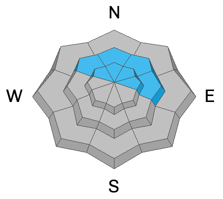
The avalanche danger is MODERATE on upper and mid-elevation steep slopes where human-triggered avalanches of wind-drifted snow are possible, especially along lee ridgelines and in and around terrain features like scoops and gullies. These are especially concerning in northerly-facing terrain where older, faceted snow is buried 1 to 4 feet deep. The danger of loose wet avalanches is becoming less of a concern, but they are still possible with daytime heating.
Evaluate snow and terrain carefully today.

In the Provo Region, wet snow avalanches can run long distances, sometimes reaching below the snow line and crossing summer hiking trails. This means that even those not traveling in avalanche terrain could be caught in a late-afternoon wet slide descending from above.
Low
Moderate
Considerable
High
Extreme
Learn how to read the forecast here
Special Announcements
We are heartbroken to confirm that 51-year-old Micheal Janulaitis of Marion, Utah, was killed in an avalanche on March 7 near Hoyt Peak. Micheal was caught and carried while skiing a steep, northeast-facing run in Hoyt Bowl. We are deeply grateful to the teams who helped bring him home. Micheal was a friend of the UAC, and his loss is felt deeply in the backcountry community. He will be greatly missed.
We are compiling accident details and a preliminary report can be found HERE.
March kicks off our Spring Campaign! If everyone in Utah’s backcountry community donates the cost of something they regularly enjoy on an adventure—like a dawn patrol burrito, a backpack snack, or post-ride trailhead drinks—we could fund not just one but two forecasters for the entire season! Donate here. Thank you!
Weather and Snow
This morning, temperatures are in the mid-20s to low 30s °F. Winds are southwesterly, blowing in the teens mph, with gusts near 30 mph, and even higher along the highest ridgelines.
Today is the last day of false spring #1. The 8500' high will be near 45°F and we'll have mostly sunny skies. Winds will pick up in the afternoon blowing 15 to 25 mph with gusts near 40 mph from the south-southwest.
Outlook: Snow will begin falling in earnest tomorrow morning with the heaviest snow anticipated Thursday afternoon and evening with the passage of the cold front, causing a rapid fall in snow levels. Snow will continue
into Friday morning before diminishing. Forecast storm totals are about 8-15" of new snow by Friday morning. Gradual cooling should create right-side-up conditions.
Snow Conditions: Very variable. A mix of wind crusts, melt-freeze crusts, some breakable, some not. Pockets of soft snow exist in N-facing terrain at mid and upper elevations. Everything else has been zapped by the sun.
Recent Avalanches
Wet loose activity has diminished over the past day or two, but there is ample visual evidence of warmth-driven activity throughout the region. Drew visited the Provo region yesterday and wrote a great observation. Read it here.

Check out all avalanches and observations HERE.
Ad
Avalanche Problem #1
Wind Drifted Snow
Type
Location
Likelihood
Size
Description
Yesterday, we observed wind moving snow in all directions. Slopes were getting top-loaded, cross-loaded, and up-loaded in the most exposed terrain. With consistent strong winds forecast for today, expect to see slabs of wind-drifted snow forming near lee ridgelines and in and around terrain features like gullies, scoops, and rollovers. These may offer no signs of instability like cracking and could release once you are well out onto them.
Watch for and avoid signs of wind-drifted snow, such as textured or pillow-shaped features. Approach steep terrain cautiously, especially where drifting snow has accumulated.
Obvious signs of wind-drifted snow include texture, pillow-shaped features, and cracking like seen below. (MW)
Avalanche Problem #2
Persistent Weak Layer
Type
Location
Likelihood
Size
Description
The Provo area has held weak snow all season, and none of us really trust the snowpack there. Buried faceted snow is still a major problem, as we are still getting propagation in stability tests. Drew's video offers a great description of the problem (see above). The only way to avoid this problem is to avoid steep slopes with this poor snow structure.
Avalanche Problem #3
Wet Snow
Type
Location
Likelihood
Size
Description
We are past the peak wet snow instability but, with continued warm daytime temps and a poor overnight refreeze, wet snow avalanches are still possible today. Any slope baked by the warm sun is suspect. When the snow starts feeling mushy and you are sinking in past your ankles, it is time to move to a cooler aspect or elevation or lower-angle terrain. The strong winds may help minimize this problem today.
General Announcements
This information does not apply to developed ski areas or highways where avalanche control is normally done. This forecast is from the U.S.D.A. Forest Service, which is solely responsible for its content. This forecast describes general avalanche conditions and local variations always occur.