UDOT PLANNED AVALANCHE CLOSURES!!

Forecast for the Provo Area Mountains

Greg Gagne
Issued by Greg Gagne for
Friday, April 19, 2019
With strong sunshine and warm temperatures, the hazard for wet avalanches may rise to Considerable on aspects facing southeast through west, with a Moderate hazard elsewhere. Activity may involve both loose sluffs as well as larger, wet slab avalanches. Wet avalanche activity will begin much earlier than the past two days, possibly by mid-morning.
Mark will update the Salt Lake City, Ogden and Provo forecasts Saturday morning (April 20th) by 7:30 am.
Low
Moderate
Considerable
High
Extreme
Learn how to read the forecast here
Special Announcements
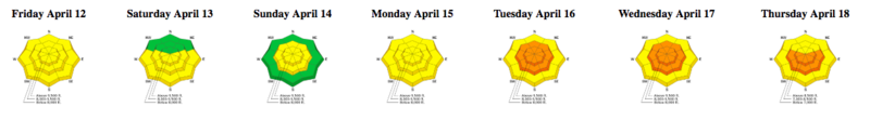
The last scheduled forecast will be Sunday, April 21st. We will issue intermittent updates with each snowfall or significant weather event through the rest of the month. We will continue posting observations - so please continue to send those in!

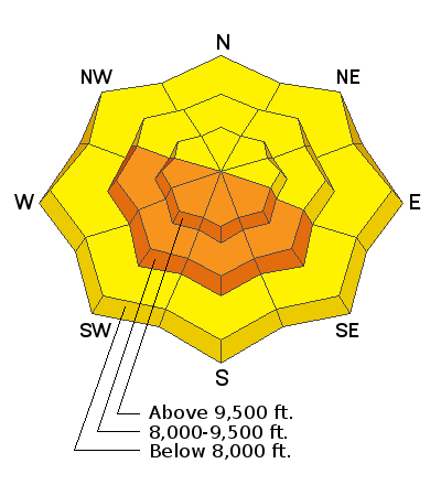
Resorts closed for the season are now backcountry terrain - no avalanche mitigation is being done. Utah ski resorts are on a mix of private and public Forest Service land, and each resort has a different uphill policy - contact the individual resort for details.
Weather and Snow
Temperatures this morning in the Provo mountains are in the 40's F - with above-freezing temperatures even at 11,000' - and are +4 to +12 degrees warmer than they were yesterday morning. (Click on this link to see the temperatures at Collins station in Little Cottonwood.)
Wind are blowing from the west and northwest averaging < 10 mph, with gusts in the teens and 20's mph along upper elevation ridges.
Today's weather features strong sunshine where mountain temperatures will climb well into the 40s F and 50s F, perhaps even pushing 60 F at 8000'. Winds will shift to the southwest and be generally light, gusting into the teens and low 20's mph along upper elevation ridgelines.
Although mountain temperatures are above freezing this morning, the clear skies should provide a marginal refreeze of the snow surface, but it should soften very quickly after sunrise.
Our final Week in Review for the 2018/19 season is available. Thanks for all the feedback on this weekly product we provide, and we look forward to resuming it in November!
Recent Avalanches
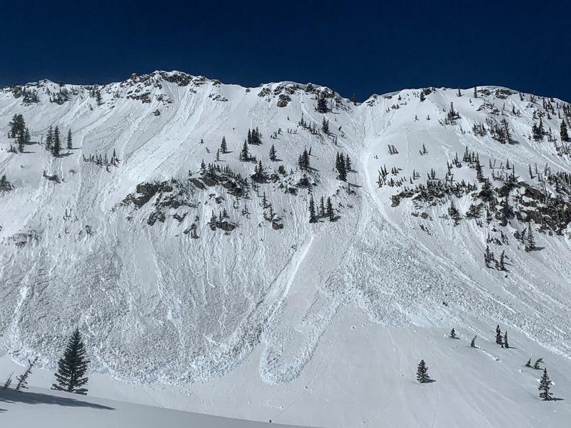
Beginning by late morning Thursday, loose wet avalanches began to occur, including larger slides on Mt. Superior and East Hellgate cliffs in Little Cottonwood Canyon. Pro observer Mark White and Erme Catino were in Red Pine Gulch, and noted wet avalanches beginning around noon on east aspects [photo Mark White]
Mitigation work at some Cottonwood resorts pried out a few soft slab avalanches in dry snow on upper elevation northerly aspects. In Mary Ellen Gulch, evidence of both wet and dry avalanche activity [photo Zimmerman-Wall]
Ad
Avalanche Problem #1
Wet Snow
Type
Location
Likelihood
Size
Description
After two days of strong sunshine and warm temperatures, I think we have gone through much of the wet avalanche cycle that shed the snowfall from earlier this week. But the (1) lack of an overnight refreeze with overnight "lows" +4 to +12 warmer than 24 hours earlier and (2) temperatures that are forecasted to be much warmer than Thursday maintain the risk of wet avalanches today. The past two days wet avalanche activity began by late morning, but I am expecting things to become active much earlier today, including both wet sluffing and possibly much larger wet slabs. The only terrain that may be spared from wet avalanche activity today are northerly aspects above about 9,000'.
Timing is everything! It's time to move off of the snow once the surface becomes soft, wet, and unsupportable.
Additional Information
For those that want to delve a little deeper into the issues of avalanches involving wet snow: A couple of observations from this week highlight the structure of the snowpack where crusts may inhibit the flow of liquid water as it moves down through the snowpack, creating the possibility for larger, wet slab avalanches. On Tuesday I was finding a layered snowpack in East Bowl of Mineral Fork (observation), and on Thursday Sean Zimmerman-Wall (with a few other colleagues) submitted a very nice observation from Mary Ellen Gulch (observation) where his party noted several different crusts in the upper meter of the snowpack. (Quoting from Sean's observation "The presence of multiple crusts in upper meter of the snow pack provides locations for free water to pool and potentially release wet slab avalanches 30 to 85cm deep").
General Announcements
This information does not apply to developed ski areas or highways where avalanche control is normally done. This forecast is from the U.S.D.A. Forest Service, which is solely responsible for its content. This forecast describes general avalanche conditions and local variations always occur.