Forecast for the Provo Area Mountains

Mark Staples
Issued by Mark Staples for
Saturday, April 13, 2019
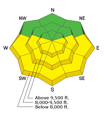
The main avalanche problem today will be wet snow avalanches as strong sunshine heats up new snow from this week making the avalanche danger MODERATE.

Better stability and better riding conditions will be found on northerly aspects where dry snow should remain through the day and the danger is LOW. However, recent avalanche activity in the new snow tells us that a small chance remains for dry snow avalanches. These instabilities are most likely lingering on slopes with wind drifted snow.
Low
Moderate
Considerable
High
Extreme
Learn how to read the forecast here
Special Announcements
Daily early morning avalanche forecasts will end tomorrow, Sunday, April 14. We will issue early morning forecasts on Friday, Saturday, and Sunday of Easter weekend (April 19-21). Throughout the rest of April, we will issue intermittent updates with any snowfall or other significant weather events, and we will continue posting observations.

Drew Hardesty just penned another wonderful blog piece, Meditations on Skiing the No-Fall Zone.
Our final podcast for the season has been released HERE. Low Danger - A Story in 5 Parts. Thanks much to our producer Benjamin Bombard and our sponsors Arva, Prival, and 2nd Tracks Sports.
Weather and Snow
Yesterday: Cloudy skies and snow showers kept things from heating up too much. High temperatures were mostly in the mid to upper 30s F. Winds were light. Snow showers produced a trace of new snow.
This morning: Mostly clear skies allowed temperatures to drop into the low to mid 20s F. Westerly winds this morning are averaging 7-10 mph with gusts up to 18 mph.
Today: Clouds should dissipate this morning and there should be more and more sunshine appearing through the day. Temperatures should warm more than yesterday and easily climb into the mid and upper 40s F depending on elevation. A brief ridge of high pressure will build today, but a series of storms is headed our way starting tomorrow with strong southwest winds.
Recent Avalanches
There have been a few avalanches within the new snow reported further north near Salt Lake where more snow fell this week. All of these slides appear to be breaking within the new snow where slightly denser snow is resting on softer snow. Similar slides seem possible at the highest elevations in the Provo around mountains. One small avalanche occurred on Mill Canyon Peak in American Fork Canyon.

If heading to the Salt Lake area mountains or the upper reaches of American Fork Canyon behind the ski resorts, be sure to read our Week in Review.
Ad
Avalanche Problem #1
Wet Snow
Type
Location
Likelihood
Size
Description
Skies should clear today and allow strong sunshine to quickly warm the new snow. As this happens wet loose avalanches should occur. The best strategy will be to move to slopes at mid and upper elevations facing northerly where better riding conditions will be found as well.
Avalanche Problem #2
Wind Drifted Snow
Type
Location
Likelihood
Size
Description
The new snow that fell this week is generally well bonded and stable. I think today any remaining instabilities in the new snow will be in isolated spots with wind drifted snow where avalanches could break 6-12 inches deep.
Additional Information
Spring is here and it is time to adjust our travel. Learn what to watch for during spring avalanche conditions when the snow becomes wet.
General Announcements
This information does not apply to developed ski areas or highways where avalanche control is normally done. This forecast is from the U.S.D.A. Forest Service, which is solely responsible for its content. This forecast describes general avalanche conditions and local variations always occur.