Forecast for the Provo Area Mountains

Trent Meisenheimer
Issued by Trent Meisenheimer for
Saturday, February 25, 2023
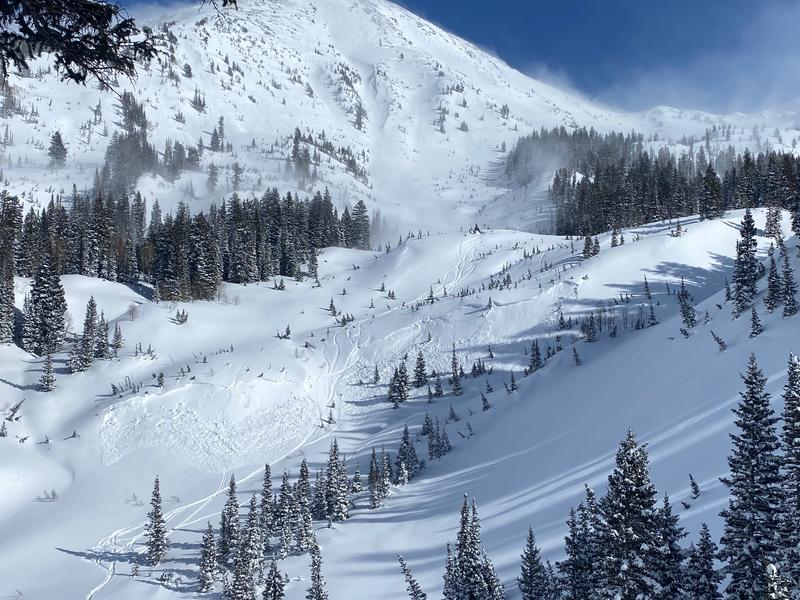
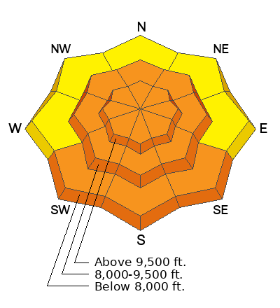
The avalanche danger is CONSIDERABLE across all mid and upper-elevation steep slopes for wind-drifted snow avalanches (wind slabs). These avalanches are likely to be triggered by a human and will be 1-2 feet deep and up to 200 feet wide, and are large enough to catch, carry, bury, and kill a person.
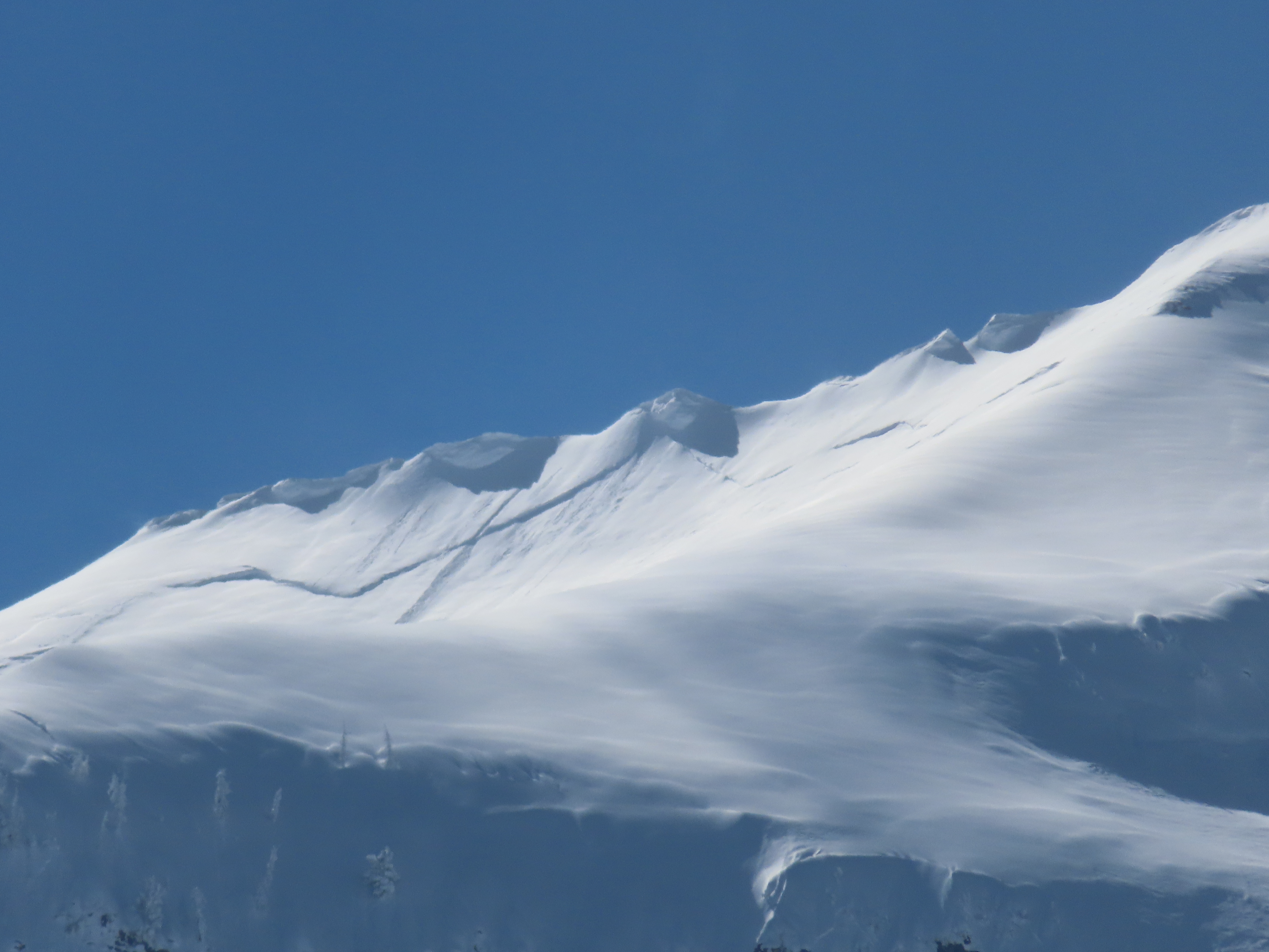
Ice climbers: Avalanches can happen naturally and run long distances today from the starting zones above many of the popular ice climbs in Provo Canyon. Today is a good day to avoid climbing in areas where avalanches can run down on top of you.

Wet-loose avalanches are likely on all southerly aspects if today's warming temperatures and strong sunshine cause the snow to become damp, wet, and therefore unstable.
Low
Moderate
Considerable
High
Extreme
Learn how to read the forecast here
Weather and Snow
Under partly cloudy skies, the mountain temperatures range from 15-23 °F. Winds started blowing from the southwest yesterday morning and continue to blow at 15-25 mph, gusting into the 30s & 40s across most of the upper-elevation terrain.
This morning we expect mostly clear skies, with mountain temperatures rising into the mid-thirties °F this afternoon. The southwest winds will peak this morning and then decrease throughout the day. Sky cover is forecast to be clear to partly cloudy in the morning, with increasing clouds and filtered sunshine later in the day. Beginning Sunday, we will see the start of a multi-day storm that will once again bring feet of snow to the mountains. More to come.

Storm totals since Tuesday (snow/water)
Cottonwoods 34-45"/2.5-3.0"
Park City Ridgeline 36"/2.3"
Ogden 39"/3.4"
Provo 36-49"/3.3-3.82"
Recent Avalanches
From the foothills to the peaks. Since yesterday there have been 20 avalanches reported to the UAC. Most of these avalanches are from the southerly winds whipping our new snow into slabs. These wind-drifted snow avalanches occurred at elevations between 6,200' in the foothills to 10,000' starting zones, and they happened on all aspects and are generally 1-2 feet deep and up to 200 feet wide. Be sure to check out the avalanches and observations tab HERE.
Photo: UDOT Provo, Avalanche cycle this past week in the Provo Mountains.
Ad
Avalanche Problem #1
Wind Drifted Snow
Type
Location
Likelihood
Size
Description
Southerly winds have been blowing strong at 15-35 mph averages across many aspects and elevations for the past 24 hrs. This morning these winds continue to blow from the southwest at similar speeds. As a result, it's taken this week's new snow and whipped it into dense slabs of wind-drifted snow.
Recent avalanches should be enough to convince us that the snow is unstable, and we should be on guard today with cautious route-finding and conservative decision-making. Human-triggered avalanches are likely, and I fear someone will get buried today with the lure of powder and plenty of sunshine.
Photo: Torry. White Pine (LCC) showing wind slab avalanches on a steep mid-slope breakover.
Avalanche Problem #2
Wet Snow
Type
Location
Likelihood
Size
Description
This avalanche problem will be the wild card today. Temperatures are forecast to rise into the mid and upper 30s °F this afternoon at about 8,800 feet. Clear skies and late February sunshine could be enough to cause a wet loose avalanche cycle today, especially at the low and mid-elevations.
Wind could be the saving grace for the upper elevation slopes where the snow is very dense (wind slabs) and will be kept colder from the southerly winds. Look for roller balls on any southerly aspect and watch for the surface snow becoming damp and wet. If that happens, I would either head home or switch to a colder aspect.
General Announcements
This information does not apply to developed ski areas or highways where avalanche control is normally done. This forecast is from the U.S.D.A. Forest Service, which is solely responsible for its content. This forecast describes general avalanche conditions and local variations always occur.