Forecast for the Provo Area Mountains

Trent Meisenheimer
Issued by Trent Meisenheimer on
Monday morning, February 17, 2025
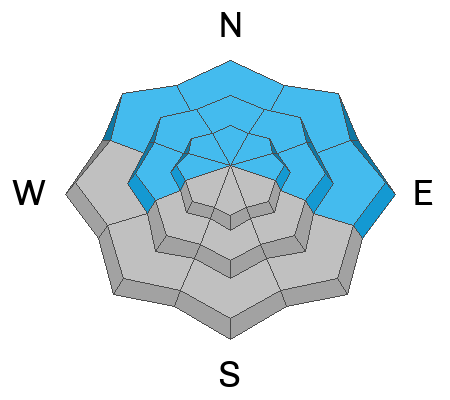
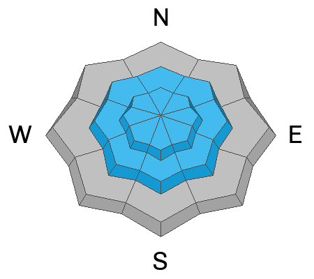
The avalanche danger is HIGH on mid and upper-elevation slopes, where it is very likely that you will trigger an avalanche failing on one of many buried weak layers within the snowpack. These avalanches will be deep enough to bury, injure, or kill a person. Traveling in avalanche terrain is NOT recommended.
Low
Moderate
Considerable
High
Extreme
Learn how to read the forecast here
Weather and Snow
Within the past 24 hours, we've picked up another 4-6 inches of new snow (0.40-0.48 inches of water). Since Friday, we've seen 22-30 inches of new snow (3.50-5.00 inches of water). Current mountain temperatures range from 23-30 °F. Across upper-elevation terrain, the wind is blowing from the northwest, averaging 10-15 mph with gusts close to 30 mph. The free air (11,000') is moving faster with speeds of 30-40 mph.
Today, the flow will continue to be from the west and northwest where we will see periods of snowfall throughout the day. This could bring an additional 2-7 inches of new snow by this evening. Temperatures will climb into the upper 20s °F.
Recent Avalanches
Many avalanches were reported from the Central Wasatch. Yesterday, I was in the Provo zone and was not able to see any of the avalanche terrain due to snowfall. I did dig a pit on a north-facing slope at 8,000 feet and got ECTP 22 video below:
Ad
Avalanche Problem #1
Persistent Weak Layer
Type
Location
Likelihood
Size
Description
Our snowpack is a junk show! It's time to back off. Three weak layers are now buried in the snowpack.
1. November / December faceted snow near the ground.
2. Slopes that previously avalanched (repeaters).
3. Late January faceted snow.
Avalanches can break on a variety of layers, and it's hard to determine which layer they will fail on. In any case, avalanches are large enough to bury, injure, or kill a person. The travel advice is simple: Traveling in avalanche terrain is NOT recommended.
Avalanche Problem #2
Wind Drifted Snow
Type
Location
Likelihood
Size
Description
Strong winds have and will continue to create sensitive wind drifts on all aspects at the mid and upper-elevations. Cornices have grown large and may break further from ridgelines than expected. Any avalanche involving wind-drifted snow may step down to a buried persistent weak layer. Traveling in avalanche terrain is NOT recommended
Avalanche Problem #3
New Snow
Type
Location
Likelihood
Size
Description
It continues to snow, and as it does, we can expect to see avalanches fail in density changes within the new snow or at the old/new snow interface that in some cases has faceted snow in play. Dry-loose avalanches will also be on the rise as the storm gets colder throughout the day. Traveling in avalanche terrain is NOT recommended.
Additional Information
I was talking with Jonathan Morgan (Alta Avalanche Office) on the phone last night and we were trying to remember a year as complicated as this year with all the variability across the terrain. I mean, think about it. Normally, it's pretty simple and we have just one weak layer in the snowpack on a couple of aspects. Not this year. We have multiple weak layers all over the place on many different aspects and elevations. Oh, and don't forget the slopes that already avalanched. We have multiple avalanche problems outside of persistent weak layers, all with issues where they can break on various layers. I've been in the SLC office since 2015, and I can't remember a time that was this complicated. The last year I can think of where it was this bad was the winter of 2004/2005, when we had a really bad snowpack, and we saw eight fatalities that season. We've had four people tragically die already this year. Please do not try to outsmart the snowpack. Please keep it simple and avoid steep terrain.
General Announcements
This information does not apply to developed ski areas or highways where avalanche control is normally done. This forecast is from the U.S.D.A. Forest Service, which is solely responsible for its content. This forecast describes general avalanche conditions and local variations always occur.