Forecast for the Provo Area Mountains

Mark Staples
Issued by Mark Staples for
Wednesday, February 1, 2023
The avalanche danger is MODERATE at mid and upper elevations on south and west aspects where soft slab avalanches may break on a layer of facets near an ice crust buried about 2 feet deep.
The danger is LOW on all other slopes where this layer doesn't exist, but continue to look for slabs of wind drifted snow which may still produce an avalanche today.
Low
Moderate
Considerable
High
Extreme
Learn how to read the forecast here
Weather and Snow
This morning under clear skies temperatures are in the low teens F at all elevations, about 15 degrees warmer than yesterday morning. Winds are barely blowing, but on high peaks near 11,000', winds are blowing 25 mph from the northwest.
Today, winds will continue blowing from the northwest as they are this morning. With clear skies and strong sunshine, temperatures will quickly rise into the 20s F.
Looking ahead, temperatures will continue to warm through the rest of the week with clear, sunny weather. Another storm may arrive Sunday/Monday.

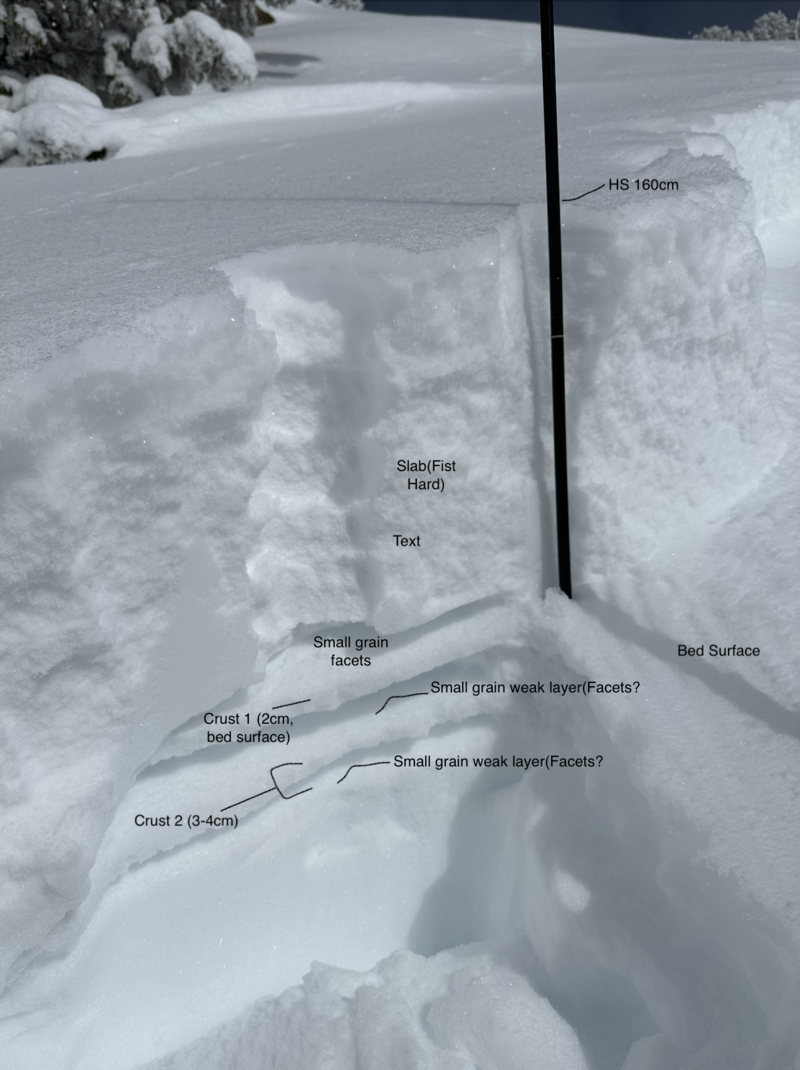
Yesterday, sunny slopes received enough sunshine and warming and they should have an ice crust on them this morning which will soften as temperatures warm this morning. Most northerly and east facing slopes have fantastic powder.
Recent Avalanches
Over the weekend, there were many wind loaded slopes that produced natural and human-triggered avalanches. What stands out are the slides that broke on a layer of very small facets next to an ice crust buried 2-3 feet deep. Some were several hundred feet wide like one in upper Little Cottonwood Canyon that happened on Sunday. These slides have mostly occurred on sunny slopes (southeast, south, southwest, and west facing) like one that was spotted yesterday in Big Cottonwood Canyon on a southeast facing slope at 9500 ft.
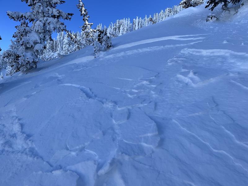
Ski guides intentionally triggered one yesterday near on Shingle Mill Peak (photo below) on a southeast facing slope near 10,000 feet. UDOT forecasters spotted two recent avalanches on southeast facing slopes on the southern end of Timpanogos and triggered two large collapses.

See the full list of avalanche activity HERE and you can filter slides by region and date.
Ad
Avalanche Problem #1
Persistent Weak Layer
Type
Location
Likelihood
Size
Description
As described above, a layer of very small facets next to an ice crust has been producing slab avalanches. If the issue was solely the new snow, then this problem would have stabilized by now. Unfortunately this layer will continue to be a concern, but it shouldn't last nearly as long as other persistent weak layers. A process currently occurring again on the snow surface (described in this video) likely formed this layer early last week during cold temperatures and brief moment of clear weather.
Here's the good news - This layer mostly exists on slopes that should have an ice crust on the surface this morning, and those are ones you will likely avoid anyway. Northerly facing slopes seem to lack this layer and will have better snow.
Photo of this layer from an avalanche on a southwest facing slope in Little Cottonwood Canyon (photo - Little).
Avalanche Problem #2
Wind Drifted Snow
Type
Location
Likelihood
Size
Description
Winds have mostly been light over the last few days except at the highest elevations. They blew from the west and northwest and formed slabs of wind drifted snow over last weekend that many people triggered. Today, these many of these winds slabs should have stabilized, but I would still look for and avoid them. A group on the Cold Fusion couloir on Mt Timpanogos yesterday triggered many small wind slabs.
Photo- Mike M.
General Announcements
This information does not apply to developed ski areas or highways where avalanche control is normally done. This forecast is from the U.S.D.A. Forest Service, which is solely responsible for its content. This forecast describes general avalanche conditions and local variations always occur.