Forecast for the Provo Area Mountains

Mark Staples
Issued by Mark Staples for
Saturday, December 9, 2023
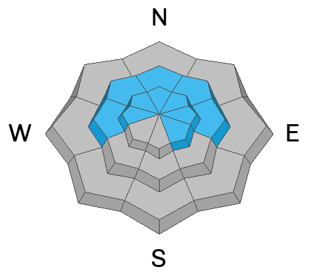
Today the avalanche danger is MODERATE at mid and upper elevations. On most aspects at these elevations, there is a persistent weak layer that could fracture and produce a big avalanche.
The danger is MODERATE on south facing slopes where new snow may sluff or produce shallow soft slabs.
Low elevations have a LOW danger and avalanches are unlikely.
Low
Moderate
Considerable
High
Extreme
Learn how to read the forecast here
Weather and Snow
Sadly the mountains near Provo were denied the snow that fell further north. Only 4 inches of snow (0.3" of water) fell yesterday. Total snow depths range from 15 to 30 inches; however, I suspect higher elevations may have closer to 40 inches of snow.

This morning it's cold with temperatures hovering around 10 deg F. Fortunately winds from the NW are generally light, averaging 4-8 mph with gusts up to 10 mph. Winds blew much stronger yesterday morning from the WNW averaging 10-20 mph, gusting 35. Winds at 11,000 ft averaged 40 mph with gust to 60 mph.
Today will be sunny with temperatures only rising to about 15 degrees F, and fortunately, winds will remain light.
Recent Avalanches
Many avalanches occurred after last weekend's major storm, many were very large. What's interesting that they happened on both east and west facing slopes. They area all listed HERE.
Ad
Avalanche Problem #1
Persistent Weak Layer
Type
Location
Likelihood
Size
Description
There is a persistent weak layer of old, weak, and faceted snow from November near the ground. It has a thick slab on top of if from last weekend's major storm plus just a few inches from yesterday's storm. Avalanches on this layer will be deep and break over huge areas.
Without major loading yesterday, avalanches on this layer will be difficult to trigger today, and many slopes already avalanches and haven't refilled with much snow.
Avalanche Problem #2
New Snow
Type
Location
Likelihood
Size
Description
Four inches of new snow may sluff today on the old snow surface and you may find a few places where yesterday morning's strong winds formed shallow slabs that could release.
General Announcements
This information does not apply to developed ski areas or highways where avalanche control is normally done. This forecast is from the U.S.D.A. Forest Service, which is solely responsible for its content. This forecast describes general avalanche conditions and local variations always occur.