UDOT PLANNED AVALANCHE CLOSURES!!

Forecast for the Provo Area Mountains

Mark Staples
Issued by Mark Staples on
Sunday morning, December 23, 2018
It remains possible to trigger a slab of wind drifted snow today. Look for signs of wind loading which are areas with smooth rounded or pillowly looking snow. These are typically found downwind of slopes where the wind has scoured or removed snow. An isolated chance exist of triggering a larger slab avalanche breaking near the ground mainly in areas with thinner snow on N and NE aspects.
For today the avalanche danger is MODERATE at upper elevations and LOW at mid and low elevations.
Low
Moderate
Considerable
High
Extreme
Learn how to read the forecast here
Special Announcements
The new UAC IOS mobile app is now available on the app store. Check out the new "My Weather" feature.
Weather and Snow
The storm that ended yesterday generally delivered 4-6 inches of snow with a few places in the upper Cottonwoods receiving 8-10 inches. The bigger issue was strong W and NW winds with this storm that were gusting yesterday morning 30-45 mph.
This morning mountain temperatures are mostly in the upper teens F under mostly cloudy skies. Winds shifted slightly and are blowing from the WSW at 10-15 mph gusting to 20 mph.
Today temperatures should rise into the 20's F and winds will remain about the same as they are this morning. This afternoon a few snowflakes may fall but not accumulate. Tonight about 2-4 inches of snow should fall with maybe another inch or so falling tomorrow morning. The storm that was supposed to bring snow over Christmas should drop further south and only bring clouds to northern Utah followed by very cold temperatures.
Recent Avalanches
Yesterday a group of skiers triggered two slabs of wind drifted snow in the UFO bowls on Mt. Timpanogos. One avalanche was 18-20 inches deep. The other was 4-6 inches deep.
Further north in the Salt Lake area mountains, ski areas and riders in the backcountry triggered fresh wind slabs as well. There were two slides in those mountains worth noting that are relevant for the Provo area.
  1. A skier unintentionally triggered a slide in Days Draw in Days Fork that was reported 175 feet wide and breaking 2 feet deep near the ground. They were not carried by this avalanche. See discussion below under Avalanche Problem #2.
  2. A person triggered a wind slab when ski cutting the east face of Reynolds Peak. The slab was harder and deeper than he expected and carried him a short distance before he was able to escape to the side. This avalanche broke 80 feet wide and 2 feet deep on a layer of graupel that fell last Wednesday.
Ad
Avalanche Problem #1
Wind Drifted Snow
Type
Location
Likelihood
Size
Description
Yesterday's W and NW winds formed fresh slabs of wind drifted snow that were easily triggered. More are possible today but they should be less sensitive and a little harder to trigger. Hard slabs of wind drifted snow like the one on Reynolds peak near SLC will be the toughest to deal with. Being so stiff, they can let you ride further onto them before they release.
Today's winds are not too strong, but they are blowing a little more southerly and may have formed a few more wind slabs in new places compared to yesterday. Look for these mainly above 9500 feet, but watch for them at any ridge or sub-ridge where you see evidence of wind.
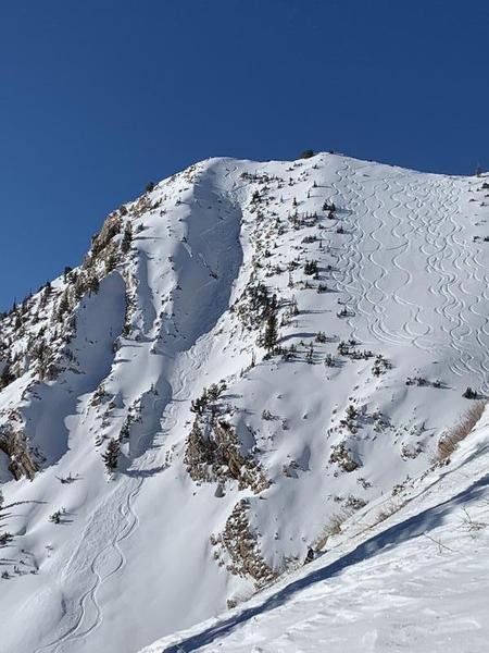
The photo (M. DiBiaso) below of Toledo Chute is a good example of cross loading in which winds blew across the ridgeline formed a slab in the gully. There does not appear to be a slab of wind drifted snow further right in the photo were there are ski tracks and no avalanches.
Avalanche Problem #2
Persistent Weak Layer
Type
Location
Likelihood
Size
Description
Old snow on the ground prior to Thanksgiving formed a persistent weak layer of sugary, faceted snow crystals. Many slab avalanches slid on this layer in late November and early December. This layer has been dormant since then; however, yesterday's avalanche near SLC in Days Draw is a good heads up that this problem still exists and likely remains a problem in the Provo area. We have a lot of uncertainty with respect to this layer but we know it exists.
Rocky, northerly facing terrain at upper elevations with an fresh load of wind drifted snow is the most likely place for an avalanche to break on this layer near the ground. This layer exists on other aspects like W and SE but it is less likely to produce avalanches in these locations.
General Announcements
This information does not apply to developed ski areas or highways where avalanche control is normally done. This forecast is from the U.S.D.A. Forest Service, which is solely responsible for its content. This forecast describes general avalanche conditions and local variations always occur.