UDOT PLANNED AVALANCHE CLOSURES!!

Forecast for the Provo Area Mountains

Mark Staples
Issued by Mark Staples for
Thursday, December 1, 2022
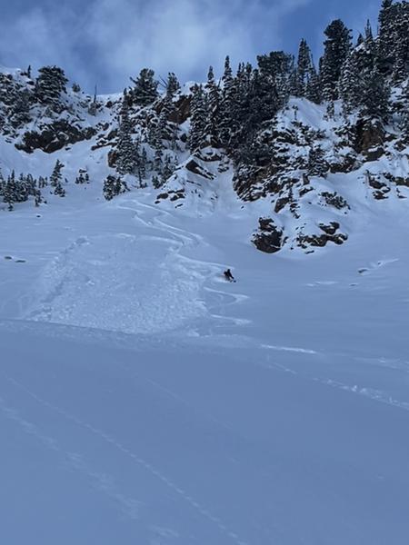
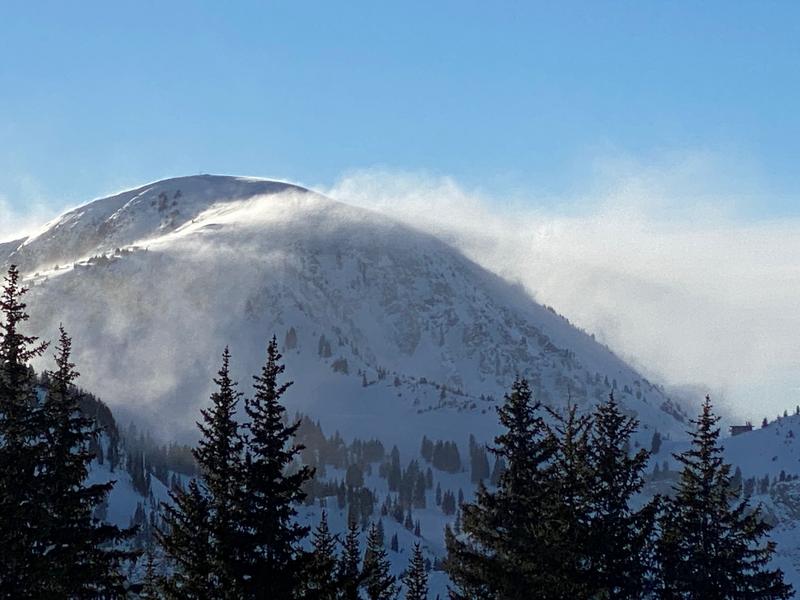
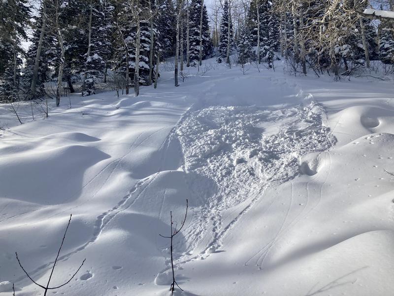
It's all about the wind today. Very strong winds from the south blew all day yesterday transporting snow and forming hard slabs of wind drifted snow. These winds have created dangerous avalanche conditions at upper elevations where the danger is CONSIDERABLE.
Mid elevations have been affected by strong winds as well and have a MODERATE avalanche danger with heightened avalanche conditions on slopes loaded by the south winds.
Low elevations have also gotten raked by winds but just have less snow and the danger is LOW

HEADS UP - It is time to step back. There is a widespread persistent weak layer buried under Tuesday's new snow. Winds have been relentless. There is another major storm coming tonight, and more snow likely on Sunday/Monday.
Low
Moderate
Considerable
High
Extreme
Learn how to read the forecast here
Avalanche Warning
Widespread avalanche activity is expected and the avalanche danger will be HIGH. In effect from 3 p.m. MST this afternoon until 6 a.m. MST Saturday. For the mountains of Northern Utah including the Wasatch Range, Bear River Range, and Western Uinta Range. A rapid load of heavy snow combined with very strong winds and preexisting weaknesses in the snowpack will create very dangerous avalanche conditions. Both human triggered and natural avalanches are likely. Stay off of and out from under slopes steeper than 30 degrees.
Special Announcements
Join the Utah Avalanche Center and the Utah Division of Outdoor Recreation to celebrate the Fourth Annual Avalanche Awareness week, from December 4 - December 11. Click HERE to view the full list of events for the week.
Weather and Snow
WIND - Winds from the south continue to rake across the Wasatch Mountains. This morning they are steadily blowing 25 mph across ridgelines. Upper elevations have wind gusts of 50-70 mph. These winds should be at their strongest midday today.
It's also relatively warm with temperatures at low elevations in the mid 30s F. Temperatures above 9000 ft are in the low 20s F. Today temperatures should warm a few degrees. Clouds will gradually build as the day progresses, and snowfall may start after 5 p.m.
The National Weather Service has issued a Winter Storm Watch from tonight at 9 p.m. until tomorrow at 3 p.m. The heaviest snowfall should happen in the early morning hours tomorrow with snowfall rates greater than 2 inches per hour for several hours. Total precipitation should be 10-18 inches of snow (0.9-1.4 inches of water).
Snow conditions took a dramatic turn for the worse yesterday with a combination of very strong south winds and warm temperatures. Mid elevation sheltered slopes still have some soft powder.
Recent Avalanches
We have received many excellent observations over the last several days. Most of them from a little further north in the Cottonwoods, and they are worth reading. Please keep them coming. You can submit obs HERE or via the link at the top of this page.
Strong south winds blowing extraordinary amounts of snow made it hard to see if there was more avalanche activity, but some were spotted. A few naturally triggered slides occurred:
One small avalanche (15" deep, 35' wide) was triggered by skiers in White Pine in Little Cottonwood (photo below, D. Telleson)
Another very small slide was spotted in that same drainage.
Ad
Avalanche Problem #1
Wind Drifted Snow
Type
Location
Likelihood
Size
Description
Winds were transporting a ton of snow yesterday and will continue doing the same today. They have formed many large, hard slabs of wind drifted snow that can be triggered. With winds increasing midday, I wouldn't be surprised if a few of these wind slabs release naturally.
Photo of south winds transporting snow in Little Cottonwood Canyon (E. Shmookler).
Avalanche Problem #2
Persistent Weak Layer
Type
Location
Likelihood
Size
Description
Dry and cold weather during the middle two weeks of November created a persistent weak layer (PWL) of facets on nearly all slopes. This PWL is now covered by a soft slab of snow about 10-18 inches thick from Tuesday's storm. It has produced many small avalanches (photo below) giving us a clear warning.
Today - More small avalanches are possible. The best place to trigger one will be on slopes with some wind drifted snow.
Tomorrow - Heavy snowfall tonight and tomorrow will make avalanches on this layer larger and they will become very likely. They will either happen on their own as slopes are overloaded by snowfall or will be easily triggered.
Photo of small avalanche in the White Pine drainage of Little Cottonwood (S. Zimmerman-Wall)
General Announcements

This information does not apply to developed ski areas or highways where avalanche control is normally done. This forecast is from the U.S.D.A. Forest Service, which is solely responsible for its content. This forecast describes general avalanche conditions and local variations always occur.